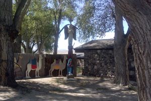
Trips Places Foods Stories Newsletters

Take your next trip with Atlas Obscura!

Our small-group adventures are inspired by our Atlas of the world's most fascinating places, the stories behind them, and the people who bring them to life.

Visit Adventures
Trips Highlight
Central Asia yurt night stars
Uzbekistan • 15 days, 14 nights
Central Asia Road Trip: Backroads & Bazaars
from
A view of Brașov’s Old Town.
Romania • 12 days, 11 nights
Legends of Romania: Castles, Ruins & Culinary Delights
from
View all trips
Top Destinations
Latest Places
Most Popular Places Random Place Lists Itineraries
Add a Place
Download the App
Top Destinations
View All Destinations »

Countries

  • Australia
  • Canada
  • China
  • France
  • Germany
  • India
  • Italy
  • Japan

Cities

  • Amsterdam
  • Barcelona
  • Beijing
  • Berlin
  • Boston
  • Budapest
  • Chicago
  • London
  • Los Angeles
  • Mexico City
  • Montreal
  • Moscow
  • New Orleans
  • New York City
  • Paris
  • Philadelphia
  • Rome
  • San Francisco
  • Seattle
  • Stockholm
  • Tokyo
  • Toronto
  • Vienna
  • Washington, D.C.
Latest Places
View All Places »
The Eye of God at Newchurch in Pendle
St. Govor’s Well.
St. Govor’s Well
Shivsrushti
Pierced domes of Hammam Seffarine.
Hammam Seffarine
Latest Places to Eat & Drink
View All Places to Eat »
Cacio e pepe lasagna combines two classics.
C'è pasta... E pasta!
Spaghetto taratatà is named for the sound of rattling sabers.
Giano Restaurant
The gnocchi here get blanketed in a sugo with braised oxtail.
Cesare al Pellegrino
Romans insist you should feel the cracked peppercorns and cheese grains on your tongue.
Flavio al Velavevodetto
Tripe is fried to a crisp.
L’Osteria della Trippa
Recent Stories
All Stories Video Podcast
Most Recent Stories
View All Stories »
Grasshopper Chapel and grounds.
How the Rocky Mountain Locust Plague Spawned Federal Disaster Relief
3 days ago
The Guy Bradley Visitor Center at Flamingo in Everglades National Park.
America’s First Game Warden Died Fighting for the Birds
3 days ago
Echo Park Time Travel Mart.
Atlas Obscura Presents: Traveling Back in Time for Coconut Cake With The Sporkful
4 days ago
One of the PATH’s many entrances.
A Supposedly Boring Mall I Might Actually Visit Again
5 days ago

No search results found for
“”

Make sure words are spelled correctly.

Try searching for a travel destination.

Places near me Random place

Popular Destinations

  • Paris
  • London
  • New York
  • Berlin
  • Rome
  • Los Angeles
Trips Places Foods Stories Newsletters
Sign In Join
Places near me Random place
All the United States Idaho Idaho Initial Point

Idaho Initial Point

A volcanic core jutting above the plain between the Snake and Boise Rivers, a marker identifies the reference point for all U.S. Government Surveys in Idaho.

Kuna, Idaho

Added By
Denver Applehans
Email
Been Here
Want to go
Added to list
Disk marking the Idaho Initial Point   DenverApplehans / Atlas Obscura User
Initial Point platform from the flood plain   DenverApplehans / Atlas Obscura User
Initial Point Platform   DenverApplehans / Atlas Obscura User
Initial Point Plaque   DenverApplehans / Atlas Obscura User
Road to the point and volcanic core.   DenverApplehans / Atlas Obscura User
View from the point   DenverApplehans / Atlas Obscura User
Been Here
Want to go
Added to list

About

As new territory was added to the growing United States of America in the mid-1800s, public lands were officially recorded through a process of survey that mapped sections of land into one-mile square parcels, each containing 640 acres.

When Congress created the Idaho Territory in 1863, in the midst of the U.S. Civil War, it originally included parts of what are today the states of Montana, Wyoming, and Idaho. Because President Lincoln and Congress were concerned with other pressing matters, some of the administrative support to the new Idaho Territory was lacking. Mr. William Wallace, a non-voting delegate from the Idaho Territory, succeeded in amending the Sundry Civil Appropriation Bill to provide $10,000 “for surveys in Idaho.” 

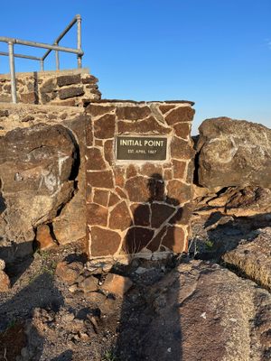
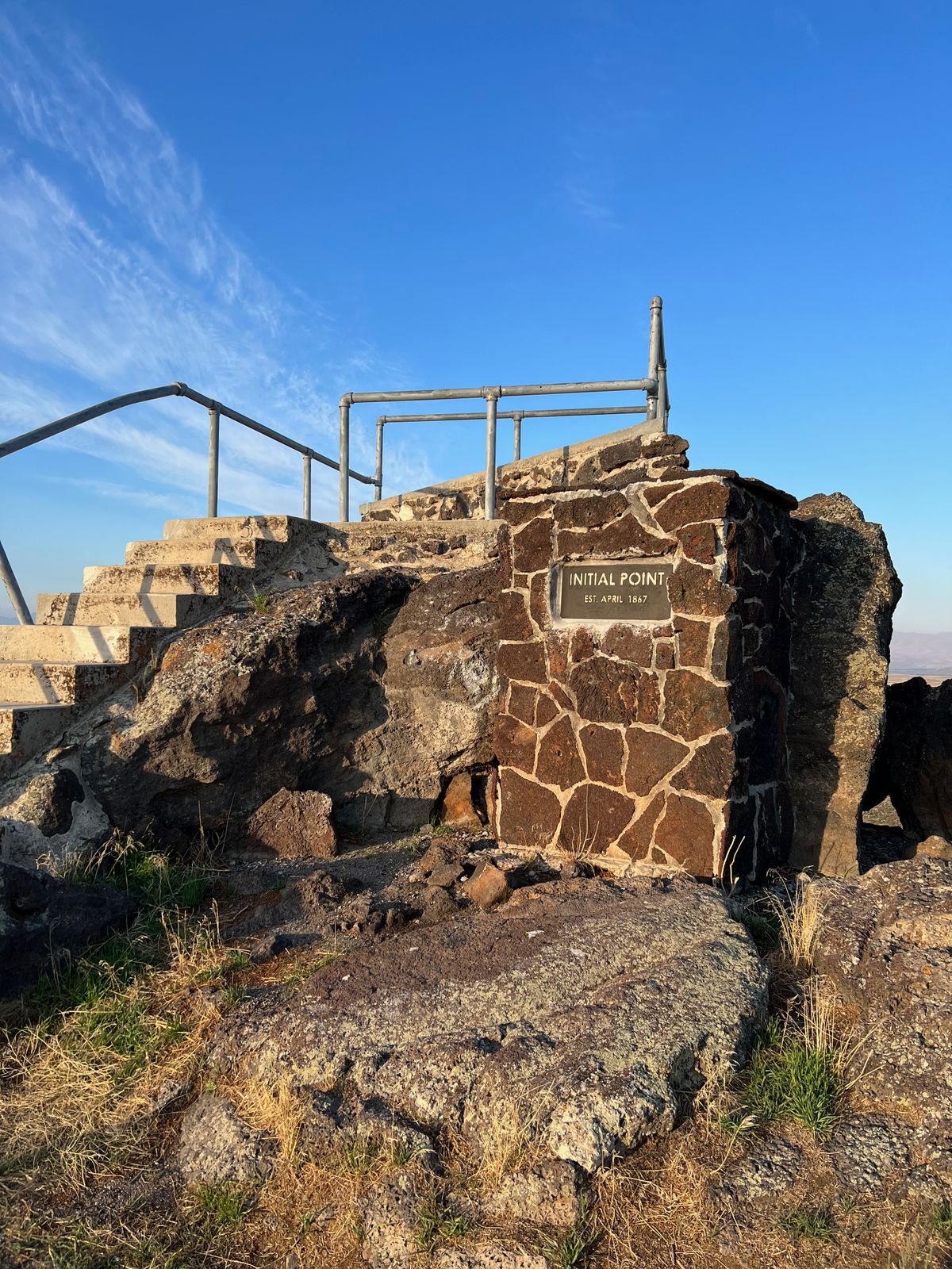
The office of U.S. Surveyor General for Idaho was established in November 1866 and led by Lafayette Cartee. On April 19, 1867, the initial point was established by Peter W. Bell, U.S. Deputy Surveyor, and Cartee’s brother-in-law, under contract No. 1 of the Idaho Office of the U.S. Surveyor General.

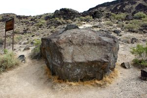
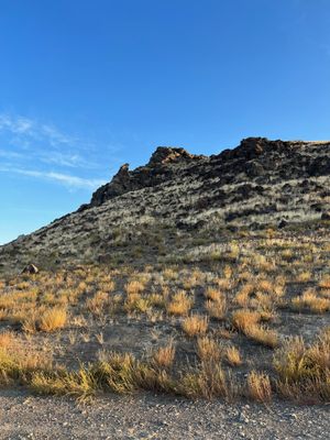
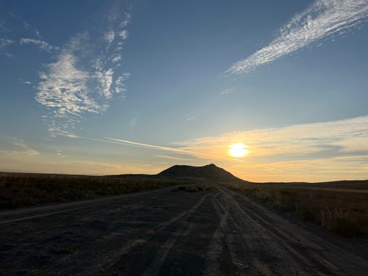
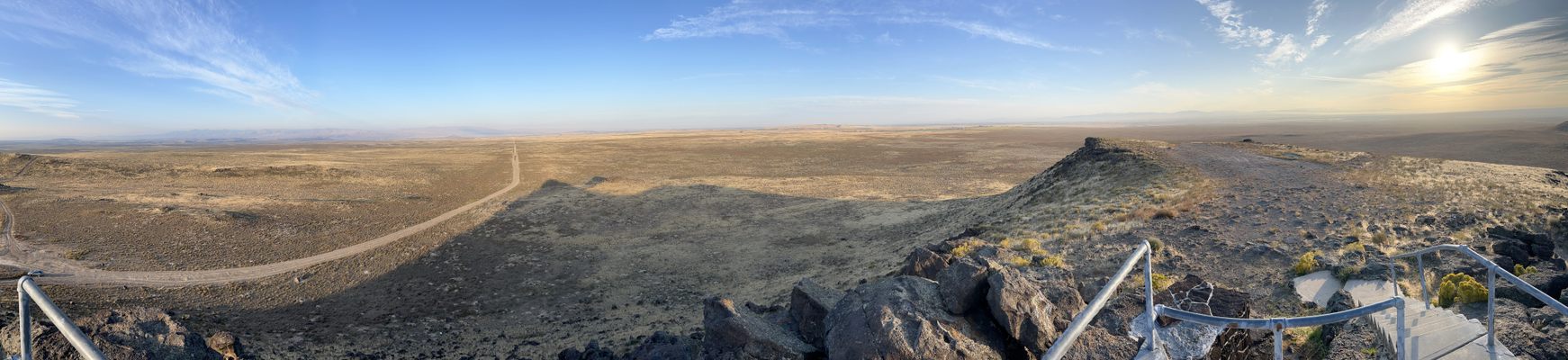
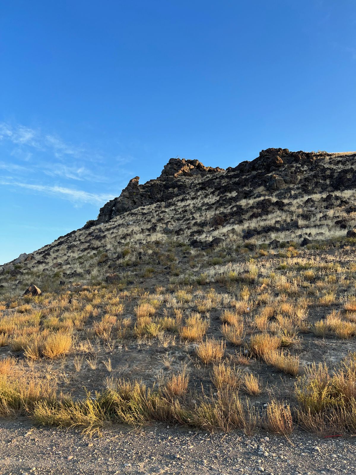
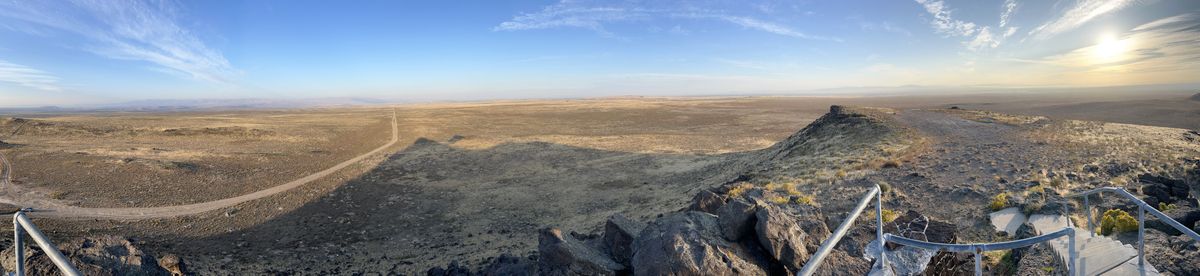
The point was chosen on a volcanic core that stood out above the plain between the Snake and Boise Rivers. Bell used astronomical observations to identify the point and establish the initial point from which all U.S. Government surveys were based in the nearly 54 million acres of land in Idaho. 

The first marker was composed of a “pine post in top of a mound of stone, 6 ft. base and 6 ft. high, with a stone 14x12x4 inches marked with a X laid on north side of post.”

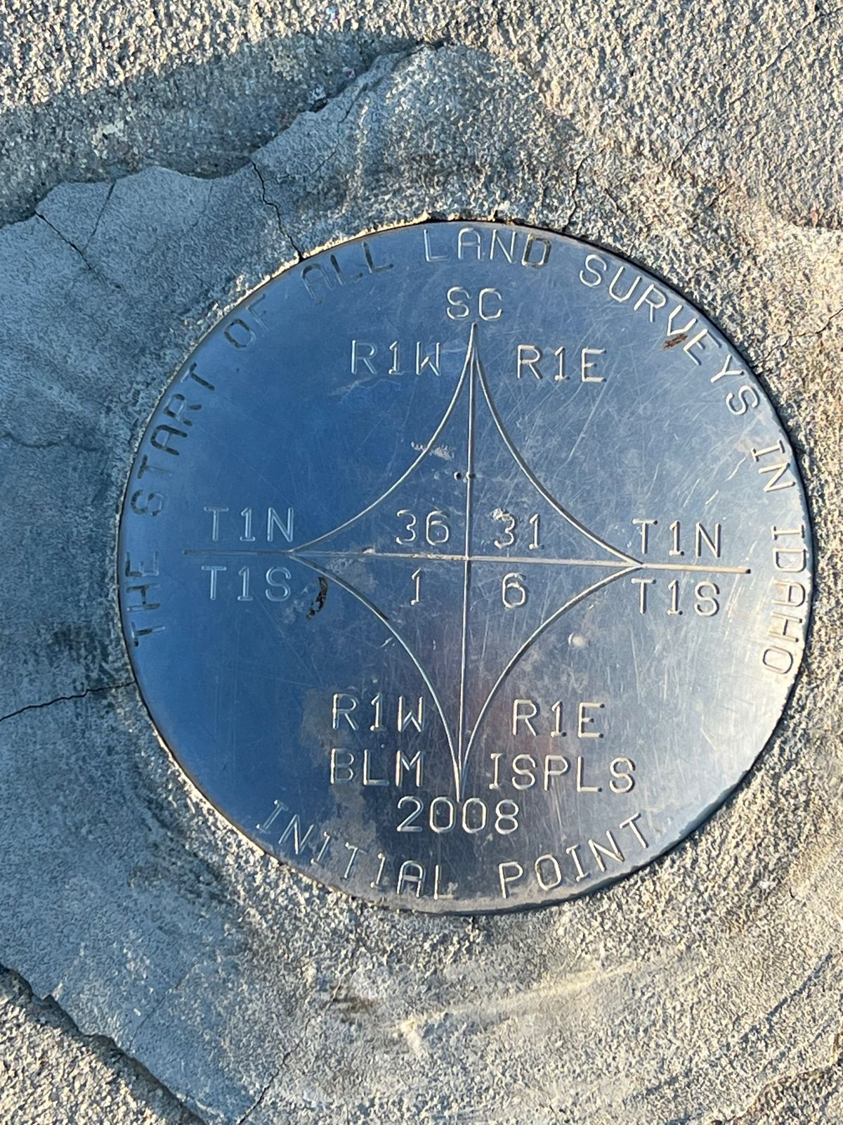
The north-south line from this point is called the Boise Meridian, which runs the entire length of the state north to Canada and south to Nevada. The Idaho city of Meridian was named for the Boise Meridian and lies directly north of the Initial Point. The point is one of 37 federal survey points of origin covering the United States selected over a span of 150 years to map newly acquired federal land. 

Today, the point is marked with a brass disk embedded in concrete on a small platform atop the volcanic core.

Related Tags

Surveyors Cartography Geographic Markers

Know Before You Go

The last mile or so of road to get to the point is gravel and not in great shape. Take care driving on the road, and unless you have 4-wheel drive, it is not recommended that you attempt to drive up the rough road to the summit of the core. Though the path is walkable, it is by no means an easy climb over uneven ground.

Community Contributors

Added By

DenverApplehans

Published

October 19, 2023

Edit this listing

Make an Edit
Add Photos
Sources
  • https://clui.org/ludb/site/boise-meridian-initial-point
  • https://www.ktvb.com/article/news/local/208/local-point-of-generation-for-the-gem-state-anniversary-of-idahos-initial-point/277-80f7410c-5880-433b-b3ed-5af109586c1a
  • McConnell, W. J. (1913). Early History of Idaho. United States: Caxton Printers. Retrieved from https://www.google.com/books/edition/Early_History_of_Idaho/JBMUAAAAYAAJ?hl=en&gbpv=1
  • https://www.idahostatesman.com/news/northwest/idaho/history/article242613491.html
  • https://digitalatlas.cose.isu.edu/geog/demgrphc/surveys.htm
  • http://www.pmproject.org/index.htm
  • https://clui.org/ludb/site/boise-meridian-initial-point
Idaho Initial Point
Kuna, Idaho, 83634
United States
43.372109, -116.394006

Nearby Places

Cleo's Ferry Museum and Nature Trail

Melba, Idaho

miles away

Map Rock

Nampa, Idaho

miles away

Albertsons Stadium

Boise, Idaho

miles away

Explore the Destination Guide

Photo of Idaho

Idaho

United States

Places 67
Stories 12

Nearby Places

Cleo's Ferry Museum and Nature Trail

Melba, Idaho

miles away

Map Rock

Nampa, Idaho

miles away

Albertsons Stadium

Boise, Idaho

miles away

Explore the Destination Guide

Photo of Idaho

Idaho

United States

Places 67
Stories 12

Related Places

  • Markleysburg, Pennsylvania

    Old Tri-State Monument

    This original Mason-Dixon line cairn placed in the 1760s was put in the wrong location because of the gravitational pull of the Allegheny Mountains.

  • Roadside “shrine”, to help identify the location

    Belle Fourche, South Dakota

    Geographical Center of the Entire United States

    Despite monuments in other locations, this spot in a South Dakota field is recognized by the U.S. National Geodetic Survey as the center of the 50 states.

  • Cameron Corner, Australia

    Cameron Corner

    The point where New South Wales meets Queensland and South Australia.

  • North face of the monument.  170 miles, 47 chains from Oregon to here.  A “chain” is 66 feet, so there are 80 chains in a mile.

    Verdi, Nevada

    Von Schmidt Monument

    An iron monument on the 120th meridian as surveyed, one of only four marking the boundary between Nevada and California north of Lake Tahoe.

  • Repère Pierre du Niton

    Geneva, Switzerland

    Repère Pierre du Niton

    This stone in Lake Geneva was once the reference point used to determine altitude in Switzerland.

  • Pune, India

    Zero Stone of Pune

    One in a series of historical markers from the massive 19th-century undertaking to map all of India.

  • Bruère-Allichamps Borne

    Bruère-Allichamps, France

    Bruère-Allichamps Borne Milliaire

    Designed to mark the geographical center of France.

  • You can’t miss the sign, flag, and pyramid.

    Torpshammar, Sweden

    Sweden's Geographical Midpoint

    The "geometrical" center of the country, as calculated in 1947.

Aerial image of Vietnam, displaying the picturesque rice terraces, characterized by their layered, verdant fields.
Atlas Obscura Membership

Become an Atlas Obscura Member


Join our community of curious explorers.

Become a Member

Get Our Email Newsletter

Follow Us

Facebook YouTube TikTok Instagram Pinterest RSS Feed

Get the app

Download the App
Download on the Apple App Store Get it on Google Play
  • All Places
  • Latest Places
  • Most Popular
  • Places to Eat
  • Random
  • Nearby
  • Add a Place
  • Stories
  • Food & Drink
  • Itineraries
  • Lists
  • Video
  • Podcast
  • Newsletters
  • All Trips
  • Family Trip
  • Food & Drink
  • History & Culture
  • Wildlife & Nature
  • FAQ
  • Membership
  • Feedback & Ideas
  • Community Guidelines
  • Product Blog
  • Unique Gifts
  • Work With Us
  • About
  • FAQ
  • Advertise With Us
  • Advertising Guidelines
  • Privacy Policy
  • Cookie Policy
  • Terms of Use
Atlas Obscura

© 2025 Atlas Obscura. All Rights Reserved.