Trips Places Foods Stories Newsletters
Loading...
Loading...
Loading...
Loading...

No search results found for
“”

Make sure words are spelled correctly.

Try searching for a travel destination.

Places near me Random place

Popular Destinations

  • Paris
  • London
  • New York
  • Berlin
  • Rome
  • Los Angeles
Trips Places Foods Stories Newsletters
Sign In Join
Places near me Random place
All the United States South Dakota Belle Fourche Geographical Center of the Entire United States

Geographical Center of the Entire United States

Despite monuments in other locations, this spot in a South Dakota field is recognized by the U.S. National Geodetic Survey as the center of the 50 states.

Belle Fourche, South Dakota

Added By
scfw0x0f
Email
Been Here
Want to go
Added to list
CAPTION
Roadside “shrine”, to help identify the location   scfw0x0f / Atlas Obscura User
Marker   scfw0x0f / Atlas Obscura User
View from the road to the center marker   scfw0x0f / Atlas Obscura User
Been Here
Want to go
Added to list

About

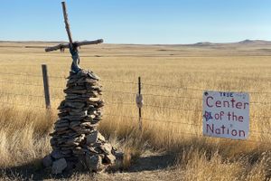
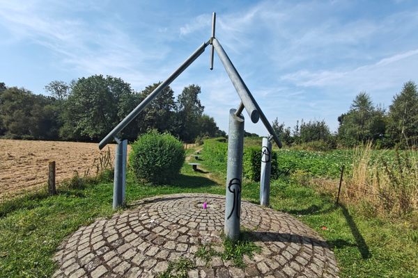
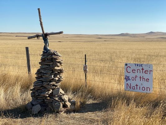
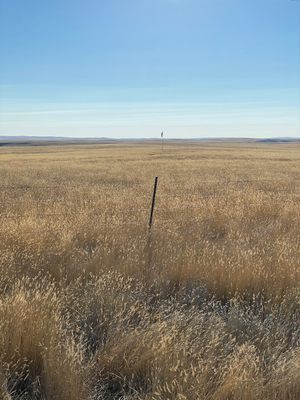
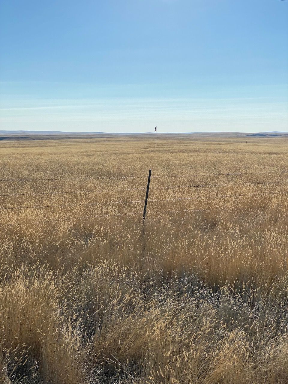
In an open field about 20 miles north of the more accessible Center of the Nation Monument, there is a small marker that indicates the actual center of the United States, as designated by the U.S. National Geodetic Survey.

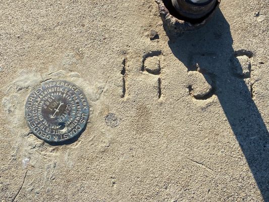
Determining the center of an irregularly shaped land mass sitting on the curved surface of our planet is a difficult task. Coming up with an answer has posed a unique challenge for mathematicians and surveyors. It gets even more complicated when you add factor in pieces of territory that aren't connected to the main land mass. Before Alaska and Hawai'i officially became states in 1959, the center of the country was located in Lebanon, Kansas, where another monument is located just slightly off the official mark. The addition of two new states, each located many miles from the contiguous U.S., shifted the geographic center by some 200 miles.

A small plaque marks the location determined by the U.S. National Geodetic Survey in 1959. It's in a private field with a gate that's usually unlocked; the owner seems to be happy to allow visitors. The location is a few miles off the nearest paved road, but is not a challenging drive.

Related Tags

Surveyors Plaques Geography Geographic Markers

Know Before You Go

This is on private land, but the owner seems to allow visitors.

Community Contributors

Added By

scfw0x0f

Published

February 23, 2024

Edit this listing

Make an Edit
Add Photos
Sources
  • https://www.smithsonianmag.com/smart-news/many-centers-united-states-180955253/
  • https://www.geographyrealm.com/what-is-the-geographic-center-of-the-united-states/
Geographical Center of the Entire United States
Old US Hwy 85
Belle Fourche, South Dakota, 57717
United States
44.967194, -103.771566
Get Directions

Nearby Places

Center of the Nation Monument

Belle Fourche, South Dakota

miles away

Aladdin Coal Tipple

Aladdin, Wyoming

miles away

Fish Car No. 3

Spearfish, South Dakota

miles away

Explore the Destination Guide

Photo of Belle Fourche

Belle Fourche

South Dakota

Places 2

Nearby Places

Center of the Nation Monument

Belle Fourche, South Dakota

miles away

Aladdin Coal Tipple

Aladdin, Wyoming

miles away

Fish Car No. 3

Spearfish, South Dakota

miles away

Explore the Destination Guide

Photo of Belle Fourche

Belle Fourche

South Dakota

Places 2

Related Places

  • Tri-States Monument and Delaware River

    Port Jervis, New York

    Tri-States Monument

    A pair of 19th-century granite markers symbolically record where the state boundaries of New York, New Jersey, and Pennsylvania intersect.

  • 49th Parallel North Monument in Prešov, Slovakia

    Prešov, Slovakia

    49th Parallel North Monument

    A quirky monument to the 49th parallel in downtown Prešov, Slovakia.

  • Aerial view of Walgun / Cape Byron

    Byron Bay, Australia

    Walgun / Cape Byron

    The most easterly point on mainland Australia offers dramatic ocean views.

  • Monument to the geographic center of Belgium

    Walhain, Belgium

    Geographic Center of Belgium

    This metal monument marking the middle of Belgium represents three regions coming together to form one country.

  • Leuven, Belgium

    Middelpunt van Leuven

    This unassuming stone bollard is a centuries-old marker denoting the center of the city.

  • Buggenhout, Belgium

    Middelpunt van Vlaanderen

    The geographic midpoint of the Dutch-speaking part of Belgium.

  • Pointe de Almadies sign

    Dakar, Senegal

    Pointe de Almadies

    This beach in Senegal marks the westernmost point on the African continent.

  • Kinnarodden, the northernmost point of mainland Europe.

    Norway

    Kinnarodden (Cape Nordkinn)

    Remote and wild, Kinnarodden is the northernmost point of mainland Europe.

Aerial image of Vietnam, displaying the picturesque rice terraces, characterized by their layered, verdant fields.
Atlas Obscura Membership

Become an Atlas Obscura Member


Join our community of curious explorers.

Become a Member

Get Our Email Newsletter

Follow Us

Facebook YouTube TikTok Instagram Pinterest RSS Feed

Get the app

Download the App
Download on the Apple App Store Get it on Google Play
  • All Places
  • Latest Places
  • Most Popular
  • Places to Eat
  • Random
  • Nearby
  • Add a Place
  • Stories
  • Food & Drink
  • Itineraries
  • Lists
  • Video
  • Podcast
  • Newsletters
  • All Trips
  • Family Trip
  • Food & Drink
  • History & Culture
  • Wildlife & Nature
  • FAQ
  • Membership
  • Feedback & Ideas
  • Community Guidelines
  • Product Blog
  • Unique Gifts
  • Work With Us
  • About
  • FAQ
  • Advertise With Us
  • Advertising Guidelines
  • Privacy Policy
  • Cookie Policy
  • Terms of Use
Atlas Obscura

© 2025 Atlas Obscura. All Rights Reserved.