Trips Places Foods Stories Newsletters

Take your next trip with Atlas Obscura!

Our small-group adventures are inspired by our Atlas of the world's most fascinating places, the stories behind them, and the people who bring them to life.

Visit Adventures
Trips Highlight
Puglia Italy - Matera
Italy • 8 days, 7 nights
Southern Italy: Castles, Caves & Coastal Treasures in Puglia
from
Turkmenistan Gates of Hell Darvaza crater
Turkmenistan • 10 days, 9 nights
Turkmenistan & the Gates of Hell
from
View all trips
Top Destinations
Latest Places
Most Popular Places Random Place Lists Itineraries
Add a Place
Download the App
Top Destinations
View All Destinations »

Countries

  • Australia
  • Canada
  • China
  • France
  • Germany
  • India
  • Italy
  • Japan

Cities

  • Amsterdam
  • Barcelona
  • Beijing
  • Berlin
  • Boston
  • Budapest
  • Chicago
  • London
  • Los Angeles
  • Mexico City
  • Montreal
  • Moscow
  • New Orleans
  • New York City
  • Paris
  • Philadelphia
  • Rome
  • San Francisco
  • Seattle
  • Stockholm
  • Tokyo
  • Toronto
  • Vienna
  • Washington, D.C.
Latest Places
View All Places »
Parkside Plum Juice
Sanctuary of Nossa Senhora da Conceição da Muxima
The temple and the tree at the square.
The Historical Center of Pune
Dishes at Aksorn are grounded in deep historical research.
Aksorn
Latest Places to Eat & Drink
View All Places to Eat »
Parkside Plum Juice
Dishes at Aksorn are grounded in deep historical research.
Aksorn
Thailand’s hot, humid climate meant that customers wanted an alternative to hot tea.
ChaTraMue
Order a flight of infused ya dong shots.
Tep Bar
Thai-Chinese makes up Bangkok’s largest diaspora.
Nai Ek Roll Noodle
Recent Stories
All Stories Video Podcast
Most Recent Stories
View All Stories »
You could probably take some of that stuff out.
Dear Atlas: How Do I Pack Light for a Long Trip?
Ripples in the land are remnants of the field walls that once held rows of native sugarcane and sweet potatoes.
Unearthing the Mysteries of Hawai'i's Ancient Agriculture
Petrified Forest National Park.
Beware the Legends Behind These National Park Souvenirs
For Aguilar-Carrasco, nature is a powerful reminder of the interconnectedness of all life.
How Can National Parks Be Made Accessible to All? AO Wants to Know.

No search results found for
“”

Make sure words are spelled correctly.

Try searching for a travel destination.

Places near me Random place

Popular Destinations

  • Paris
  • London
  • New York
  • Berlin
  • Rome
  • Los Angeles
Trips Places Foods Stories Newsletters
Sign In Join
Places near me Random place
All the United States New York State New York City Port Jervis Tri-States Monument
AO Edited

Tri-States Monument

A pair of 19th-century granite markers symbolically record where the state boundaries of New York, New Jersey, and Pennsylvania intersect.

Port Jervis, New York

Added By
Anna Minster
Email
Been Here
Want to go
Added to list
CAPTION
Tri-States Monument and Delaware River   Anna Minster / Atlas Obscura User
Tri-States Monument — 2013 top view   Zeete
New York face of the Boundary Monument   Anna Minster / Atlas Obscura User
Tri-States (rear) and Witness Monuments   Zeete
“Tri-States Rock”   Gus Krauss, publisher
Pedestrian entrance at South and High streets   Anna Minster / Atlas Obscura User
Been Here
Want to go
Added to list

About

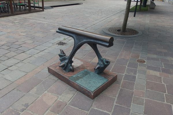
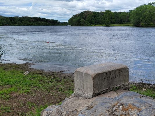
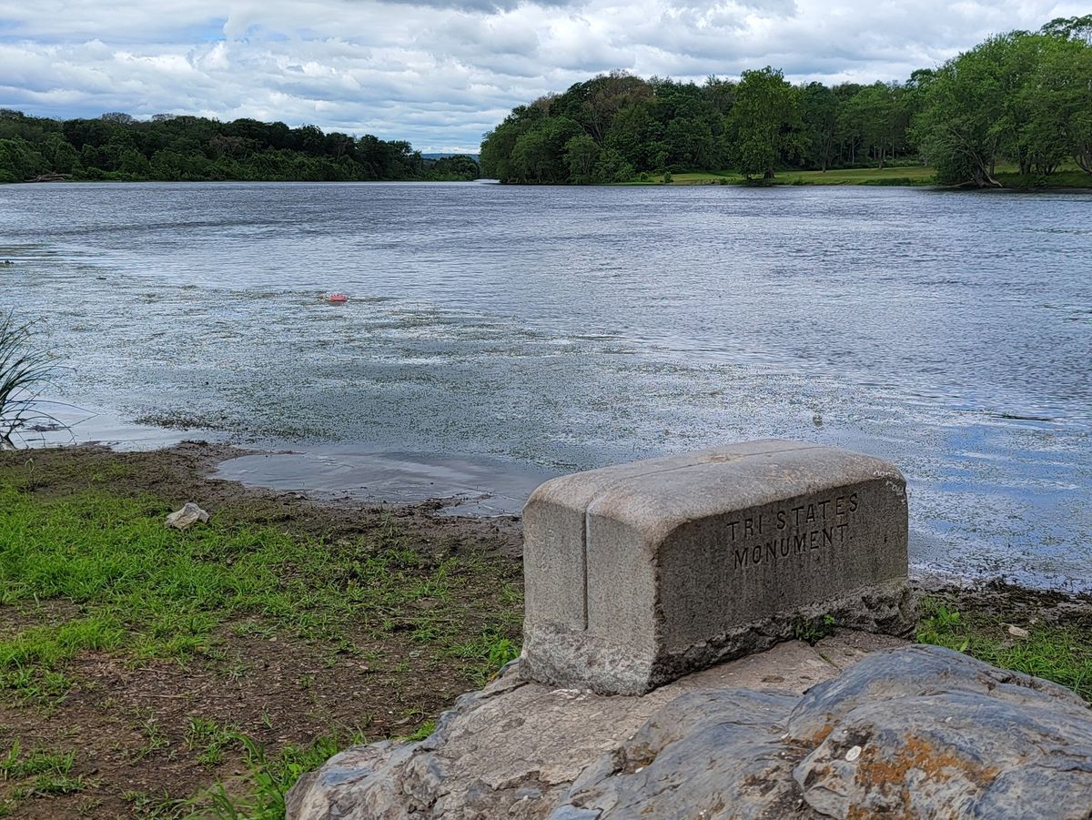
Full disclosure: The Tri-States Monument does not, as is sometimes claimed, actually mark the location where the boundaries of New York, New Jersey, and Pennsylvania meet. The confusion is understandable; the bronze United States Coast and Geodetic survey disc and scored granite marker give the appearance of authority and precision. However, as the nearby Witness Monument makes clear, the state boundaries actually intersect about 475 feet west of the Tri-States Monument, in the middle of the Delaware River. If you are particularly literal, you have been warned.

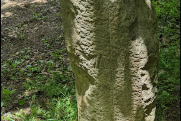
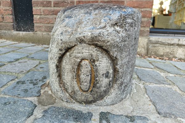
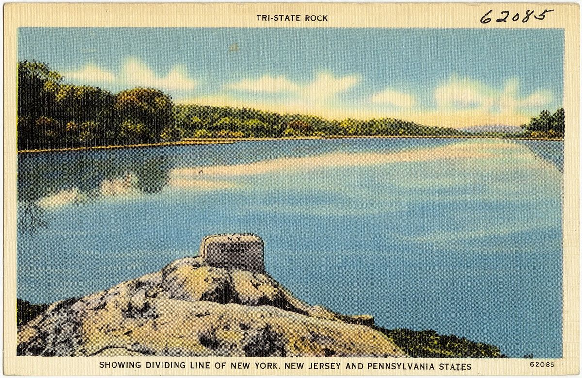
Also known as the Tri-States Rock, the monument was set in place in 1942, replacing earlier, less permanent, or damaged markers. Approximately a half cubic yard in size above bedrock, "Tri-States Monument" is chiseled into the north face. The top is engraved with the initials of the three states and grooves symbolically representing the state boundaries. The federal survey disc, a triangulation station now under the jurisdiction of the National Oceanic and Atmospheric Administration, dates from the same year.

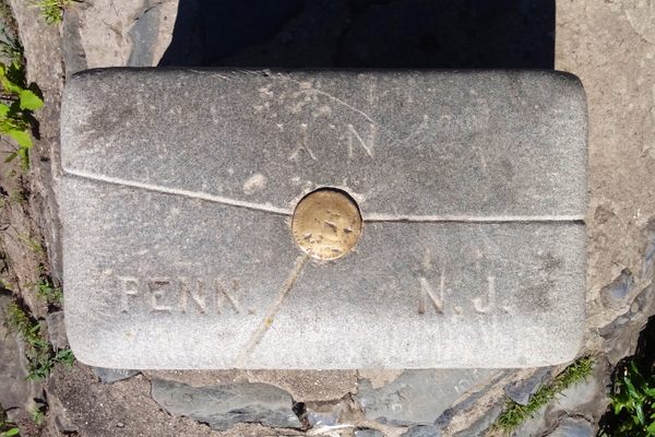
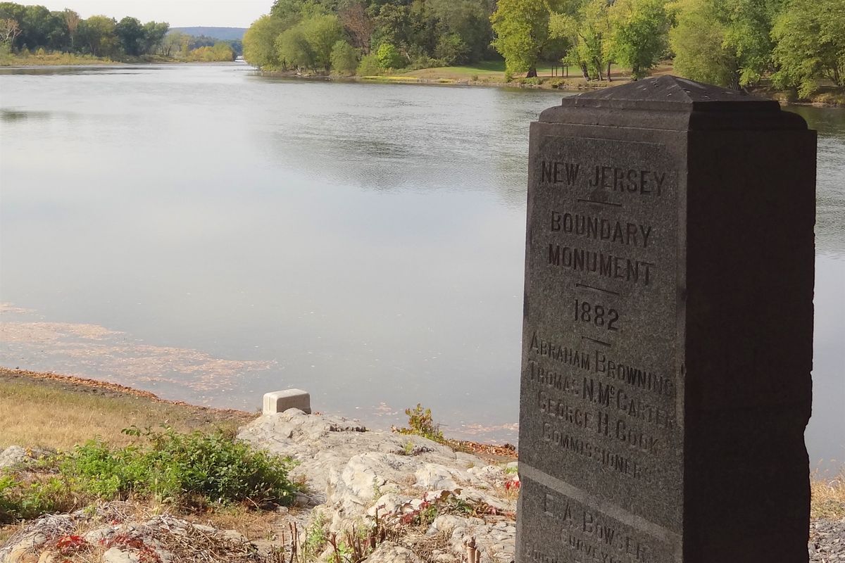
Like the Tri-States Monument, the Witness Monument 25 feet away was originally engraved in 1882 and placed at its current location in 1942. "Boundary Monument" and the earlier date are inscribed on what is also called the Reference Monument, along with verbal descriptions of the marker’s location relative to the Tri-States Monument and the true tripoint of the three states. Also noted for posterity are the names of three New Jersey and three New York commissioners, as well as the surveyors from each state, who certified the two monuments’ locations.

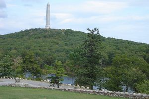
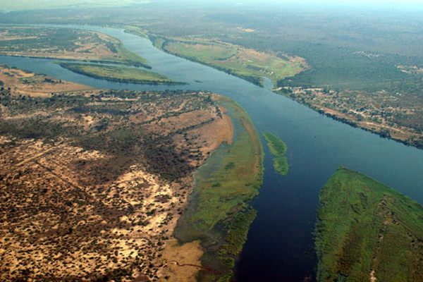
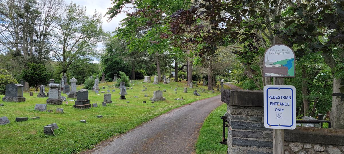
The granite markers are located on what is known as Carpenter’s Point, the tip of a short peninsula between the Delaware and Neversink rivers that is home to the Laurel Grove Cemetery, established in 1856. Aside from its geopolitical significance, Carpenter’s Point is—the traffic overhead on Interstate-84 notwithstanding—a peaceful place to view the Delaware River.

Related Tags

Geographic Oddities Geography Geographic Markers Borders Monuments

Know Before You Go

When using GPS to navigate to the Tri-States Monument, it is advisable to use that place name or the cemetery’s street address (247 East Main Street) as a destination. Geographic coordinates (longitude and latitude) may direct visitors to a location on I-84, above the monument. The entrance to Laurel Grove Cemetery is from US-6 (East Main Street), immediately west of the bridge over the Neversink River. The internal road is one-way, clockwise, and there is parking near the monuments. It is also possible to park where the cemetery road exits at South and High streets and walk a half-mile to the monuments.

The Tri-States Monument is near the eastern shore of the Delaware River. The descent from the parking area and subsequent return are generally manageable but rocky and moderately steep. Reasonable care should be taken, especially if the water is high, for example after the spring snow melt or following heavy rain. The Delaware River can appear deceptively placid but at Port Jervis, averages 7,900 cubic feet of water per second, all flowing towards the Atlantic Ocean.

Community Contributors

Added By

Anna Minster

Published

November 21, 2024

Edit this listing

Make an Edit
Add Photos
Tri-States Monument
247 E Main St
Port Jervis, New York, 12771
United States
41.360316, -74.689368
Get Directions

Nearby Places

High Point Monument

Wantage, New Jersey

miles away

The Hawks Nest

Port Jervis, New York

miles away

Grey Towers

Milford, Pennsylvania

miles away

Explore the Destination Guide

Photo of New York State

New York State

United States

Places 807
Stories 45

Nearby Places

High Point Monument

Wantage, New Jersey

miles away

The Hawks Nest

Port Jervis, New York

miles away

Grey Towers

Milford, Pennsylvania

miles away

Explore the Destination Guide

Photo of New York State

New York State

United States

Places 807
Stories 45

Related Places

  • Markleysburg, Pennsylvania

    Old Tri-State Monument

    This original Mason-Dixon line cairn placed in the 1760s was put in the wrong location because of the gravitational pull of the Allegheny Mountains.

  • North face of the monument.  170 miles, 47 chains from Oregon to here.  A “chain” is 66 feet, so there are 80 chains in a mile.

    Verdi, Nevada

    Von Schmidt Monument

    An iron monument on the 120th meridian as surveyed, one of only four marking the boundary between Nevada and California north of Lake Tahoe.

  • Teec Nos Pos, Utah

    Four Corners Monument

    The marker offers a rare chance to be in four U.S. states at once, though there's some controversy over its geographic accuracy.

  • African Quadripoint

    Chobe, Botswana

    African Quadripoint

    There is only one place in the world where the corners of four nations come together.

  • 49th Parallel North Monument in Prešov, Slovakia

    Prešov, Slovakia

    49th Parallel North Monument

    A quirky monument to the 49th parallel in downtown Prešov, Slovakia.

  • Wolford Chapel, with its Canadian flag outside.

    Devon, England

    Wolford Chapel

    Despite its location in the English countryside, this chapel is the property of Ontario, Canada.

  • Monument to the geographic center of Belgium

    Walhain, Belgium

    Geographic Center of Belgium

    This metal monument marking the middle of Belgium represents three regions coming together to form one country.

  • Leuven, Belgium

    Middelpunt van Leuven

    This unassuming stone bollard is a centuries-old marker denoting the center of the city.

Aerial image of Vietnam, displaying the picturesque rice terraces, characterized by their layered, verdant fields.
Atlas Obscura Membership

Become an Atlas Obscura Member


Join our community of curious explorers.

Become a Member

Get Our Email Newsletter

Follow Us

Facebook YouTube TikTok Instagram Pinterest RSS Feed

Get the app

Download the App
Download on the Apple App Store Get it on Google Play
  • All Places
  • Latest Places
  • Most Popular
  • Places to Eat
  • Random
  • Nearby
  • Add a Place
  • Stories
  • Food & Drink
  • Itineraries
  • Lists
  • Video
  • Podcast
  • Newsletters
  • All Trips
  • Family Trip
  • Food & Drink
  • History & Culture
  • Wildlife & Nature
  • FAQ
  • Membership
  • Feedback & Ideas
  • Community Guidelines
  • Product Blog
  • Unique Gifts
  • Work With Us
  • About
  • FAQ
  • Advertise With Us
  • Advertising Guidelines
  • Privacy Policy
  • Cookie Policy
  • Terms of Use
Atlas Obscura

© 2025 Atlas Obscura. All Rights Reserved.