Trips Places Foods Stories Newsletters

Take your next trip with Atlas Obscura!

Our small-group adventures are inspired by our Atlas of the world's most fascinating places, the stories behind them, and the people who bring them to life.

Visit Adventures
Trips Highlight
Taktsang Lhakhang, also known as the “Tiger’s Nest”.
Bhutan • 11 days, 10 nights
Festivals & Temples of Bhutan
from
Macchu Picchu
Peru • 10 days, 9 nights
Peru: Machu Picchu & the Last Incan Bridges
from
View all trips
Top Destinations
Latest Places
Most Popular Places Random Place Lists Itineraries
Add a Place
Download the App
Top Destinations
View All Destinations »

Countries

  • Australia
  • Canada
  • China
  • France
  • Germany
  • India
  • Italy
  • Japan

Cities

  • Amsterdam
  • Barcelona
  • Beijing
  • Berlin
  • Boston
  • Budapest
  • Chicago
  • London
  • Los Angeles
  • Mexico City
  • Montreal
  • Moscow
  • New Orleans
  • New York City
  • Paris
  • Philadelphia
  • Rome
  • San Francisco
  • Seattle
  • Stockholm
  • Tokyo
  • Toronto
  • Vienna
  • Washington, D.C.
Latest Places
View All Places »
The ‘Old Secretariat’ government building in New Delhi.
The 'Old Secretariat'
This set is inspired by a Roman arena.
Bozdağ Film Platolari
The Sea Water Distilling Plant.
Sea Water Distilling Plant
Contemplative paths.
Ayo Rock Formations
Latest Places to Eat & Drink
View All Places to Eat »
The sign declares this the number-one gumbo shop in town.
Gumbo Hut Shioya
The pavlova comes crowned with jewel-like fruit.
Central Park Boathouse
The Village Tavern of Long Grove - exterior.
The Village Tavern
Hunter House Hamburgers
L’Escamoteur
Recent Stories
All Stories Video Podcast
Most Recent Stories
View All Stories »
The truth is out there—somewhere.
The Truth Is Out There at the Dreamland Resort (or Should We Say ‘Area 51?’)
19 days ago
Edward Payson Weston
How the 6-Day Race Became an American Spectator Obsession
20 days ago
Alresford Spy Toilet
This Public Bathroom in a Sleepy English Village Was an Epicenter for Cold War Espionage
22 days ago
Manhattan Well
The Manhattan Well: How Aaron Burr and Alexander Hamilton United to Solve a Murder Mystery
23 days ago

No search results found for
“”

Make sure words are spelled correctly.

Try searching for a travel destination.

Places near me Random place

Popular Destinations

  • Paris
  • London
  • New York
  • Berlin
  • Rome
  • Los Angeles
Trips Places Foods Stories Newsletters
Sign In Join
Places near me Random place
All the United States New York State New York City Brooklyn '3M' Mile Marker on Ocean Parkway
AO Edited

'3M' Mile Marker on Ocean Parkway

The last remaining 19th-century mile marker along the historic Ocean Parkway.

Brooklyn, New York

Added By
YeleFit
Email
Been Here
Want to go
Added to list
  YeleFit / Atlas Obscura User
  YeleFit / Atlas Obscura User
  YeleFit / Atlas Obscura User
  YeleFit / Atlas Obscura User
  YeleFit / Atlas Obscura User
Been Here
Want to go
Added to list

About

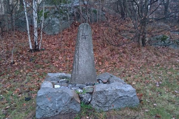
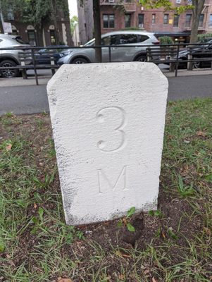
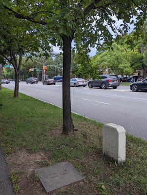
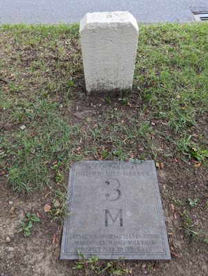
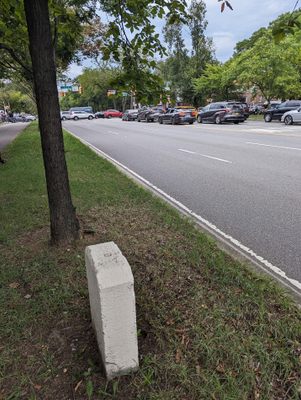
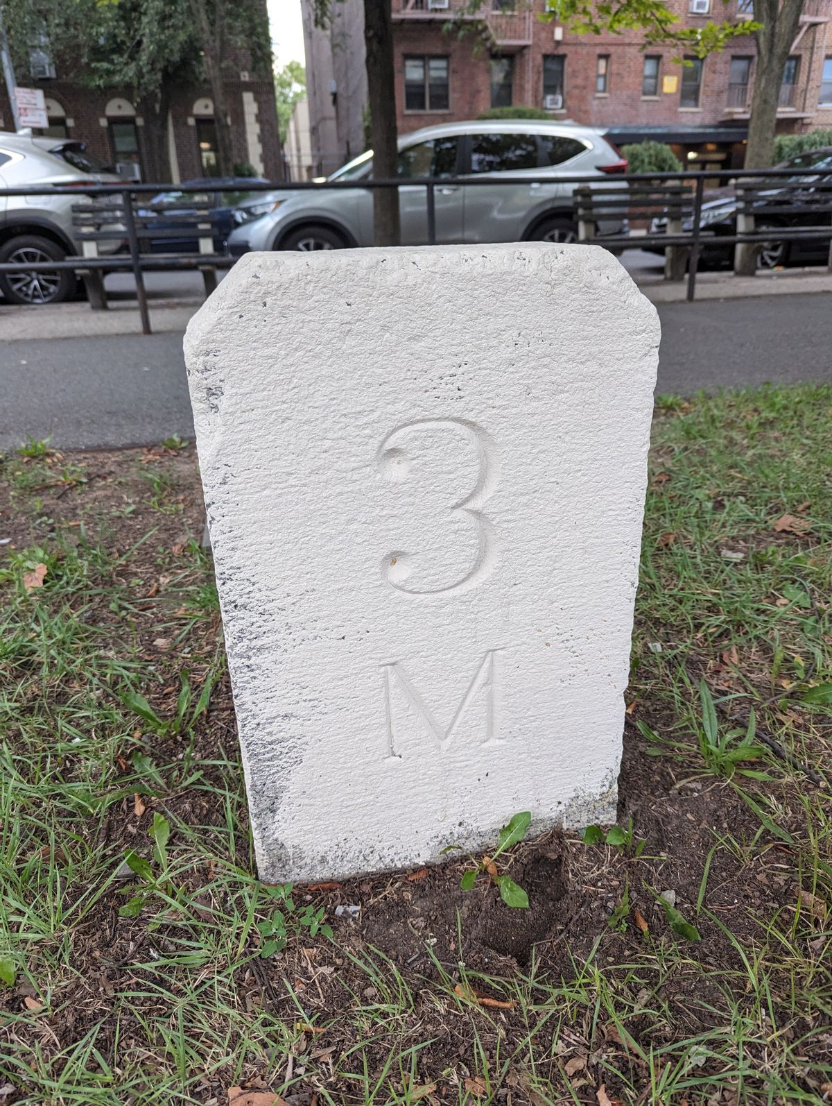
Just south of Avenue P on the west side of Brooklyn's Ocean Parkway, a small, one-foot-tall granite rectangle juts out of the ground with a mysterious "3M" carved into its traffic-facing side.

This inconspicuous stone was once a mile marker on Ocean Parkway, a street inspired by the grand boulevards of Paris and Berlin, built between 1874 and 1880 in the middle of Brooklyn, New York.

Originally, Ocean Parkway was a shortcut for pedestrian and horse traffic, as well as strollers and carriages, to Coney Island Beach from Prospect Park. When the parkway was first built, bicycles still had yet to be invented. This mile marker was one of 11 placed every half mile from Prospect Park Circle to the end of Ocean Parkway in Coney Island.

According to the Brooklyn Park Commission, which managed the parkway, it is likely that they were erected around 1876. But over the decades, by 2000, all but the three-mile marker by Avenue P and the five-mile marker on Neptune Avenue had been removed. The five-mile stone was subsequently removed around 2010 when a bus shelter was installed. Today, only the three-mile marker remains. 

Mile markers were a common way to mark private roads from colonial times until the early 20th century. They told the coaches and riders how many miles they had covered and how much further they had to go. Several roads in the city had similar passing signs: the old Bloomingdale Road (now Broadway) in Upper Manhattan, as well as Jackson Avenue (now Northern Boulevard) in Queens, Kings Highway in Brooklyn, and the Boston Post Road between New York City and Boston, Massachusetts.

Related Tags

Geographic Markers Transportation Travel History & Culture Roads

Community Contributors

Added By

YeleFit

Published

October 11, 2023

Edit this listing

Make an Edit
Add Photos
'3M' Mile Marker on Ocean Parkway
1622 Ocean Pkwy
Brooklyn, New York, 11223
United States
40.608913, -73.968264
Get Directions

Nearby Places

Vitagraph Smokestack

Brooklyn, New York

miles away

Gravesend

Brooklyn, New York

miles away

Avenue H Station House

Brooklyn, New York

miles away

Explore the Destination Guide

Photo of Brooklyn

Brooklyn

New York

Places 241
Stories 46

Nearby Places

Vitagraph Smokestack

Brooklyn, New York

miles away

Gravesend

Brooklyn, New York

miles away

Avenue H Station House

Brooklyn, New York

miles away

Explore the Destination Guide

Photo of Brooklyn

Brooklyn

New York

Places 241
Stories 46

Related Places

  • Come journey into the feudal past.

    Hakone, Japan

    Old Tokaido Way

    The centuries-old cobblestones of a feudal highway remain in the woods of Hakone.

  • Qaqortoq, Greenland. The town’s helipad can be seen on the far left.

    Qaqortoq, Greenland

    Qaqortoq Road

    In a country where driving from one town to another is literally impossible, this small stretch of gravel is a remarkable feat.

  • No. 2 Plank Road Tollgate House.

    Okemos, Michigan

    No. 2 Plank Road Tollgate House

    The last remaining tollhouse in Michigan built during the 19th-century plank road craze.

  • The pharmacy

    Wiesloch, Germany

    Stadtapotheke Wiesloch

    This inconspicuous pharmacy went down in history as the first gas station in the world after fueling the first road trip ever taken.

  • Stockholm, Sweden

    1/4 Milestone of Stockholm

    This stone obelisk is a relic of the 17th-century Swedish mile markers.

  • Looking down Lake Como road at sunset

    Blanca, Colorado

    Lake Como Road

    The worst road in Colorado is the main gateway to some of its highest peaks.

  • Looking south not far from Caliente.  The paved path to the right of the highway connects Caliente with Kershaw-Ryan State Park and is open to non-motorized traffic.

    Etna, Nevada

    Meadow Valley Wash

    Much of the spectacular canyon followed over a century ago by the Los Angeles & Salt Lake railroad is now accessible to cars.

  • Swales (wagon ruts) at Lobanillo Swales

    Bronson, Texas

    Lobanillo Swales

    The preserved wheel ruts of El Camino Real de los Tejas, an 18th-century Spanish colonial road across America's Southwest.

Aerial image of Vietnam, displaying the picturesque rice terraces, characterized by their layered, verdant fields.
Atlas Obscura Membership

Become an Atlas Obscura Member


Join our community of curious explorers.

Become a Member

Get Our Email Newsletter

Follow Us

Facebook YouTube TikTok Instagram Pinterest RSS Feed

Get the app

Download the App
Download on the Apple App Store Get it on Google Play
  • All Places
  • Latest Places
  • Most Popular
  • Places to Eat
  • Random
  • Nearby
  • Add a Place
  • Stories
  • Food & Drink
  • Itineraries
  • Lists
  • Video
  • Podcast
  • Newsletters
  • All Trips
  • Family Trip
  • Food & Drink
  • History & Culture
  • Wildlife & Nature
  • FAQ
  • Membership
  • Feedback & Ideas
  • Community Guidelines
  • Product Blog
  • Unique Gifts
  • Work With Us
  • About
  • FAQ
  • Advertise With Us
  • Advertising Guidelines
  • Privacy Policy
  • Cookie Policy
  • Terms of Use
Atlas Obscura

© 2025 Atlas Obscura. All Rights Reserved.