Trips Places Foods Stories Newsletters

Take your next trip with Atlas Obscura!

Our small-group adventures are inspired by our Atlas of the world's most fascinating places, the stories behind them, and the people who bring them to life.

Visit Adventures
Trips Highlight
Puglia Italy - Matera
Italy • 8 days, 7 nights
Southern Italy: Castles, Caves & Coastal Treasures in Puglia
from
Turkmenistan Gates of Hell Darvaza crater
Turkmenistan • 10 days, 9 nights
Turkmenistan & the Gates of Hell
from
View all trips
Top Destinations
Latest Places
Most Popular Places Random Place Lists Itineraries
Add a Place
Download the App
Top Destinations
View All Destinations »

Countries

  • Australia
  • Canada
  • China
  • France
  • Germany
  • India
  • Italy
  • Japan

Cities

  • Amsterdam
  • Barcelona
  • Beijing
  • Berlin
  • Boston
  • Budapest
  • Chicago
  • London
  • Los Angeles
  • Mexico City
  • Montreal
  • Moscow
  • New Orleans
  • New York City
  • Paris
  • Philadelphia
  • Rome
  • San Francisco
  • Seattle
  • Stockholm
  • Tokyo
  • Toronto
  • Vienna
  • Washington, D.C.
Latest Places
View All Places »
Pinal Airpark
Note the chrysanthemum crests.
Hachiman Bridge
Clarendon War Memorial.
Clarendon War Memorial
This fried chicken is one of Bangkok’s most famous.
Gai Tord Jae Kee
Latest Places to Eat & Drink
View All Places to Eat »
This fried chicken is one of Bangkok’s most famous.
Gai Tord Jae Kee
Chefs Aruss Lerlerstkull and Atcharaporn Kiatthanawat lean into regional traditions.
Charmgang
The khao soi at Gedhawa comes with a rich, coconutty broth.
Gedhawa
At Nai Mong Hoi Thod, the oyster omelet is worth waiting for.
Nai Mong Hoi Thod
In this deceptively simple dish, top-quality ingredients are paramount.
Kor Panich
Recent Stories
All Stories Video Podcast
Most Recent Stories
View All Stories »
Haleakalā National Park’s summit region, shrouded in the pre-dawn fog.
Beware the Legends Behind These National Park Souvenirs
4 days ago
For Aguilar-Carrasco, nature is a powerful reminder of the interconnectedness of all life.
How Can National Parks Be Made Accessible to All? AO Wants to Know.
4 days ago
Podcast: Finding ‘The Great Gatsby’ in Louisville
5 days ago
Here’s which treats you can safely lug home without risking a fine.
Dear Atlas: What International Food Can I Legally Bring Into the U.S.?
6 days ago

No search results found for
“”

Make sure words are spelled correctly.

Try searching for a travel destination.

Places near me Random place

Popular Destinations

  • Paris
  • London
  • New York
  • Berlin
  • Rome
  • Los Angeles
Trips Places Foods Stories Newsletters
Sign In Join
Places near me Random place
All the United States Washington Point Roberts Point Roberts
AO Edited

Point Roberts

An American city stranded at the tip of a Canadian peninsula where strict adherence to the "49th parallel rule" became problematic.

Point Roberts, Washington

Added By
Lew Blank
Email
Been Here
Want to go
Added to list
Point Roberts.   Madereugeneandrew/cc by-sa 2.0
Point Roberts, USA.   jason/cc by-nc 2.0
The 49th Parallel Monument   notoriousFIG / Atlas Obscura User
Stop. Return to Canada.   pete/cc by-sa 2.0
Warning!   Pete/cc by-sa 2.0
Map of Point Roberts.   USGS/public domain
Lighthouse Park  
Lighthouse Marine Park Southwest Corner of Point Roberts   wildwomenwander / Atlas Obscura User
Been Here
Want to go
Added to list

About

The Convention of 1818 between Britain and America following the War of 1812 had a tough job to take on: determining the border between Canada and the United States. In an effort to avoid controversy and confusion caused by drawing the boundary based on watershed, the two countries agreed on a simpler solution: the 49th parallel.

There were, of course, multiple problems that arose with this solution, including the fact that Vancouver Island was split in two by the imaginary line. The debate over whether the line of latitude should split the island in two or if it should be ignored, giving the full island to Canada, was known as The Oregon Boundary Dispute. In 1846 President James Polk proposed making Vancouver Island an island of two countries, therein designating more land to America, but this was immediately rejected by the British. In the end, the British and Americans agreed to give the entire Vancouver Island to Canada, while giving the San Juan Islands to the United States.

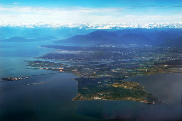
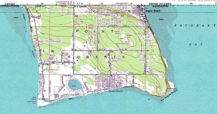
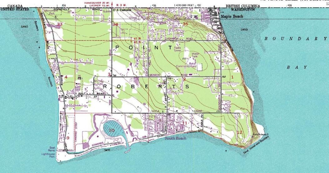
Problem solved, right? Not exactly. Due to limited knowledge of the region's geography at the time, there was one land area that both the Americans and the British failed to notice: The Tsawwassen Peninsula. 

This peninsula was unknown at the time, but once discovered, it was too late. The agreement had accidentally cut off a tiny piece of Canada and given it to the United States.

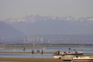
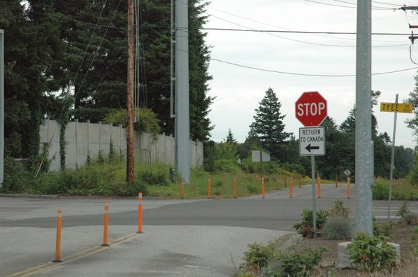
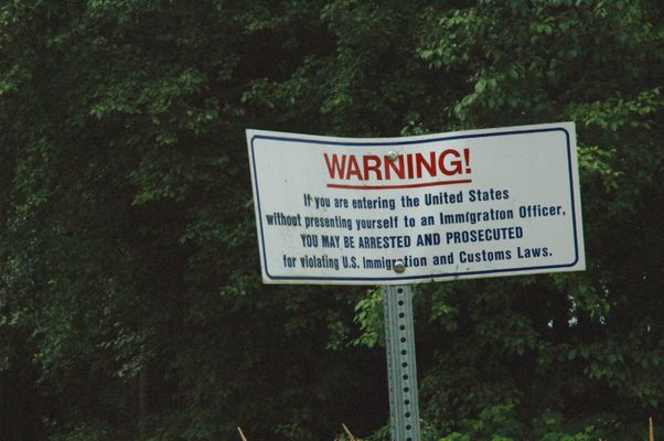
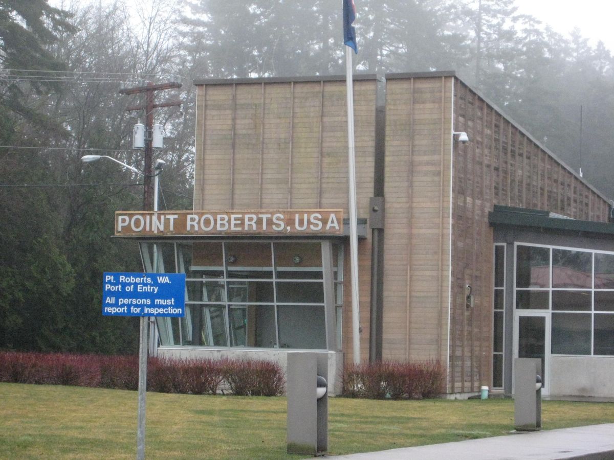
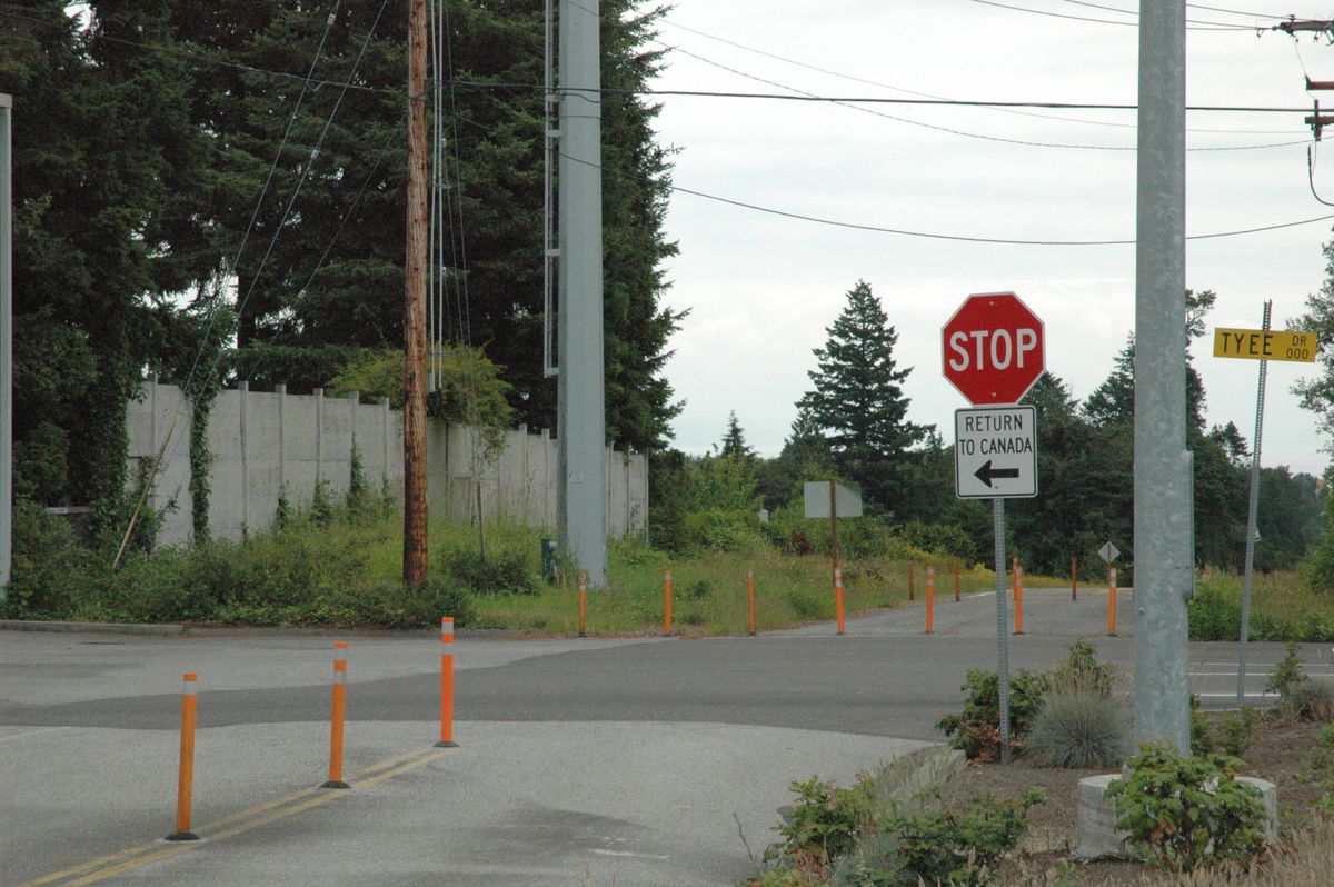
Nowadays, at the end of this peninsula, there is a little American town called Point Roberts, Washington. The only land route out of Point Roberts is through Canada. This town of over 1,000 people has a clinic, a police station, a fire department, a library, a marina, and a primary school.

As a result of this geographic peculiarity, the town has some strange habits. Every day, a large portion of the Canadians living just north travel across the border to buy groceries and gas, which are about a third cheaper in the U.S. It is said that Canadians will also travel over for the medium rare burgers, which are unheard of in Vancouver because of the strict Canadian health code. Point Roberts is also an unusually safe city: because of the border security, the crime rate of Point Roberts is over three times lower than that of Washington as a whole.

Despite all of these intriguing qualities, it seems that keeping this geographically isolated town in working order is remarkably difficult. The county that this town belongs to has been slow in providing it with adequate infrastructure, considering that it took two years to install a single streetlight. Business is slow, except for in the summer, when the residency quintuples due to Canadian tourism. There's no shoe store, no veterinarian, and no dentist. There also isn't a single school that serves students from grades 4-12. To access these things, it's necessary to cross the Canadian border to Tsawwassen, circle to White Rock, Canada, and finally cross the American border to Blaine, Washington. This trip is 40 minutes there, 40 minutes back, and it requires four borders to be crossed. For students who live in Point Roberts, the bus to Blaine High School leaves as early as 6:25 a.m., which is before sunrise on most school days.

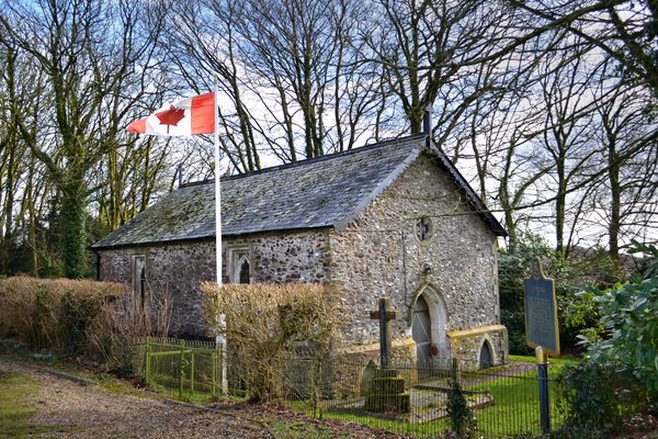
Regardless of the pros and cons, it is quite spectacular that places like these exist. It's a place that's almost as Canadian as it is American, where maple leaf flags fly high (the vast majority of boats in the marina are owned by Canadians). It's a place that is here by accident, by foolishness, a mistake that went unfixed. It also shows the ability of people to adapt, and to make this strange geographical exclave a livable home for over a thousand people.

The Atlas Obscura Podcast is a short, daily celebration of all the world's strange and wondrous places. Check out this episode about Point Roberts.

Related Tags

Borders History Border Crossings Canada Geographic Oddities Territorial Dispute

Community Contributors

Added By

lewblank

Edited By

Blindcolour, MichaelCoxLibrarian, Meg, notoriousFIG...

  • Blindcolour
  • MichaelCoxLibrarian
  • Meg
  • notoriousFIG
  • franknbing
  • wildwomenwander

Published

April 20, 2016

Edit this listing

Make an Edit
Add Photos
Sources
  • https://en.wikipedia.org/wiki/Point_Roberts,_Washington
  • http://news.nationalpost.com/news/canada/point-roberts-washington-a-little-slice-of-the-u-s-only-accessible-through-canada
  • http://www.citylab.com/design/2012/02/strange-existence-point-roberts-washington/1265/
Point Roberts
Point Roberts, Washington, 98281
United States
48.988383, -123.056869

Nearby Places

1001 Steps Park

Surrey, British Columbia

miles away

RAPS Cat Sanctuary

Richmond, British Columbia

miles away

The Great White Rock

White Rock, British Columbia

miles away

Explore the Destination Guide

Photo of Washington

Washington

United States

Places 323
Stories 38

Nearby Places

1001 Steps Park

Surrey, British Columbia

miles away

RAPS Cat Sanctuary

Richmond, British Columbia

miles away

The Great White Rock

White Rock, British Columbia

miles away

Explore the Destination Guide

Photo of Washington

Washington

United States

Places 323
Stories 38

Related Stories and Lists

The 49th Parallel

Podcast

By The Podcast Team

A Border Town Is Now Isolated From Both the U.S. and Canada

maps

By Atlas Obscura

10 Places Caught Up in Odd Border Disputes

geographic markers

By Meg Neal

Related Places

  • Nahwa.

    Nahwa, United Arab Emirates

    Nahwa

    A small United Arab Emirates territory within an Omani enclave within the United Arab Emirates.

  • Dashed line is an international border; Bangladeshi farmer in foreground

    Panchagarh, Bangladesh

    Dahala Khagrabari

    A piece of India inside a piece of Bangladesh inside a piece of India inside a piece of Bangladesh.

  • Wolford Chapel, with its Canadian flag outside.

    Devon, England

    Wolford Chapel

    Despite its location in the English countryside, this chapel is the property of Ontario, Canada.

  • 1915 Michigan border post

    Erie, Michigan

    Michigan's Lost Peninsula

    This small piece of Michigan is entirely surrounded by Ohio.

  • Semināra iela/Sepa tänav border.

    Valga, Estonia

    Valga/Valka Border

    For the last century, this international border within a small town has appeared and disappeared various times.

  • Russian post clearly indicating Border Crossing No. 487.

    Teshig, Mongolia

    Mongolia/Russia Border Crossing No. 487

    This extremely remote border crossing was closed to prevent smuggling and looting.

  • Teec Nos Pos, Utah

    Four Corners Monument

    The marker offers a rare chance to be in four U.S. states at once, though there's some controversy over its geographic accuracy.

  • Mason-Dixon survey stone.

    Delmar, Maryland

    Transpeninsular Midpoint Marker

    The stone marker that Mason and Dixon placed at the eastern end of the famous north-south border they surveyed.

Aerial image of Vietnam, displaying the picturesque rice terraces, characterized by their layered, verdant fields.
Atlas Obscura Membership

Become an Atlas Obscura Member


Join our community of curious explorers.

Become a Member

Get Our Email Newsletter

Follow Us

Facebook YouTube TikTok Instagram Pinterest RSS Feed

Get the app

Download the App
Download on the Apple App Store Get it on Google Play
  • All Places
  • Latest Places
  • Most Popular
  • Places to Eat
  • Random
  • Nearby
  • Add a Place
  • Stories
  • Food & Drink
  • Itineraries
  • Lists
  • Video
  • Podcast
  • Newsletters
  • All Trips
  • Family Trip
  • Food & Drink
  • History & Culture
  • Wildlife & Nature
  • FAQ
  • Membership
  • Feedback & Ideas
  • Community Guidelines
  • Product Blog
  • Unique Gifts
  • Work With Us
  • About
  • FAQ
  • Advertise With Us
  • Advertising Guidelines
  • Privacy Policy
  • Cookie Policy
  • Terms of Use
Atlas Obscura

© 2025 Atlas Obscura. All Rights Reserved.