Trips Places Foods Stories Newsletters
Loading...
Loading...
Loading...
Loading...

No search results found for
“”

Make sure words are spelled correctly.

Try searching for a travel destination.

Places near me Random place

Popular Destinations

  • Paris
  • London
  • New York
  • Berlin
  • Rome
  • Los Angeles
Trips Places Foods Stories Newsletters
Sign In Join
Places near me Random place
All the United States Kansas Liberal Mighty Samson of the Cimarron

Mighty Samson of the Cimarron

Raised high above the Cimarron River, this 1,268-foot rail bridge followed a half-century of trainwrecks, bridge collapses, and an abandoned town.

Liberal, Kansas

Added By
Ian Lefkowitz
Email
Been Here
Want to go
Added to list
CAPTION
The Mighty Samson of the Cimarron   ianlefk / Atlas Obscura User
The Samson of the Cimarron spans more than 1,200 feet in length.   ianlefk / Atlas Obscura User
The historical marker tells the story of Arkalon and the Samson of the Cimarron.   ianlefk / Atlas Obscura User
The Mighty Samson of the Cimarron railroad bridge.   ianlefk / Atlas Obscura User
Been Here
Want to go
Added to list

About

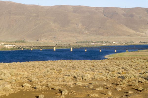
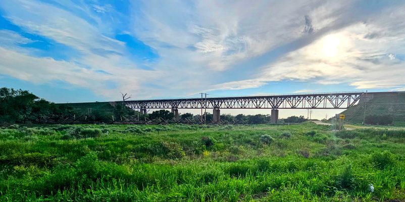
The Samson of the Cimarron is a majestically named railroad bridge that stands tall over the Cimarron River crossing in southwestern Kansas along  U.S. Highway 54. When it was completed in 1939, it solved more than a half-century of headaches, including bridge collapses, train wrecks, and the disappearance of an American city.

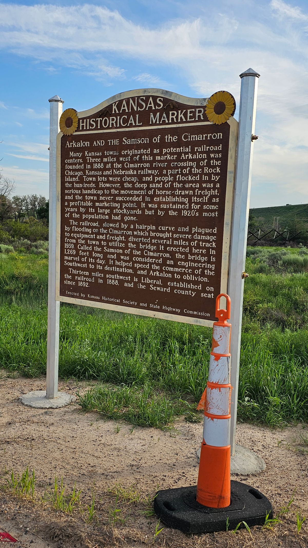
The Rock Island Railroad came to Seward County in 1888, connecting southwest Kansas to the rest of the country. Towns sprang up all around the state, from Liberal in the west to the town of Arkalon, built by the crossing of the Cimarron River. The rise of the railroad was initially looked at as a boon for Arkalon’s future prospects. However, there was a problem. Arkalon, as it turned out, was built on quicksand.

The railroad trestle bridge built in 1888 was soon washed away. Then another, and another. For the next half-century, railroad bridges would malfunction due to frequent river flooding. Even when the bridges were operational, the change in elevation and shape of the river required hairpin turns and miles of curved track, drastically slowing down freight. The deep heavy sand also made life difficult for goods to be shipped on horseback, and made farming unprofitable. By the end of the 1920s, Arkalon was no more.

On August 18, 1938, the problem came to a head. The Gold Ball freight train was navigating the hairpin turn at Arkalon crossing when the bridge gave way, plunging the train into the river. Over the summer, the bridge was quickly repaired, and just as quickly washed out once again. Families began to congregate around the river to gawk, and hamburger stands popped up near the site of the crash. Fed up, Rock Island COO John Farrington made the bold decision to route the railroad high over the river.

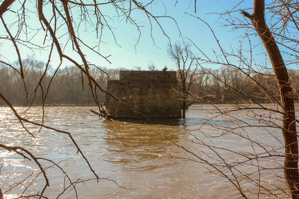
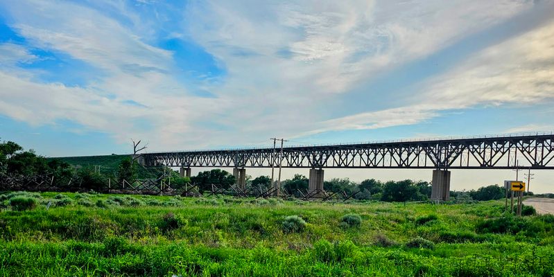
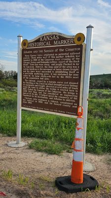
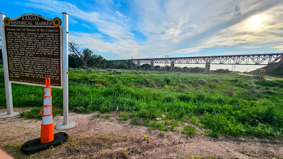
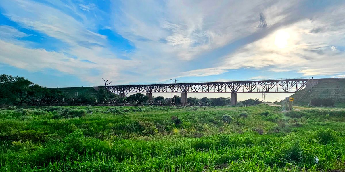
The Mighty Samson of the Cimarron was completed on July 8, 1939, elevating the train tracks 113 feet off the banks of the river. The bridge is 1,268 feet long, and its concrete pilings have been driven 65 feet deep below the riverbed into the soft sand. It was one of the great engineering achievements of its era, and as the nearby historical sign states melodramatically, “It helped speed the commerce of the Southwest to its destination, and Arkalon to oblivion.”

Related Tags

Crash Site Rivers Trains Railroads Bridges

Know Before You Go

The Mighty Samson of the Cimarron is easily visible from U.S. Highway 54, however, a pull-off near Panhandle Road offers a small rest area and historic marker for the best viewing opportunity. Those wishing to explore the former site of Arkalon can visit the nearby Arkalon Park.

Community Contributors

Added By

ianlefk

Published

November 21, 2023

Edit this listing

Make an Edit
Add Photos
Sources
  • https://www.kansasmemory.org/item/228293
  • https://web.archive.org/web/20160506130502/http://www.rits.org/www/structures/cimarron/cimarron106.html
  • https://web.archive.org/web/20160420011156/http://www.leaderandtimes.com/index.php?option=com_content&id=7793:mighty-samson-bridge-nears-73rd-birthday&Itemid=40
  • https://www.hmdb.org/m.asp?m=223938
  • https://kansassampler.org/8wondersofkansas-architecture/mighty-samson-of-the-cimarron-seward-county
Mighty Samson of the Cimarron
227 US-54
Liberal, Kansas, 67901
United States
37.150788, -100.749203
Get Directions

Nearby Places

Dorothy's House and Land of Oz

Liberal, Kansas

miles away

International Pancake Day Hall of Fame

Liberal, Kansas

miles away

Mid-America Air Museum

Liberal, Kansas

miles away

Explore the Destination Guide

Photo of Liberal

Liberal

Kansas

Places 4

Nearby Places

Dorothy's House and Land of Oz

Liberal, Kansas

miles away

International Pancake Day Hall of Fame

Liberal, Kansas

miles away

Mid-America Air Museum

Liberal, Kansas

miles away

Explore the Destination Guide

Photo of Liberal

Liberal

Kansas

Places 4

Related Places

  • Beverly Bridge in 2003, looking southeast.

    Beverly, Washington

    Beverly Bridge

    A large, historic railroad trestle over the Columbia River is now open for non-motorized traffic.

  • Goz Abu Goma Bridge

    Kosti, Sudan

    Goz Abu Goma Bridge

    One of the largest early 20th-century bridges in Sudan.

  • Gokteik Viaduct

    Nawnghkio, Myanmar (Burma)

    Gokteik Viaduct

    The highest bridge in Myanmar was once the tallest railway bridge in the world.

  • section of the bridge

    Orbost, Australia

    Snowy River Railway Bridge

    When it was built in 1916, this bridge was critical infrastructure for local farmers. Today, it's being restored for walking and biking.

  • Train rounding a bend.  Looking back.

    Clarkdale, Arizona

    Verde Canyon Railroad

    An excursion train traverses a picturesque red-rock canyon along the Verde River.

  • Manteno, Illinois

    Decatur & State Line Railway Bridge Piers

    Meant for a railway that was never built because of the Great Chicago Fire, these piers still stand nearly 150 years after they were installed.

  • Transrapid series 09 vehicle at the Emsland Test Facility

    Lathen, Germany

    Emsland Maglev-Test Facility

    A decomissioned facility where the German "Transrapid" maglev trains were once tested.

  • Marker of the Eastern Subcontinental Divide.

    Atlanta, Georgia

    Eastern Sub-Continental Divide Mural

    A little-known mural reveals the hydrological reason for Atlanta's founding in this location.

Aerial image of Vietnam, displaying the picturesque rice terraces, characterized by their layered, verdant fields.
Atlas Obscura Membership

Become an Atlas Obscura Member


Join our community of curious explorers.

Become a Member

Get Our Email Newsletter

Follow Us

Facebook YouTube TikTok Instagram Pinterest RSS Feed

Get the app

Download the App
Download on the Apple App Store Get it on Google Play
  • All Places
  • Latest Places
  • Most Popular
  • Places to Eat
  • Random
  • Nearby
  • Add a Place
  • Stories
  • Food & Drink
  • Itineraries
  • Lists
  • Video
  • Podcast
  • Newsletters
  • All Trips
  • Family Trip
  • Food & Drink
  • History & Culture
  • Wildlife & Nature
  • FAQ
  • Membership
  • Feedback & Ideas
  • Community Guidelines
  • Product Blog
  • Unique Gifts
  • Work With Us
  • About
  • FAQ
  • Advertise With Us
  • Advertising Guidelines
  • Privacy Policy
  • Cookie Policy
  • Terms of Use
Atlas Obscura

© 2025 Atlas Obscura. All Rights Reserved.