Trips Places Foods Stories Newsletters

Take your next trip with Atlas Obscura!

Our small-group adventures are inspired by our Atlas of the world's most fascinating places, the stories behind them, and the people who bring them to life.

Visit Adventures
Trips Highlight
A view of Brașov’s Old Town.
Romania • 12 days, 11 nights
Legends of Romania: Castles, Ruins & Culinary Delights
from
Balkans road trip
Bosnia and Herzegovina • 9 days, 8 nights
Balkans Road Trip: Serbia, Croatia & Bosnia and Herzegovina
from
View all trips
Top Destinations
Latest Places
Most Popular Places Random Place Lists Itineraries
Add a Place
Download the App
Top Destinations
View All Destinations »

Countries

  • Australia
  • Canada
  • China
  • France
  • Germany
  • India
  • Italy
  • Japan

Cities

  • Amsterdam
  • Barcelona
  • Beijing
  • Berlin
  • Boston
  • Budapest
  • Chicago
  • London
  • Los Angeles
  • Mexico City
  • Montreal
  • Moscow
  • New Orleans
  • New York City
  • Paris
  • Philadelphia
  • Rome
  • San Francisco
  • Seattle
  • Stockholm
  • Tokyo
  • Toronto
  • Vienna
  • Washington, D.C.
Latest Places
View All Places »
The ‘Old Secretariat’ government building in New Delhi.
The 'Old Secretariat'
This set is inspired by a Roman arena.
Bozdağ Film Platolari
The Sea Water Distilling Plant.
Sea Water Distilling Plant
Contemplative paths.
Ayo Rock Formations
Latest Places to Eat & Drink
View All Places to Eat »
The pavlova comes crowned with jewel-like fruit.
Central Park Boathouse
The Village Tavern of Long Grove - exterior.
The Village Tavern
Hunter House Hamburgers
L’Escamoteur
Names on the bartop.
The Dive
Recent Stories
All Stories Video Podcast
Most Recent Stories
View All Stories »
Wortley built the wooden backpack she used while retracing Alexandra David-Néel’s journey from a chair she found on the street in London.
How Elise Wortley Climbed Mont Blanc in 1830s Women’s Attire
29 days ago
Simplicity is key: Just a slice of bread with a sprinkling of salt and pepper is the perfect accompaniment.
The Sweet Second Life of Creole Cream Cheese
29 days ago
My rendition of frog legs, popping mushroom curry, pad prik khing with salted egg yolk, and sweet khanom thuai.
Recreating My Favorite Meal From Thailand
29 days ago
Inside London’s Gorgeously Curated ‘Art Restaurants’
29 days ago

No search results found for
“”

Make sure words are spelled correctly.

Try searching for a travel destination.

Places near me Random place

Popular Destinations

  • Paris
  • London
  • New York
  • Berlin
  • Rome
  • Los Angeles
Trips Places Foods Stories Newsletters
Sign In Join
Places near me Random place
All the United States Kansas Chanute Center of Google Earth Mural
AO Edited

Center of Google Earth Mural

A Google software engineer's Easter egg led to what may be the world's most unusual saved screenshot.

Chanute, Kansas

Added By
Ian Lefkowitz
Email
Been Here
Want to go
Added to list
The Center of Google Earth mural in Chanute, Kansas.   ianlefk / Atlas Obscura User
The mural is displayed in public in the middle of the town’s busiest intersection.   ianlefk / Atlas Obscura User
The mural includes an outline of the continental United States, with Chanute, Kansas displayed with a star.   ianlefk / Atlas Obscura User
A banner in town reads “Visit the Center of Google Earth (on Mac Computers)”   ianlefk / Atlas Obscura User
Downtown Chanute and the Center of Google Earth mural.   ianlefk / Atlas Obscura User
10-15-23   Darrell Powers / Atlas Obscura User
Been Here
Want to go
Added to list

About

When you’re a kid, sometimes it feels like your home is the center of the universe. Well, in Chanute, Kansas, one Google software engineer named Dan Webb had the wherewithal to actually make that happen, and in turn, the town recognized his achievement through one of America’s oddest murals.

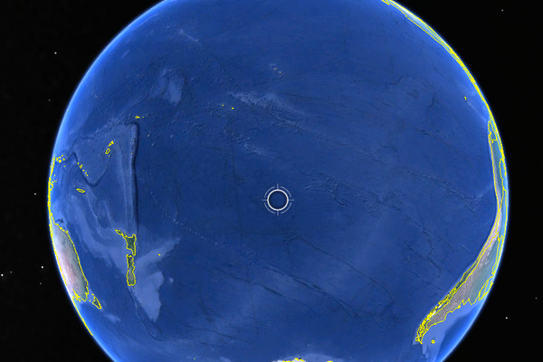
The story actually begins with the work of a different engineer, Brian McClendon, who was a co-founder of the company that eventually became the basis of Google Earth. McClendon was a Jayhawk through and through, and set the default location of Google Earth on PCs to center on his childhood home in Lawrence, Kansas, due to its relative proximity to the geographic center of the continental United States. Not to be outdone, Webb, a fellow Kansan who headed the Mac team, directed Google Earth to center instead on his hometown of Chanute.

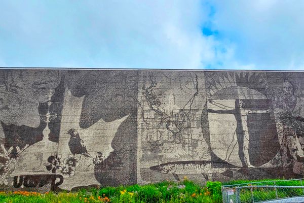
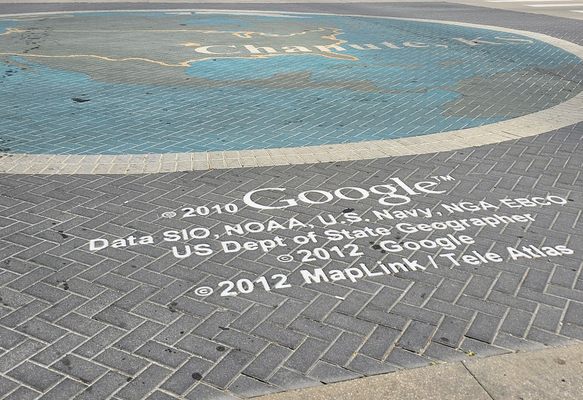
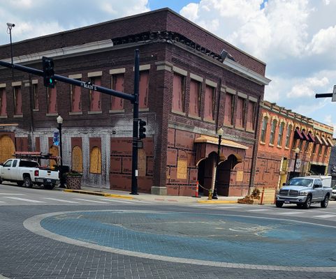
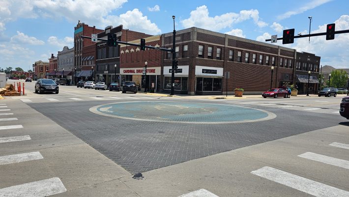
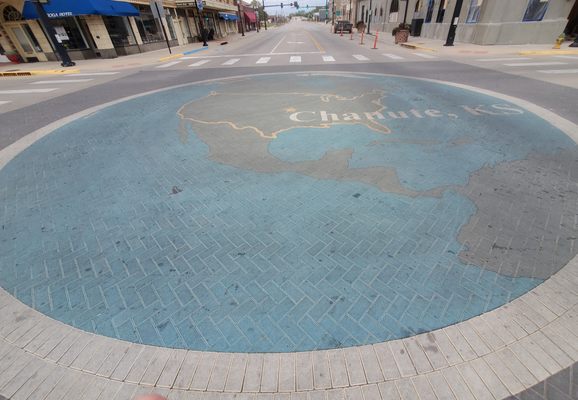
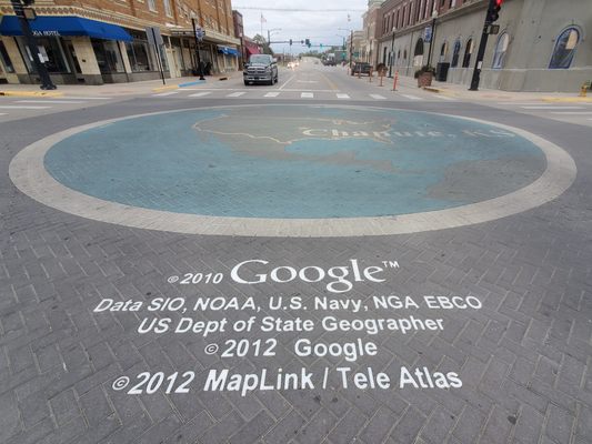
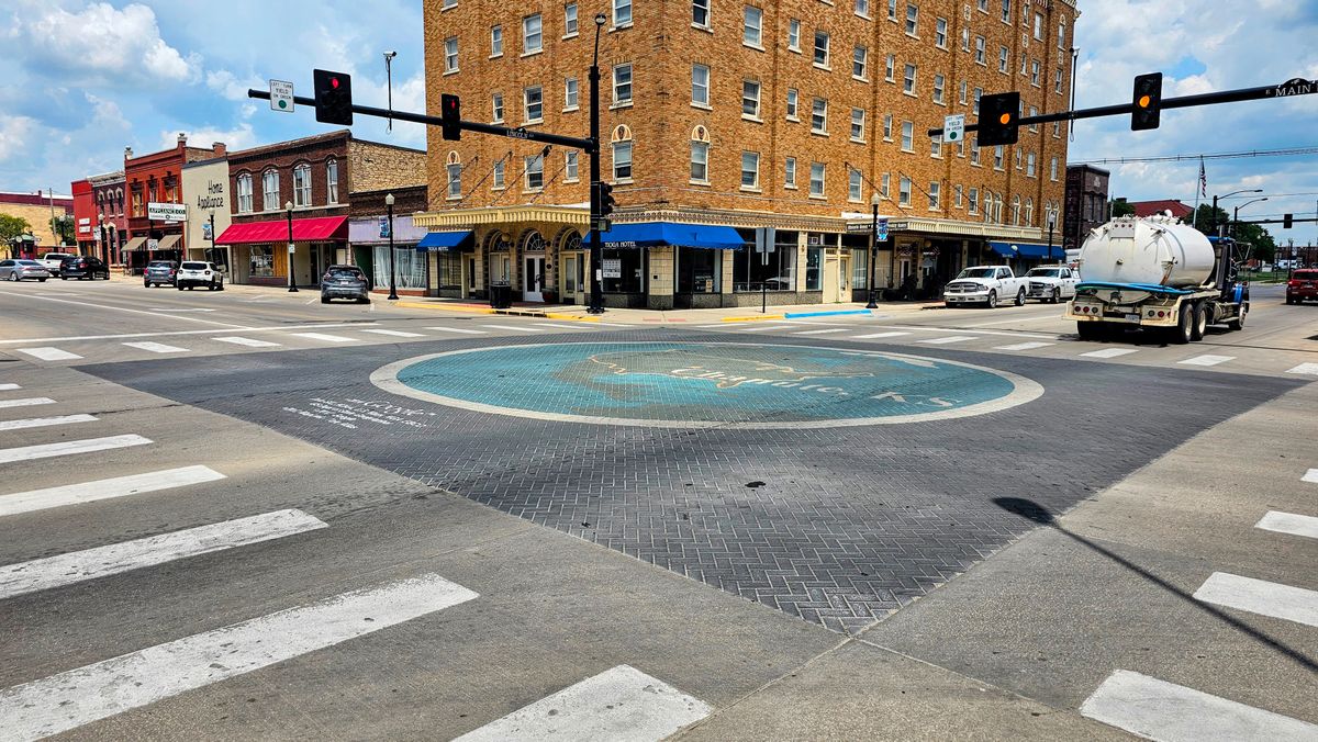
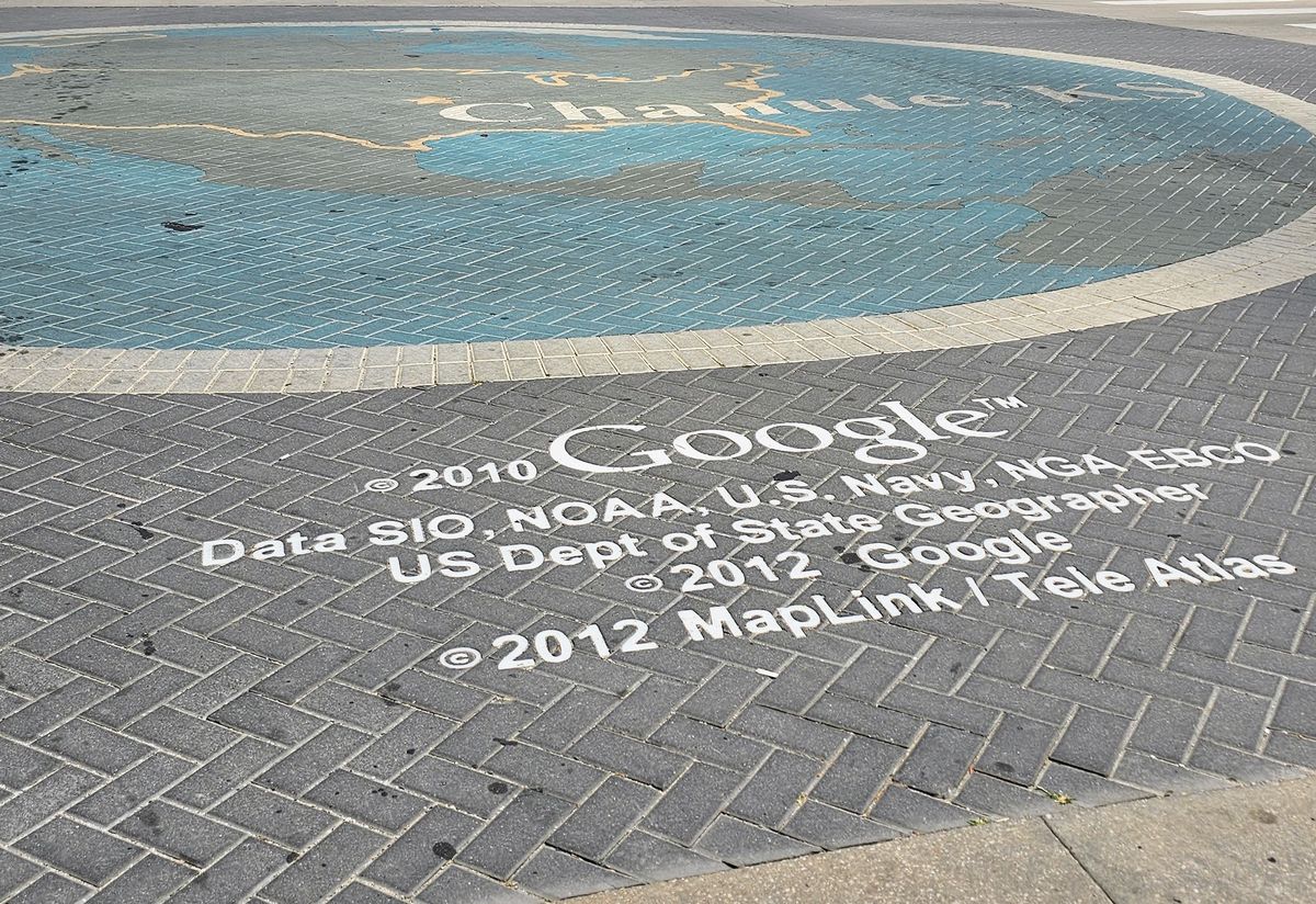
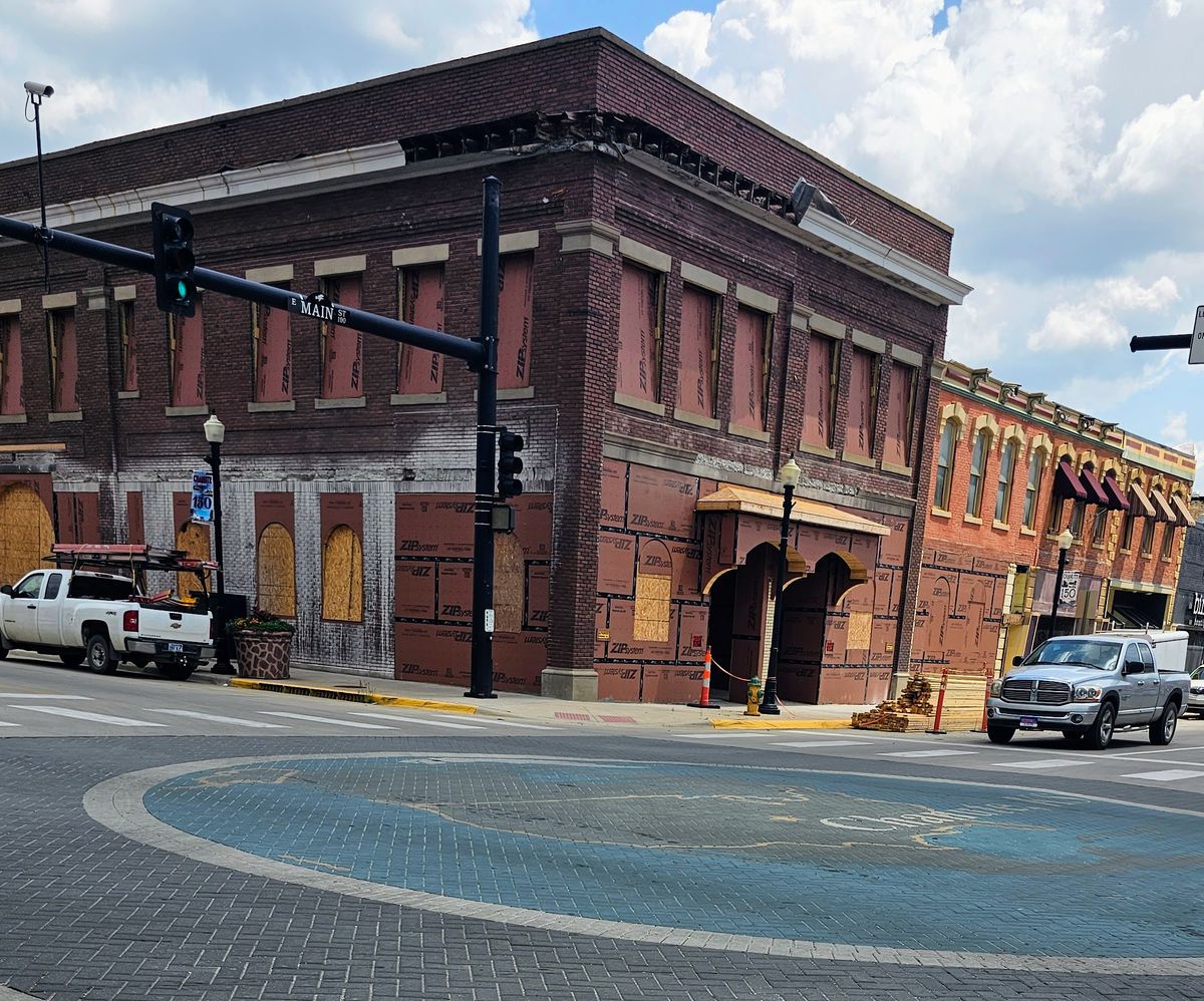
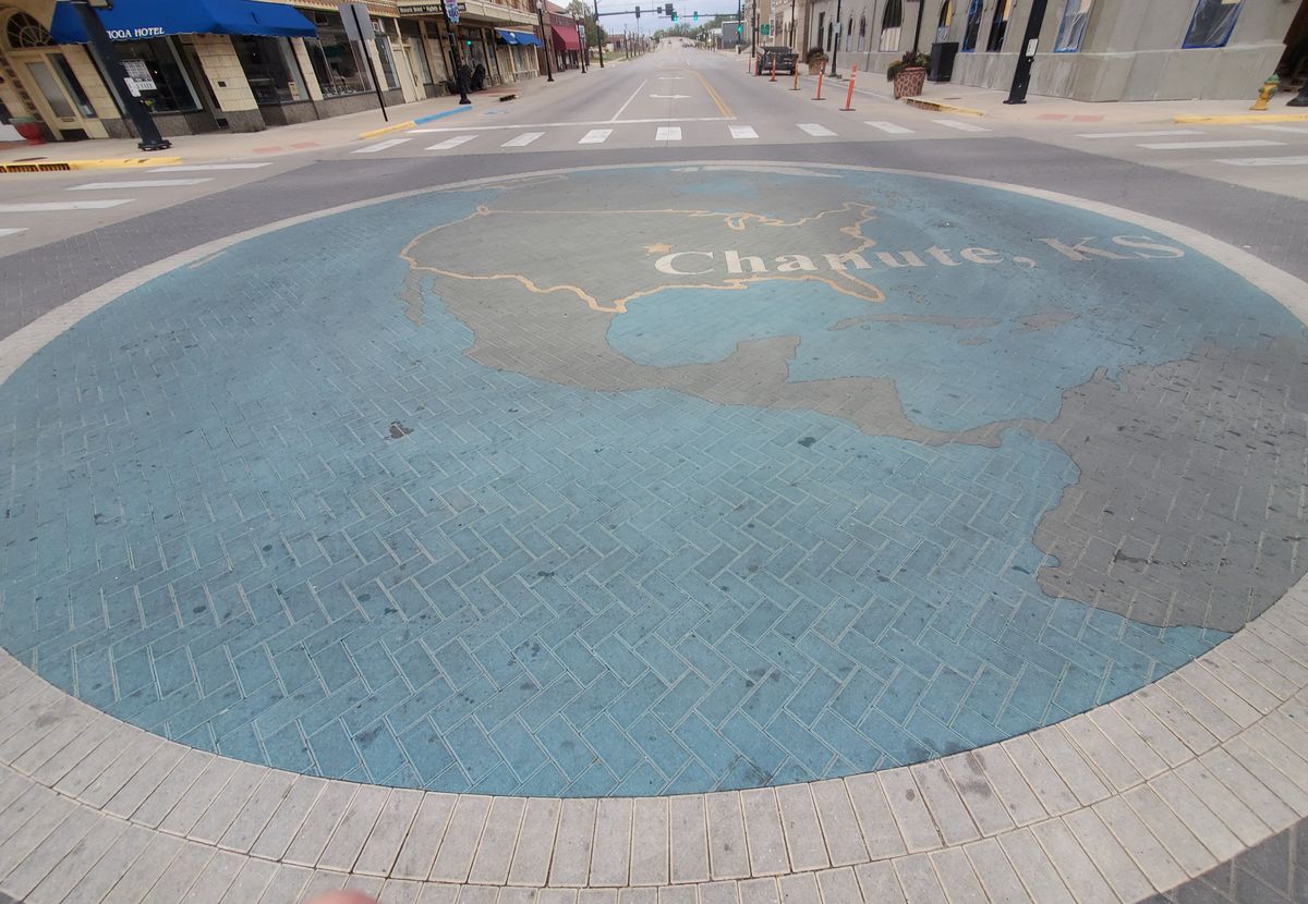
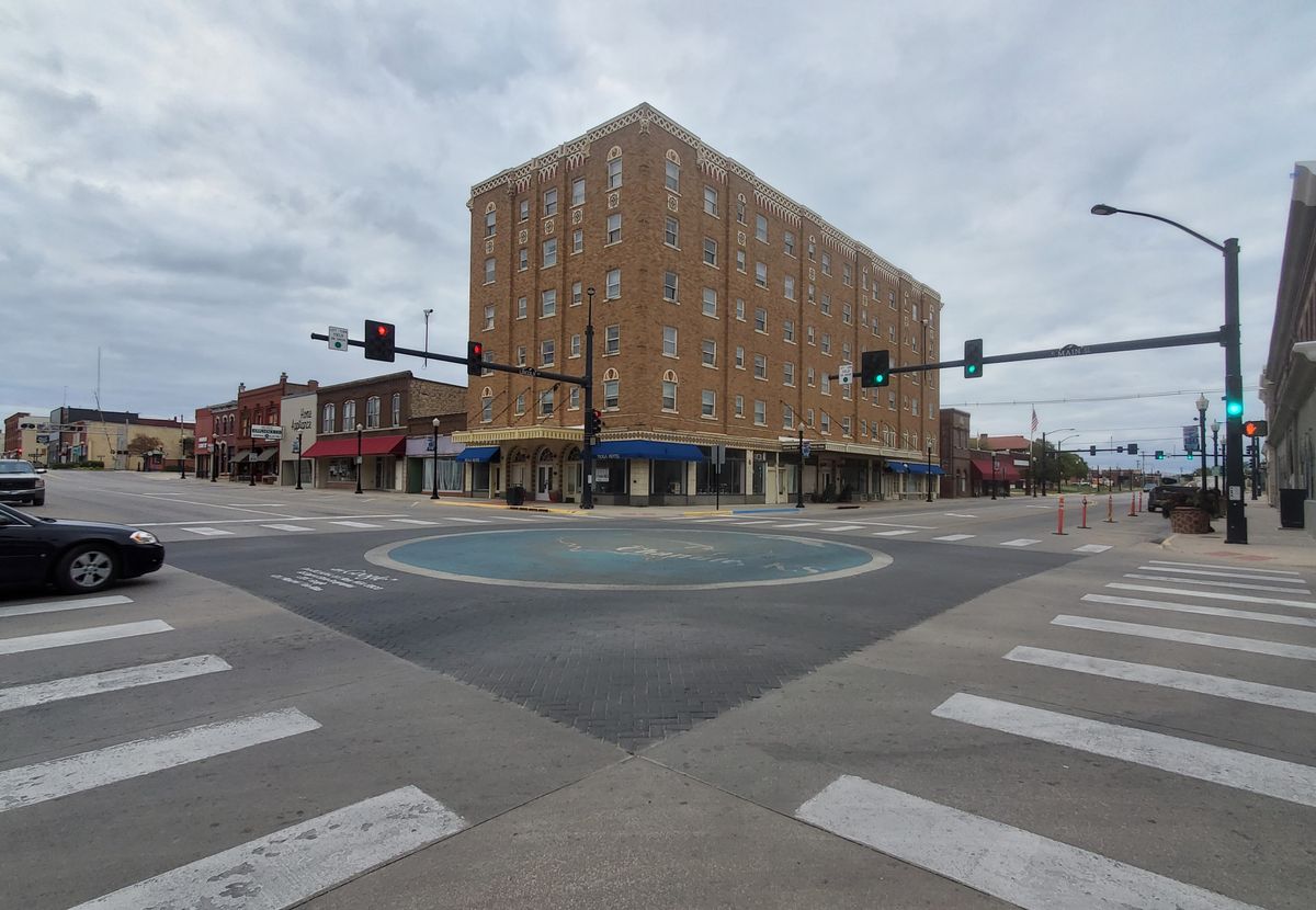
Ordinarily that’s where this anecdote would end, as it did in Lawrence, with an article in the paper and a cute Easter egg for aficionados. But Chanute took this claim to fame fiercely to heart, and created what may be the world’s most permanent screenshot. In 2010, the Chanute Area Chamber of Commerce commissioned a mural of the Google Earth display on Mac computers, and installed it in the center of the town’s busiest intersection. The map includes an outline of the United States of America, a giant star with Chanute, Kansas highlighted in the center, and a copyright verifying the screenshot.

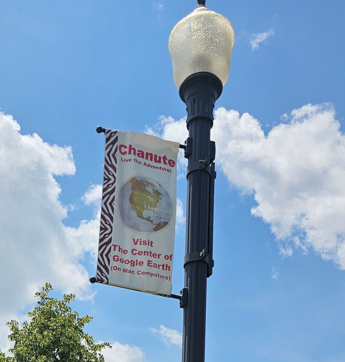
Of course, Google Earth has long since stopped defaulting to any single central location, and would not likely choose such an Amero-centric center point even if it did. However, the mural is still on display today, and banners displayed elsewhere in town make clear that Chanute is the center of Google Earth (on Mac computers). You can visit the mural when you’re in town, and if you’re not able to make it? Don’t worry. The mural is still visible on Google Earth.

Related Tags

Technology Geographic Oddities Geographic Markers Google Maps Maps Murals

Community Contributors

Added By

ianlefk

Edited By

Darrell Powers

  • Darrell Powers

Published

September 22, 2023

Edit this listing

Make an Edit
Add Photos
Sources
  • Bernard Neyer, resident of Chanute for over 42 years, real estate investor and developer.
  • https://clui.org/ludb/site/google-center-usa-mac
  • http://googlemac.blogspot.com/2006/12/why-chanute.html
  • https://www2.ljworld.com/news/2005/dec/21/lawrence_pinpointed_center_google_earth
Center of Google Earth Mural
N Lincoln Ave
Chanute, Kansas, 66720
United States
37.681774, -95.451776
Visit Website
Get Directions

Nearby Places

Chanute-Wright Brothers Memorial

Chanute, Kansas

miles away

Martin and Osa Johnson Safari Museum

Chanute, Kansas

miles away

Sad Saga of Vegetarian Creek

Humboldt, Kansas

miles away

Explore the Destination Guide

Photo of Chanute

Chanute

Kansas

Places 3

Nearby Places

Chanute-Wright Brothers Memorial

Chanute, Kansas

miles away

Martin and Osa Johnson Safari Museum

Chanute, Kansas

miles away

Sad Saga of Vegetarian Creek

Humboldt, Kansas

miles away

Explore the Destination Guide

Photo of Chanute

Chanute

Kansas

Places 3

Related Places

  • Ras Angela

    Ras Angela, Tunisia

    Ras Angela

    The northernmost point of continental Africa—or is it?

  • Sign for L13

    Mannheim, Germany

    Mannheim Quadratestadt

    In this German city center, the streets have no names.

  • A PIRATA weather buoy, the only thing that is really at Null Island.

    Null Island

    A busy island at the center of the world that doesn’t actually exist.

  • Mason-Dixon survey stone.

    Delmar, Maryland

    Transpeninsular Midpoint Marker

    The stone marker that Mason and Dixon placed at the eastern end of the famous north-south border they surveyed.

  • Tucson, Arizona

    Cherrybell Stravenue

    A rare wayfinding portmanteau of “Street” and “Avenue.”

  • The monument’s front.

    East Liverpool, Ohio

    The Starting Point of the U.S. Public Land Survey

    After covering almost 1.5 billion acres, the survey's still not finished.

  • Point Nemo

    Antarctica

    Point Nemo

    At the point of oceanic inaccessibility, you can't get farther from dry land without leaving the planet.

  • The ‘E Pluribus Unum’ Mural at the University of Wisconsin-Stevens Point campus.

    Stevens Point, Wisconsin

    ‘E Pluribus Unum’ Mural

    This massive 286,200-tile mosaic was the largest mural of its kind in the United States and is an early example of computer-generated art.

Aerial image of Vietnam, displaying the picturesque rice terraces, characterized by their layered, verdant fields.
Atlas Obscura Membership

Become an Atlas Obscura Member


Join our community of curious explorers.

Become a Member

Get Our Email Newsletter

Follow Us

Facebook YouTube TikTok Instagram Pinterest RSS Feed

Get the app

Download the App
Download on the Apple App Store Get it on Google Play
  • All Places
  • Latest Places
  • Most Popular
  • Places to Eat
  • Random
  • Nearby
  • Add a Place
  • Stories
  • Food & Drink
  • Itineraries
  • Lists
  • Video
  • Podcast
  • Newsletters
  • All Trips
  • Family Trip
  • Food & Drink
  • History & Culture
  • Wildlife & Nature
  • FAQ
  • Membership
  • Feedback & Ideas
  • Community Guidelines
  • Product Blog
  • Unique Gifts
  • Work With Us
  • About
  • FAQ
  • Advertise With Us
  • Advertising Guidelines
  • Privacy Policy
  • Cookie Policy
  • Terms of Use
Atlas Obscura

© 2025 Atlas Obscura. All Rights Reserved.