Behold a Glorious Vintage Map of Yosemite National Park
Can you find your favorite spots in this 85-year-old artistic map?
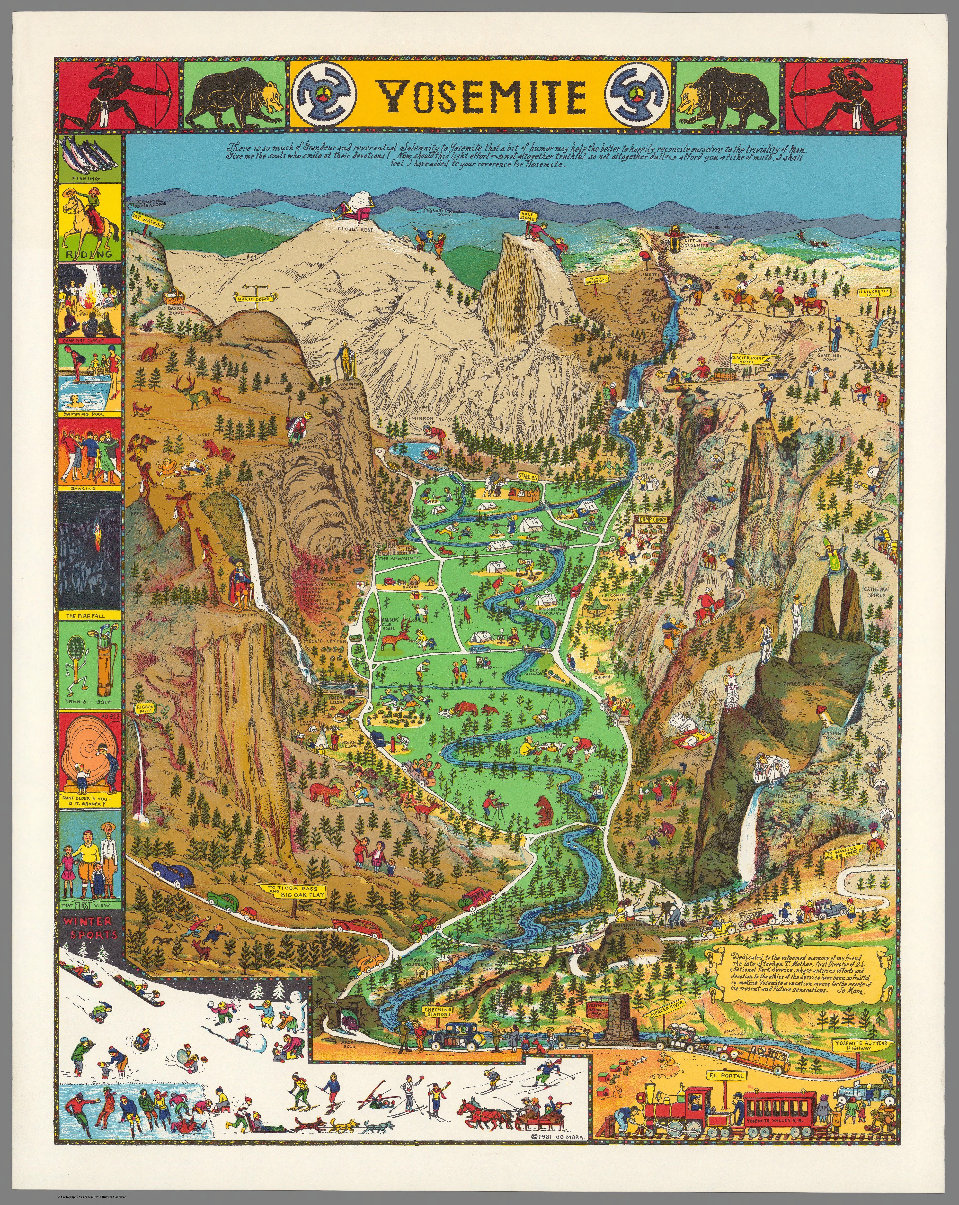
Yosemite, 1931. (Photo: Joseph Mora/Part of the David Rumsey Map Collection)
Yosemite National Park is almost impossible to visualize in its entirety, with its 747,956 acres of mountains, rivers, forests, and myriad species galavanting about, or eating each other.
Imagine a map that gathers all that geographical wonder in one place. It exists in Joseph Mora’s 1931 cartographic homage to the great and treasured national park in California. It’s a colorful, humorous and eccentric mapping of Yosemite in all its glory.

“There is so much grandeur and reverential solemnity to Yosemite that a bit of humor may help the better to happily reconcile ourselves to the triviality of man,” Mora wrote at the top of his artwork.

The map portrays every element that figures into a trip to Yosemite. The arrival by train or by car. Passage into the park’s grounds, advice from local rangers, the camp sites, and the wide range of activities on offer for adventurous tourists.
Summer and winter pursuits are illustrated in small cartoons along the left-hand border, and along the bottom, with lively scenes of riding, tennis, dancing, skiing and swimming. The map is, by the admission of its creator, not entirely truthful, and offers a “tithe of mirth” to enhance the reader’s reverence for Yosemite.
The bottom left-hand side of the map imagines a family’s jaw-dropping repose after their first look at the national park’s stunning scenery.

The main body of the piece shows key monuments and significant sites, from the valley floor up to the park’s highest peaks, like the famous “Cloud’s Rest.” Mora, a Uruguayan-born artist who became famous for his artistic maps, has a comic and literal take on many of these.
It’s even possible to play a game akin to “Where’s Waldo” with your favorite Yosemite locations. There is a person staring at their reflection in “Mirror Lake.” George Washington stands atop “Washington Column.” And a woman in a white wedding dress lingers over “Bridal Veil Falls.” These cartoons are repeated across the map.

Stephen Mather founded the National Park Service 100 years ago last week, on August 25, 1916. This map was dedicated to him after his death in 1930.
An inscription on the bottom right-hand corner of the map thanks Mather, “whose untiring efforts and devotion to the ethics of the Service have been so fruitful in making Yosemite a vacation mecca for the people of the present and future generations.”

Stephen Mather, founded the National Park Service in 1916. (Photo: Marian Albright Schenk/Public domain)
Charming scenes play out in different parts of the map. A man takes a photograph of a bear, a fisherman falls asleep by a river and a mother attends to a crying child. Elsewhere a man looks through binoculars, a family descends the train at El Portal, and a couple hug and gaze over “Inspiration Point.”
The center of the map shows how families camped along the valley floor. Deer, fox and bear eat or scavenge for food. There are more than 400 animal species at Yosemite.

Humans have lived in the area that became Yosemite National Park for thousands of years. Until the late 18th century, the Miwok people were its main inhabitants. The first non-Indians to venture into the region were a government-backed militia group, who were there on the pretext of taking control of the Fresno River Reservation.
On countless occasions militia groups, and the army, tried to remove Indians from their land, killing many. These missions were, however, largely unsuccessful in the early days. The state of California took control of Yosemite in 1864 and Galen Clark, a man who had spent time alone in the park and an expert on the local flower and fauna, became its first guardian two years later.
 A view over Yosemite National Park. (Photo: Dimitry B/CC SA: BY 2.0)
At the turn of the 20th century, after the California gold rush had brought many people to the area, the number of Indians decreased dramatically. Thousands were killed, died of starvation or forced to relocate. The National Park Service razed the last Yosemite Indian village in 1969, according to the National Park Service. In the 20th century, Yosemite became a popular destination for tourists and naturalists alike.
The park is famous for its waterfalls and rock formations, and both feature prominently in Mora’s creation. Water descends the Nevada Falls, drawn on the top right-hand corner, down through Vernal Falls and forms a river across the valley floor. And the 3,000-foot “El Capitan” appears on the opposite corner, whose steep Dawn Wall was scaled by a free-climber for the first time in history in 2015.
Mora’s map is now part of the David Rumsey Map Collection.
Map Monday highlights interesting and unusual cartographic pursuits from around the world and through time. Read more Map Monday posts.
Update, 9/2: An earlier version of this story incorrectly stated that El Capitan was first scaled by a rock-climber in 2015. This was the first time the Dawn Wall had been scaled by a free-climber. We regret the error.


Follow us on Twitter to get the latest on the world's hidden wonders.
Like us on Facebook to get the latest on the world's hidden wonders.
Follow us on Twitter Like us on Facebook