Trips Places Foods Stories Newsletters
Loading...
Loading...
Loading...
Loading...

No search results found for
“”

Make sure words are spelled correctly.

Try searching for a travel destination.

Places near me Random place

Popular Destinations

  • Paris
  • London
  • New York
  • Berlin
  • Rome
  • Los Angeles
Trips Places Foods Stories Newsletters
Sign In Join
Places near me Random place
All the United States Vermont Stowe Mount Mansfield

Mount Mansfield

The highest peak in the state of Vermont has some interesting features.

Stowe, Vermont

Added By
Thomas Harper
Email
Been Here
Want to go
Added to list
CAPTION
Mount Mansfield   Wikipedia user Redjar
View from Mount Mansfield   thomasharper / Atlas Obscura User
The Chin of Mount Mansfield   thomasharper / Atlas Obscura User
Been Here
Want to go
Added to list

About

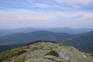
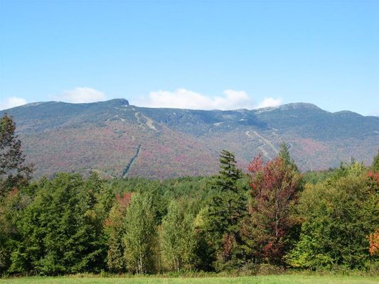
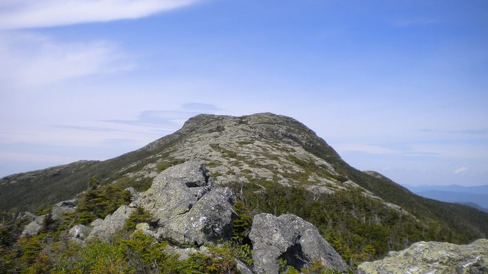
Seen from the east or west, Mount Mansfield looks like a human face laying horizontally, with peaks at the forehead, nose, lip, chin, and Adam's apple. "The Chin" is the highest point in Vermont at 4,393 feet above sea level.

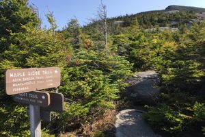
Some of the only alpine tundra in the eastern United States is along the ridgeline of Mount Mansfield. To protect this terrain, all trails are closed during the New England mud season, from mid-April to around Memorial Day. The winters see punishing snowstorms on the mountaintop and ample skiing on its slopes. Summer and autumn provide access to many different trails to the summit and vibrant colors in the surrounding forests.

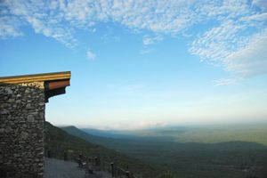
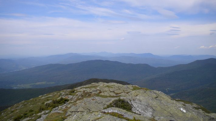
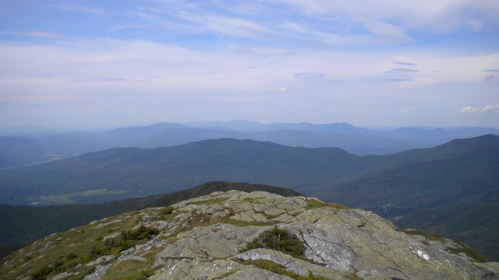
The simplest way to ascend to Vermont's highest point is to drive up the Mount Mansfield Toll Road--look for "Stowe Auto Toll Road" signs off Route 108--to the Visitors Center just underneath the nose (the Philtrum) and hike 1.3 miles along the ridgeline via the Long Trail past the lip and then to the chin. A wide view is presented, and on a clear day, you can see Lake Champlain and the Adirondack Mountains of New York.

Related Tags

Geographic Markers State High Points Mountains

Know Before You Go

Understand that this drive is available only in warm weather months, and the toll road to the top usually will open on 1 June, and usually will close in October. Drive up the Mount Mansfield Auto Toll Road--look for the "Stowe Auto Roll Road" signs off Route 108--to the Visitors Center and hike 1.3 miles on the Long Trail to the summit at the Chin.

Community Contributors

Added By

thomasharper

Edited By

Rachel, rugby007

  • Rachel
  • rugby007

Published

May 7, 2013

Edit this listing

Make an Edit
Add Photos
Sources
  • http://www.stowe.com/activities/summer/auto-toll-road/
  • http://en.wikipedia.org/wiki/Mount_Mansfield
  • http://www.summitpost.org/mount-mansfield/150938
  • Stowe Auto Toll Road: https://www.stowe.com/explore-the-resort/activities-and-events/auto-toll-road.aspx
Mount Mansfield
Stowe, Vermont, 05672
United States
44.543663, -72.81429
Visit Website

Nearby Places

Wampahoofus Trail

Underhill, Vermont

miles away

Trapp Family Lodge

Stowe, Vermont

miles away

'Snowflake' Bentley Exhibit

Jericho, Vermont

miles away

Explore the Destination Guide

Photo of Stowe

Stowe

Vermont

Places 3

Nearby Places

Wampahoofus Trail

Underhill, Vermont

miles away

Trapp Family Lodge

Stowe, Vermont

miles away

'Snowflake' Bentley Exhibit

Jericho, Vermont

miles away

Explore the Destination Guide

Photo of Stowe

Stowe

Vermont

Places 3

Related Stories and Lists

The Most Wondrous State Parks to Visit During the Government Shutdown

List

By Kerry Wolfe

The Highest Places in America

List

By Meg Neal

The Summit Scaling Subculture of Highpointing

geographic markers

By Thomas Harper

Related Places

  • Mount Denali

    Denali National Park and Preserve, Alaska

    Denali

    The king of U.S. high points towers over every other peak on the continent.

  • Mount Rainier

    Ashford, Washington

    Mount Rainier

    The highest point in Washington state is a volcano covered in glaciers.

  • Gannett Peak

    Cora, Wyoming

    Gannett Peak

    The easiest way to the highest point in Wyoming is only accessible via one hefty fee.

  • Mount Hood

    Government Camp, Oregon

    Mount Hood

    Despite a legend that says this highest peak in Oregon was climbed in high heels, scores of people have died on its slopes.

  • Granite Peak

    Granite Peak

    The highest point in Montana is as rugged and singular as the state itself.

  • Borah Peak

    Mackay, Idaho

    Borah Peak

    This highest peak in Idaho can only be reached by traversing a formation known as "Chicken-Out Ridge."

  • Kings Peak

    Duchesne County, Utah

    Kings Peak

    The highest peak in Utah is the hardest to reach, but only if explorers choose the hard way.

  • The left peak is Boundary Peak

    Dyer, Nevada

    Boundary Peak

    The highest point in Nevada had to be decided by court order after California tried to claim it as their own.

Aerial image of Vietnam, displaying the picturesque rice terraces, characterized by their layered, verdant fields.
Atlas Obscura Membership

Become an Atlas Obscura Member


Join our community of curious explorers.

Become a Member

Get Our Email Newsletter

Follow Us

Facebook YouTube TikTok Instagram Pinterest RSS Feed

Get the app

Download the App
Download on the Apple App Store Get it on Google Play
  • All Places
  • Latest Places
  • Most Popular
  • Places to Eat
  • Random
  • Nearby
  • Add a Place
  • Stories
  • Food & Drink
  • Itineraries
  • Lists
  • Video
  • Podcast
  • Newsletters
  • All Trips
  • Family Trip
  • Food & Drink
  • History & Culture
  • Wildlife & Nature
  • FAQ
  • Membership
  • Feedback & Ideas
  • Community Guidelines
  • Product Blog
  • Unique Gifts
  • Work With Us
  • About
  • FAQ
  • Advertise With Us
  • Advertising Guidelines
  • Privacy Policy
  • Cookie Policy
  • Terms of Use
Atlas Obscura

© 2025 Atlas Obscura. All Rights Reserved.