About
Early aircraft navigation was primitive. Traveling through the skies mostly relied on visual landmarks on the ground.
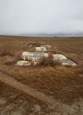
With the dawning of airmail service in the 1920s, improvements became highly desirable, and this led to the construction of a continent-spanning network of concrete navigational arrows pointing in the correct direction for planes to follow.
Originally, each arrow was accompanied by a tower with a beacon. This allowed planes flying at night the ability to follow a course from light to light. Most of the towers have long since been salvaged for scrap, but a remarkable number of arrows remain. Most are remote and hard to reach, but this one is just off Interstate 80 on the west side, about 10 miles northeast of Lovelock, Nevada.
Related Tags
Know Before You Go
The arrow is just off the frontage road on the west side of I-80.
To reach this road, take Nevada State Route 396 (U.S. Business 95, Upper Valley Road) north from Lovelock from its intersection at 14th St. Keep going straight at 6 miles where NV 396 turns right.
In another 4.3 miles the frontage road, which has become the Poker Brown Camp Road, makes a right-angle bend to the west. Park just past this bend on the right; the arrow is off the road about 20 yards.
Alternatively, you can pick up the frontage road from I-80 at Exit 112. Go 1/4 mile west, turn right on the frontage road and proceed as above. The arrow also shows up plainly on Google satellite photos.
Community Contributors
Added By
Published
June 23, 2022

