Trips Places Foods Stories Newsletters

Take your next trip with Atlas Obscura!

Our small-group adventures are inspired by our Atlas of the world's most fascinating places, the stories behind them, and the people who bring them to life.

Visit Adventures
Trips Highlight
Macchu Picchu
Peru • 10 days, 9 nights
Peru: Machu Picchu & the Last Incan Bridges
from
Central Asia yurt night stars
Uzbekistan • 15 days, 14 nights
Central Asia Road Trip: Backroads & Bazaars
from
View all trips
Top Destinations
Latest Places
Most Popular Places Random Place Lists Itineraries
Add a Place
Download the App
Top Destinations
View All Destinations Â»

Countries

  • Australia
  • Canada
  • China
  • France
  • Germany
  • India
  • Italy
  • Japan

Cities

  • Amsterdam
  • Barcelona
  • Beijing
  • Berlin
  • Boston
  • Budapest
  • Chicago
  • London
  • Los Angeles
  • Mexico City
  • Montreal
  • Moscow
  • New Orleans
  • New York City
  • Paris
  • Philadelphia
  • Rome
  • San Francisco
  • Seattle
  • Stockholm
  • Tokyo
  • Toronto
  • Vienna
  • Washington, D.C.
Latest Places
View All Places Â»
Shadow Room
The Museum of Lost Tales
Sherlock Holmes Statue
South Pole Growth Chamber
Pasties are an Upper Michigan tradition dating back to mining days.
Lehto’s Pasties
Latest Places to Eat & Drink
View All Places to Eat »
Pasties are an Upper Michigan tradition dating back to mining days.
Lehto’s Pasties
Stock up on picnic supplies with a side of history.
Horton Bay General Store
Take some of Michigan’s produce home with you.
American Spoon
The local catch is delicious fried as well.
Terry's of Charlevoix
Carlson’s Fishery is a Great Lakes institution.
Carlson’s Fishery
Recent Stories
All Stories Video Podcast
Most Recent Stories
View All Stories »
Here’s which treats you can safely lug home without risking a fine.
Dear Atlas: What International Food Can I Legally Bring Into the U.S.?
Cely’s map is not only accurate, but captures the unique characteristics of Congaree’s trees and waterways.
How One Biologist Drew a Hyper-Accurate, Ranger-Approved Map of Congaree National Park
Though they’re protected inside the park, wolves can be killed when they cross its borders.
Wolves Have a Bad Reputation. One Yellowstone Naturalist Is Trying to Fix It.
The community board at Rex’s Dino Store advertises all kinds of NYC-specific dino services.
We Visited the Dino Bodega in (Jurassic) Park Slope

No search results found for
“”

Make sure words are spelled correctly.

Try searching for a travel destination.

Places near me Random place

Popular Destinations

  • Paris
  • London
  • New York
  • Berlin
  • Rome
  • Los Angeles
Trips Places Foods Stories Newsletters
Sign In Join
Places near me Random place
All Spain Madrid Juan de la Cosa Map
AO Edited

Juan de la Cosa Map

The earliest known map to show America, discovered by accident at a Paris bookshop.

Madrid, Spain

Added By
Annetta Black
Email
Been Here
Want to go
Added to list
CAPTION
Detail of map   http://upload.wikimedia.org/wikipedia/comm...
Juan de la Cosa mappa mundi   http://en.wikipedia.org/wiki/File:1500_map...
Juan de la Cosa   http://enciclopedia.us.es/index.php/Juan_d...
De la Cosa’s ship, Santa Maria displayed in the Naval Museum in Madrid   Luis Morato / Atlas Obscura User
Bizarre beings were supossed to lived in unknown places   Luis Morato / Atlas Obscura User
1500 map by Juan de la Cosa - India   Juan de la Cosa, Public domain, via Wikimedia Commons
The ethiopian monarch imagined by De La Cosa   Luis Morato / Atlas Obscura User
Hispaniola is depicted in De la Cosa’s map   Luis Morato / Atlas Obscura User
Been Here
Want to go
Added to list

About

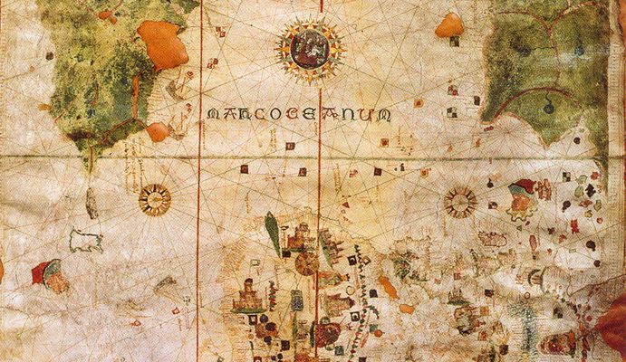
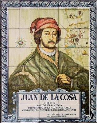
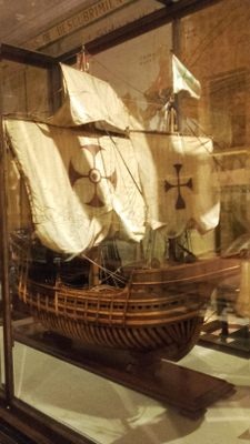
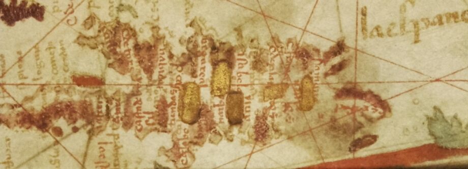
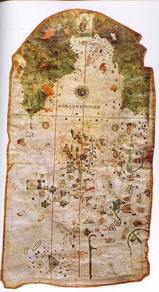
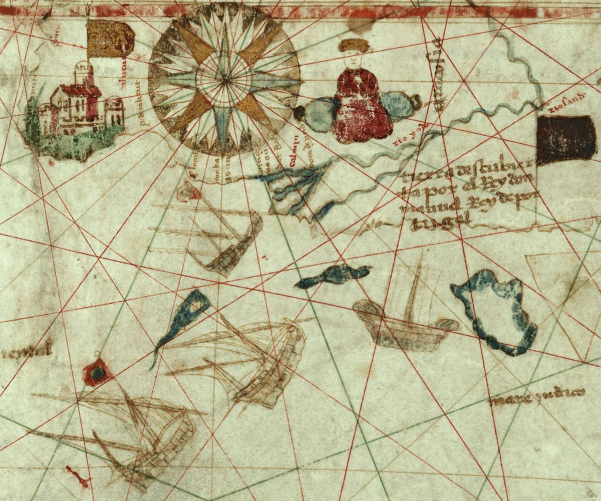
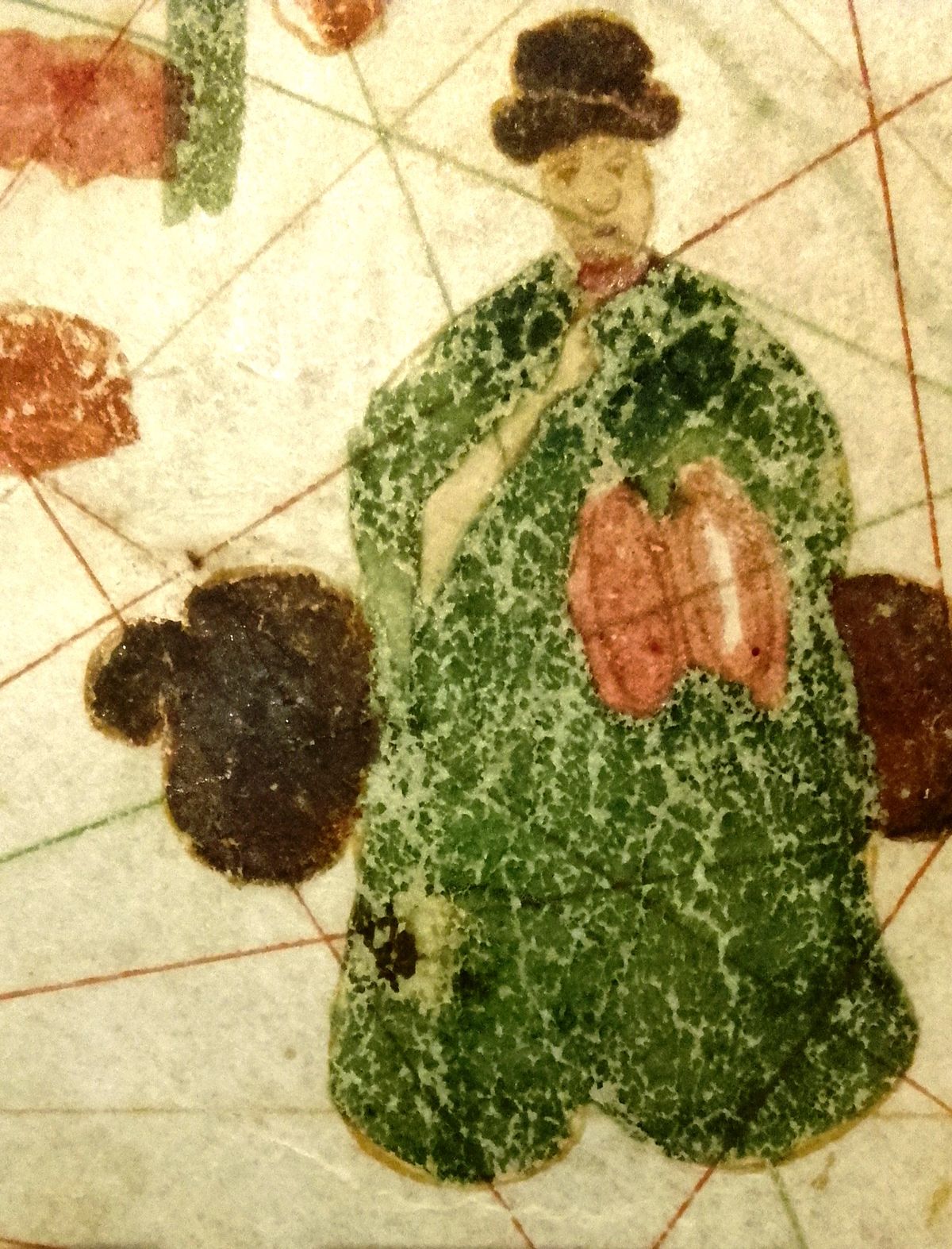
Although Columbus was a mapmaker in his pre-expedition days, he left behind no known maps of his explorations. Luckily for us, Juan de la Cosa, who sailed with Columbus on three journeys, did - leaving us with the oldest known map showing America.

De la Cosa was the captain of the Santa Maria, and later, after she was shipwrecked, the master of the Marigalante, and finally sailed on La Nina. He also "explored" (and with the brutal conquistadors conquered the indigenous inhabitants) the lands of Colombia and Panama with Vasco Nunez de Balboa. He returned to Spain with his famous map, but died in the New World after being fatally shot by indigenous peoples (who his group had previously attacked)  with poisoned arrows in Turbaco, Colombia in 1509.

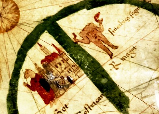
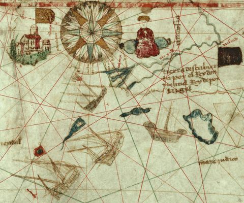
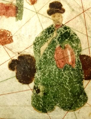
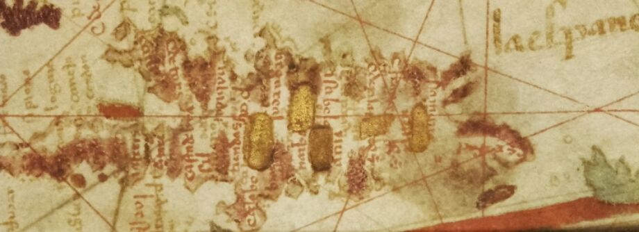
Drawn in or around the year 1500, this early style of map is known as a "mappa mundi" or "world map." Maps like this were highly valuable pieces of maritime information, each new map adding to the store of knowledge that kept ships from wrecking on uncharted hazards. They were also closely guarded state secrets, as they held the keys for one nations superiority over another in maritime trade and colonialism.

De la Cosa's map incorporates older information as well as the recent voyages of Vasco de Gama to India in 1498. Drawn on ox-hide, it measures 72" x 37 1/2".

The map was unknown before 1832 when it was discovered in a Paris shop by the French scientist and map enthusiast Charles Walckenaer. It is thought that the map had been taken from the Secret Archives at the Vatican in 1810 by Napoleon, and found its way into a bookshop after his fall. After Walckenaer's death in 1853, the map was bought by the queen of Spain, and brought back to Madrid.

In 1839 Walckenaer went on to become the conservator of maps for the Department of Maps at the Royal Library in Paris.

Related Tags

Marvelous Maps And Measures Dead Explorers

Community Contributors

Added By

Annetta Black

Edited By

kerrizor, Monsieur Mictlan, Luis Morato, Xavixavir

  • kerrizor
  • Monsieur Mictlan
  • Luis Morato
  • Xavixavir

Published

June 29, 2010

Edit this listing

Make an Edit
Add Photos
Sources
  • http://www.gomadrid.com/museums/naval-museum.html
  • http://en.wikipedia.org/wiki/Map_of_Juan_de_la_Cosa
  • http://historical-travels.com/2010/01/02/map-of-juan-de-la-cosa/
  • http://www.sochistdisc.org/2003_articles/alvarez.htm
Juan de la Cosa Map
Museo Naval
Paseo del Prado, 5
Madrid, 28014
Spain
40.41752, -3.692802
Visit Website
Get Directions

Nearby Places

Caja de las Letras

Madrid, Spain

miles away

Convent of the Holy Spirit Crypts

Madrid, Spain

miles away

Automatons of the Goyesque Carillon

Madrid, Spain

miles away

Explore the Destination Guide

Photo of Madrid

Madrid

Spain

Places 117
Stories 2

Nearby Places

Caja de las Letras

Madrid, Spain

miles away

Convent of the Holy Spirit Crypts

Madrid, Spain

miles away

Automatons of the Goyesque Carillon

Madrid, Spain

miles away

Explore the Destination Guide

Photo of Madrid

Madrid

Spain

Places 117
Stories 2

Related Places

  • The gallery of maps, showing the ceiling

    Vatican City

    Gallery of Maps - Galleria delle Carte Geografiche

    Breathtaking and huge 430 year old maps of Italy.

  • Florence, Italy

    Medici Hall of Maps (Sala delle Carte Geografiche)

    Over 50 exquisite hand-painted Renaissance maps decorate a Medici storage room.

  • Mercator Globe

    Sint-Niklaas, Belgium

    Mercator Museum

    Housing the groundbreaking maps and globes of Gerard Mercator.

  • Markings on the old bridge

    Heidelberg, Germany

    Hochwassermarken

    Lines on the pillar of Heidelberg's Karl-Theodor Bridge record the dramatic heights of past floods.

  • Vienna Cloth Measures

    Vienna, Austria

    Vienna Cloth Measures

    These two 15th-century metal rods allowed people to check if they were swindled or not.

  • Glasgow, Scotland

    George Square Imperial Measurements

    A small collection of objects of a bygone era hide in plain view.

  • Looking down Cheney Row, with the measurements embedded in the wall

    Sheffield, England

    Sheffield Standard Measures of Length

    Presented to the city in 1910 for public use, these brass markers show varying lengths.

  • Leuven, Belgium

    Leuven Historical Measures

    Though they might seem like arbitrary scratches in the wall, these were once official measures of length.

Aerial image of Vietnam, displaying the picturesque rice terraces, characterized by their layered, verdant fields.
Atlas Obscura Membership

Become an Atlas Obscura Member


Join our community of curious explorers.

Become a Member

Get Our Email Newsletter

Follow Us

Facebook YouTube TikTok Instagram Pinterest RSS Feed

Get the app

Download the App
Download on the Apple App Store Get it on Google Play
  • All Places
  • Latest Places
  • Most Popular
  • Places to Eat
  • Random
  • Nearby
  • Add a Place
  • Stories
  • Food & Drink
  • Itineraries
  • Lists
  • Video
  • Podcast
  • Newsletters
  • All Trips
  • Family Trip
  • Food & Drink
  • History & Culture
  • Wildlife & Nature
  • FAQ
  • Membership
  • Feedback & Ideas
  • Community Guidelines
  • Product Blog
  • Unique Gifts
  • Work With Us
  • About
  • FAQ
  • Advertise With Us
  • Advertising Guidelines
  • Privacy Policy
  • Cookie Policy
  • Terms of Use
Atlas Obscura

© 2025 Atlas Obscura. All Rights Reserved.