Trips Places Foods Stories Newsletters

Take your next trip with Atlas Obscura!

Our small-group adventures are inspired by our Atlas of the world's most fascinating places, the stories behind them, and the people who bring them to life.

Visit Adventures
Trips Highlight
Puglia Italy - Matera
Italy • 8 days, 7 nights
Southern Italy: Castles, Caves & Coastal Treasures in Puglia
from
Turkmenistan Gates of Hell Darvaza crater
Turkmenistan • 10 days, 9 nights
Turkmenistan & the Gates of Hell
from
View all trips
Top Destinations
Latest Places
Most Popular Places Random Place Lists Itineraries
Add a Place
Download the App
Top Destinations
View All Destinations »

Countries

  • Australia
  • Canada
  • China
  • France
  • Germany
  • India
  • Italy
  • Japan

Cities

  • Amsterdam
  • Barcelona
  • Beijing
  • Berlin
  • Boston
  • Budapest
  • Chicago
  • London
  • Los Angeles
  • Mexico City
  • Montreal
  • Moscow
  • New Orleans
  • New York City
  • Paris
  • Philadelphia
  • Rome
  • San Francisco
  • Seattle
  • Stockholm
  • Tokyo
  • Toronto
  • Vienna
  • Washington, D.C.
Latest Places
View All Places »
Pinal Airpark
Note the chrysanthemum crests.
Hachiman Bridge
Clarendon War Memorial.
Clarendon War Memorial
This fried chicken is one of Bangkok’s most famous.
Gai Tord Jae Kee
Latest Places to Eat & Drink
View All Places to Eat »
This fried chicken is one of Bangkok’s most famous.
Gai Tord Jae Kee
Chefs Aruss Lerlerstkull and Atcharaporn Kiatthanawat lean into regional traditions.
Charmgang
The khao soi at Gedhawa comes with a rich, coconutty broth.
Gedhawa
At Nai Mong Hoi Thod, the oyster omelet is worth waiting for.
Nai Mong Hoi Thod
In this deceptively simple dish, top-quality ingredients are paramount.
Kor Panich
Recent Stories
All Stories Video Podcast
Most Recent Stories
View All Stories »
Haleakalā National Park’s summit region, shrouded in the pre-dawn fog.
Beware the Legends Behind These National Park Souvenirs
5 days ago
For Aguilar-Carrasco, nature is a powerful reminder of the interconnectedness of all life.
How Can National Parks Be Made Accessible to All? AO Wants to Know.
6 days ago
Podcast: Finding ‘The Great Gatsby’ in Louisville
7 days ago
Here’s which treats you can safely lug home without risking a fine.
Dear Atlas: What International Food Can I Legally Bring Into the U.S.?
8 days ago

No search results found for
“”

Make sure words are spelled correctly.

Try searching for a travel destination.

Places near me Random place

Popular Destinations

  • Paris
  • London
  • New York
  • Berlin
  • Rome
  • Los Angeles
Trips Places Foods Stories Newsletters
Sign In Join
Places near me Random place
All the United States Utah Moab Tusher Tunnel
AO Edited

Tusher Tunnel

A crack flared at the base provides a pathway completely through a sandstone ridge near Moab.

Moab, Utah

Added By
slgwv
Email
Been Here
Want to go
Added to list
Near the entrance to Tusher Tunnel, Moab Area, UT   Glenn Merritt
Tusher Tunnel. The tunnel is tall enough to stand upright–note the shadowed figure.   slgwv / Atlas Obscura User
Tusher Tunnel.   slgwv / Atlas Obscura User
View back toward the west portal of the tunnel.   slgwv / Atlas Obscura User
View near the east portal of Tusher Tunnel.   slgwv / Atlas Obscura User
View from the west portal of the tunnel.   slgwv / Atlas Obscura User
View south from the west portal.   slgwv / Atlas Obscura User
Tusher Tunnel.   slgwv / Atlas Obscura User
Been Here
Want to go
Added to list

About

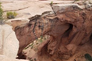
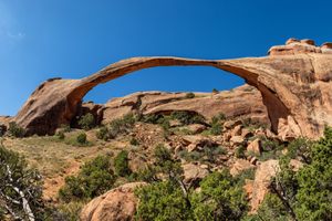
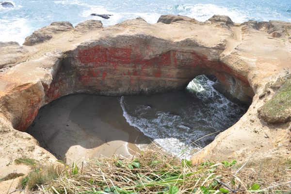
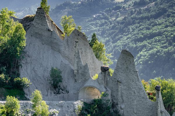
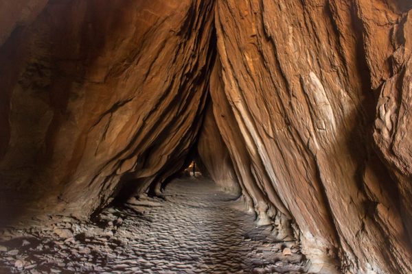
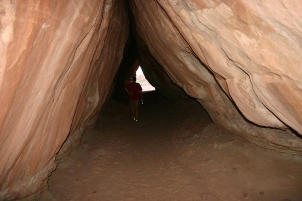
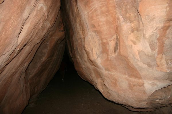
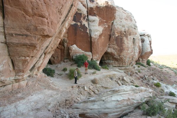
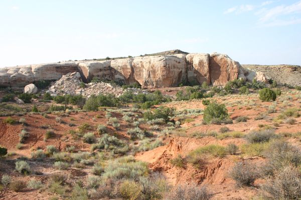
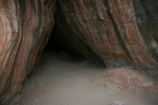
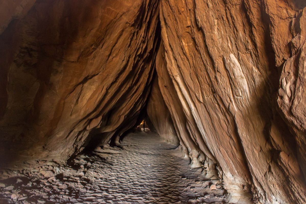
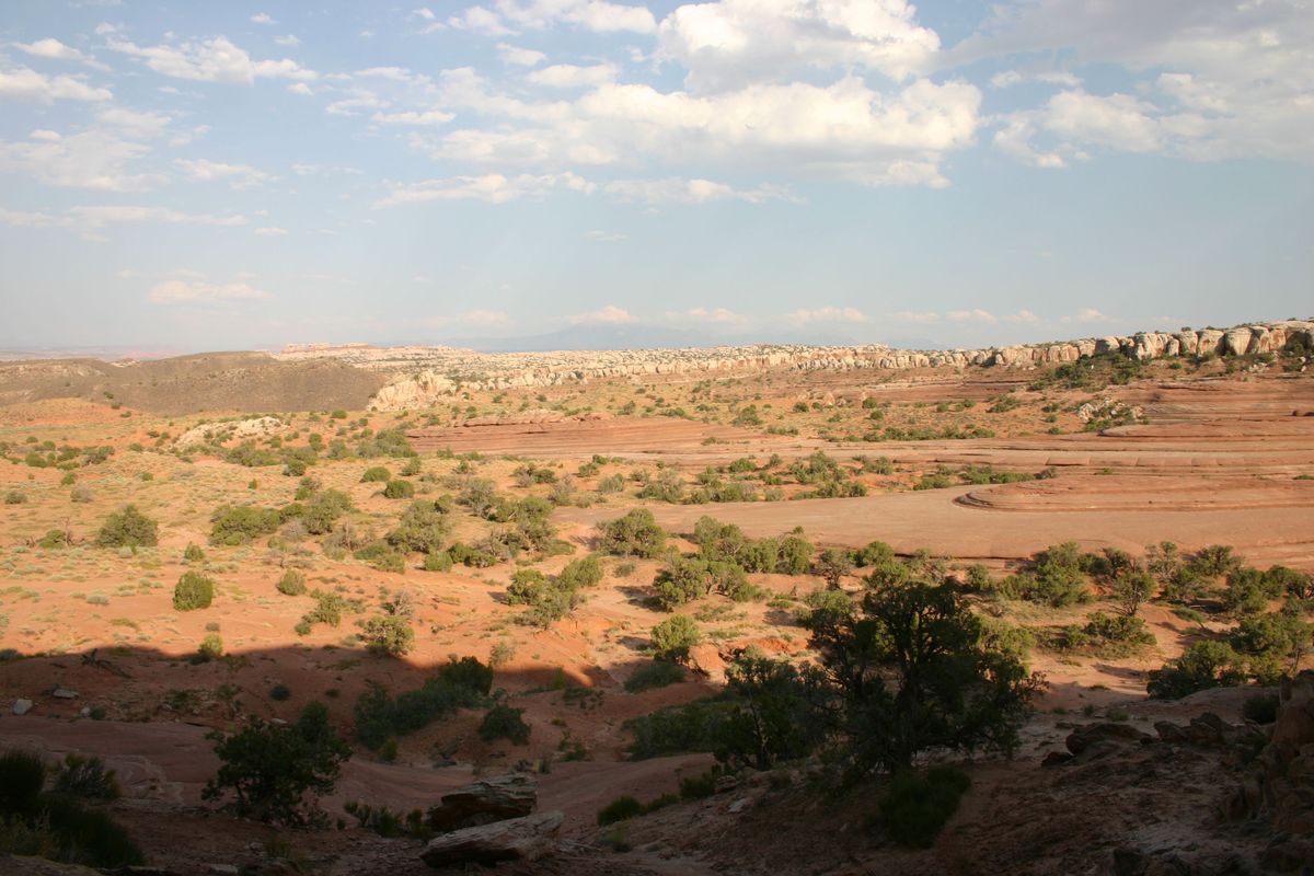
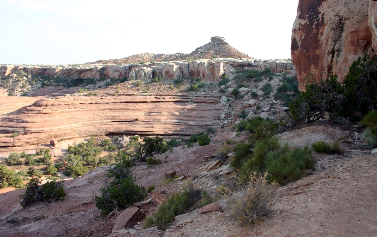
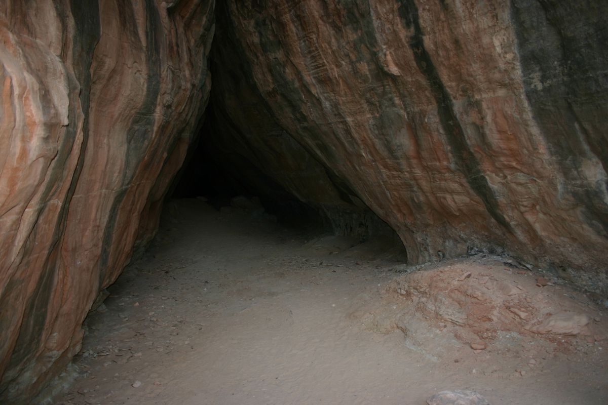
Tusher Tunnel is a crack that extends vertically through one of the sandstone units, the Slickrock Member of the Entrada Sandstone, that caps a ridge outside of Moab, Utah. Despite the name, it isn't strictly a "tunnel" because it's open at the top. Nevertheless, the crack is wider at the bottom, such that it effectively provides a tunnel through the sandstone ridge because the flared part is tall enough to stand up in.

The feature formed as water coming down through the crack was forced laterally on encountering an underlying impermeable layer, so that the lateral flow eroded the basal part of the crack into the flared cross-section. The tunnel is about 83 feet (25 m) long and is a popular trail destination, particularly for commercial ATV tours.

Related Tags

Rock Formations Geology Tunnels

Know Before You Go

Take Mill Canyon Road west from its intersection with US-191 at 38.727118 N, 109.722634 W, about 4.4 miles north of the intersection with Utah State Route 313. Proceed 0.6 miles to BLM (Bureau of Land Management) Road 343 and turn right (junction at 38.725525 N, 109.732192 W). Then go 2.0 miles to an intersection at 38.719465 N, 109.762490 W.   Turn left here and immediately bear right on the Tusher Tunnel Road, which heads off diagonally. Don't keep going straight, which is the Sevenmile Rim Safari Route. Stay on the Tusher Tunnel Road, which will bend right at an intersection at 38.713121 N, 109.771865 W in 0.7 miles. Continue another 0.5 mile, where there is a turnoff to the left (south) to the trailhead in about 1/4 mile. This intersection is at 38.713590 N, 109.780598 W.

Alternatively, you can stay on BLM 343 to its intersection with BLM 341, the Barlett Wash road (38.727753 N, 109.775072 W). Turn left here and proceed 0.2 miles to an unmarked dirt road coming in at a shallow angle on the left at 38.725974 N, 109.77148 W. Turn left here and go 0.9 miles to the west intersection (at 38.714317 N, 109.781209 W) with the Tusher Tunnel Road. Turn left here and go about 100 yards to the intersection with the trailhead road.

Which route is easier will depend on local conditions—mostly the vagaries of the last few storms! In any case, although ordinary passenger cars can probably go on Mill Canyon Road till the intersection with BLM 343, proceeding all the way to the trailhead will most likely require high clearance and 4-wheel drive. Parties without such capability can park and hike when the road conditions get too dicey.

Community Contributors

Added By

slgwv

Edited By

theannemeadows

  • theannemeadows

Published

February 8, 2022

Edit this listing

Make an Edit
Add Photos
Tusher Tunnel
Tusher Tunnel
Moab, Utah
United States
38.711568, -109.782729
Get Directions

Nearby Places

Gemini Bridges

Moab, Utah

miles away

Landscape Arch

Moab, Utah

miles away

Potash Road Rock Art Site

Moab, Utah

miles away

Explore the Destination Guide

Photo of Moab

Moab

Utah

Places 9

Nearby Places

Gemini Bridges

Moab, Utah

miles away

Landscape Arch

Moab, Utah

miles away

Potash Road Rock Art Site

Moab, Utah

miles away

Explore the Destination Guide

Photo of Moab

Moab

Utah

Places 9

Related Stories and Lists

The Mysterious Petroglyphs and Twisted Towers Beyond Utah’s National Parks

List

Sponsored by Visit Utah

Related Places

  • Otter Rock, Oregon

    Devils Punchbowl

    This coastal rock formation resembles a churning cauldron at high tide.

  • A beach on the island with distinctive rock formations.

    Malpe, India

    Thonsepar

    These four small islands contain unique hexagonal rock formations.

  • The winding curves of Ybykty Canyon.

    Koyulus, Kazakhstan

    Ybykty Canyon

    This small canyon is home to a treasure trove of geological oddities.

  • Window arch in the City of Rocks.

    Almo, Idaho

    City of Rocks

    This U.S. natural reserve is an ancient spiritual place and rock climber’s paradise.

  • Pyramids of Euseigne

    Hérémence, Switzerland

    Pyramides d'Euseigne

    These spindly, stone-capped formations are the product of glacial deposits and thousands of years of erosion.

  • Palisades Sill

    Eagle Nest, New Mexico

    Palisades Sill

    Spectacular 300-foot cliffs in a lush mountain canyon.

  • Colorful sandstone cliff just west of the Colorock Quarry.

    Moapa Valley, Nevada

    Buffington Pockets

    The rocks exposed at Valley of Fire State Park also occur in a much less known but equally spectacular area a few miles to the southwest.

  • Joffre Gorge

    Karijini, Australia

    Joffre Gorge

    This natural amphitheatre has been carved over millennia into the layered sedimentary rock of Karijini National Park.

Aerial image of Vietnam, displaying the picturesque rice terraces, characterized by their layered, verdant fields.
Atlas Obscura Membership

Become an Atlas Obscura Member


Join our community of curious explorers.

Become a Member

Get Our Email Newsletter

Follow Us

Facebook YouTube TikTok Instagram Pinterest RSS Feed

Get the app

Download the App
Download on the Apple App Store Get it on Google Play
  • All Places
  • Latest Places
  • Most Popular
  • Places to Eat
  • Random
  • Nearby
  • Add a Place
  • Stories
  • Food & Drink
  • Itineraries
  • Lists
  • Video
  • Podcast
  • Newsletters
  • All Trips
  • Family Trip
  • Food & Drink
  • History & Culture
  • Wildlife & Nature
  • FAQ
  • Membership
  • Feedback & Ideas
  • Community Guidelines
  • Product Blog
  • Unique Gifts
  • Work With Us
  • About
  • FAQ
  • Advertise With Us
  • Advertising Guidelines
  • Privacy Policy
  • Cookie Policy
  • Terms of Use
Atlas Obscura

© 2025 Atlas Obscura. All Rights Reserved.