Trips Places Foods Stories Newsletters

Take your next trip with Atlas Obscura!

Our small-group adventures are inspired by our Atlas of the world's most fascinating places, the stories behind them, and the people who bring them to life.

Visit Adventures
Trips Highlight
Puglia Italy - Matera
Italy • 8 days, 7 nights
Southern Italy: Castles, Caves & Coastal Treasures in Puglia
from
Turkmenistan Gates of Hell Darvaza crater
Turkmenistan • 10 days, 9 nights
Turkmenistan & the Gates of Hell
from
View all trips
Top Destinations
Latest Places
Most Popular Places Random Place Lists Itineraries
Add a Place
Download the App
Top Destinations
View All Destinations »

Countries

  • Australia
  • Canada
  • China
  • France
  • Germany
  • India
  • Italy
  • Japan

Cities

  • Amsterdam
  • Barcelona
  • Beijing
  • Berlin
  • Boston
  • Budapest
  • Chicago
  • London
  • Los Angeles
  • Mexico City
  • Montreal
  • Moscow
  • New Orleans
  • New York City
  • Paris
  • Philadelphia
  • Rome
  • San Francisco
  • Seattle
  • Stockholm
  • Tokyo
  • Toronto
  • Vienna
  • Washington, D.C.
Latest Places
View All Places »
Pinal Airpark
Note the chrysanthemum crests.
Hachiman Bridge
Clarendon War Memorial.
Clarendon War Memorial
This fried chicken is one of Bangkok’s most famous.
Gai Tord Jae Kee
Latest Places to Eat & Drink
View All Places to Eat »
This fried chicken is one of Bangkok’s most famous.
Gai Tord Jae Kee
Chefs Aruss Lerlerstkull and Atcharaporn Kiatthanawat lean into regional traditions.
Charmgang
The khao soi at Gedhawa comes with a rich, coconutty broth.
Gedhawa
At Nai Mong Hoi Thod, the oyster omelet is worth waiting for.
Nai Mong Hoi Thod
In this deceptively simple dish, top-quality ingredients are paramount.
Kor Panich
Recent Stories
All Stories Video Podcast
Most Recent Stories
View All Stories »
Haleakalā National Park’s summit region, shrouded in the pre-dawn fog.
Beware the Legends Behind These National Park Souvenirs
3 days ago
For Aguilar-Carrasco, nature is a powerful reminder of the interconnectedness of all life.
How Can National Parks Be Made Accessible to All? AO Wants to Know.
4 days ago
Podcast: Finding ‘The Great Gatsby’ in Louisville
5 days ago
Here’s which treats you can safely lug home without risking a fine.
Dear Atlas: What International Food Can I Legally Bring Into the U.S.?
6 days ago

No search results found for
“”

Make sure words are spelled correctly.

Try searching for a travel destination.

Places near me Random place

Popular Destinations

  • Paris
  • London
  • New York
  • Berlin
  • Rome
  • Los Angeles
Trips Places Foods Stories Newsletters
Sign In Join
Places near me Random place
All Bolivia Sajama Sajama Lines

Sajama Lines

A mysterious ancient network of thousands of perfectly straight lines stretching across miles of Bolivian desert.

Sajama, Bolivia

Added By
Lew Blank
Email
Been Here
Want to go
Added to list
Sajama Lines   Map Data © 2017 Google
Ancient lines in the sand   Map Data © 2017 Google
Two parallel lines crossing a river   Map Data © 2017 Google
Been Here
Want to go
Added to list

About

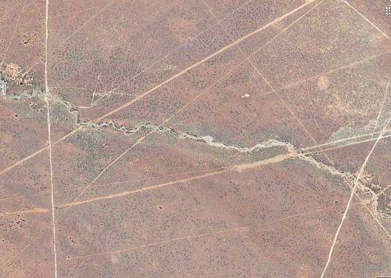
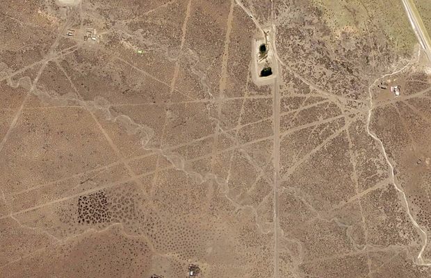
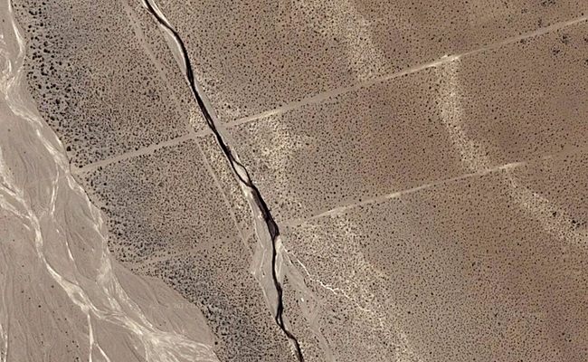
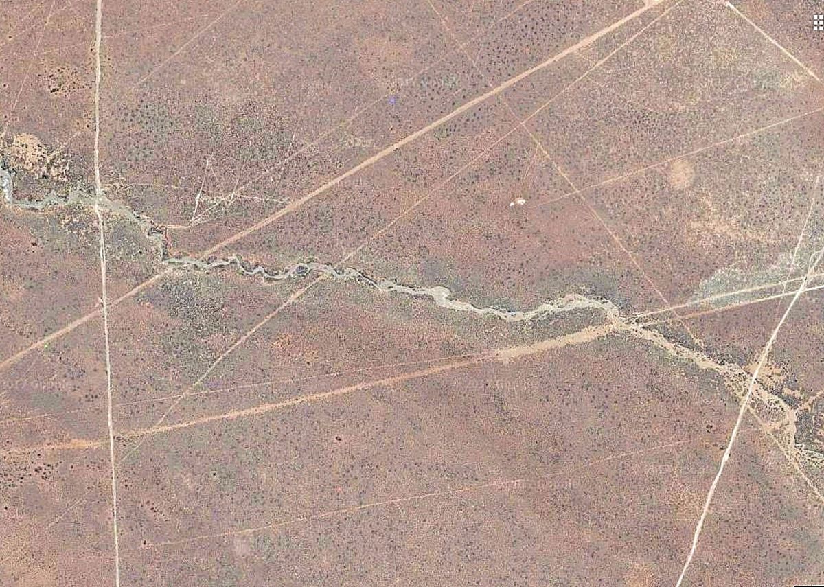
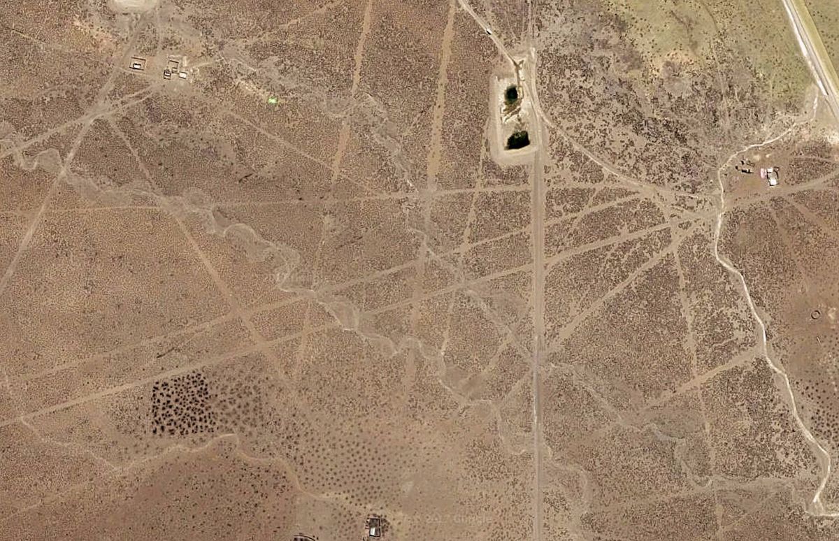
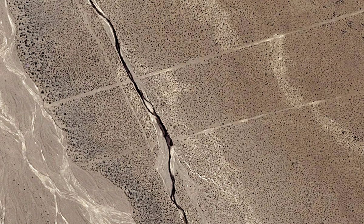
If you look at a satellite image of western Bolivia’s desolate Altiplano plateau, it will appear as if there are thousands of perfectly straight roads criss-crossing each other for no practical reason, stretching for miles and apparently leading to nowhere. Dig deeper, and you’ll discover that these are not roads at all, but white lines etched into the desert sand.

These strange geoglyphs are a network of ancient paths etched into the earth by the indigenous people of the region some 3,000 years ago. They are found near the Nevado Sajama volcano, the highest point in Bolivia. The thousands of individual lines, each three to ten feet in width, are almost perfectly straight mile after mile in spite of the rugged terrain of the highlands—quite a feat for the indigenous people who paved them without modern technology. 

Positioned end to end, the Sajama Lines would cover 10,000 miles of terrain, leading many to call the lines the world’s largest work of art. However their exact origins are unknown to this day. 

The geoglyphs were most likely created through the process of scraping away the dark oxidized rock on the surface to reveal a lighter surface beneath. The question is, why did these people take the time and effort to pave such seemingly illogical criss-crossing trails? One theory suggests that the lines were forged to serve as footpaths leading to shrines and sacred sites, but this remains unconfirmed. A team of researchers at the University of Pennsylvania is currently investigating the history of the lines, but as of now, their origins remain a mystery.

Related Tags

Cultures And Civilizations Prehistoric Geoglyphs Geographic Markers Geological Oddities Geology

Know Before You Go

Although it is possible to visit the Sajama Lines in person, perhaps the most comprehensive way to see them is to scan the satellite view of Google Maps. Only then can the true magnitude of the lines, which seem to stretch on to infinity, be witnessed.

Community Contributors

Added By

lewblank

Edited By

Martin

  • Martin

Published

October 31, 2017

Edit this listing

Make an Edit
Add Photos
Sources
  • https://en.wikipedia.org/wiki/Sajama_Lines
  • http://www.ancient-origins.net/unexplained-phenomena/unknown-origins-incredible-sajama-lines-bolivia-002330
Sajama Lines
Sajama
Bolivia
-18.278582, -68.694866

Explore the Destination Guide

Photo of Bolivia

Bolivia

South America

Places 32
Stories 12

Explore the Destination Guide

Photo of Bolivia

Bolivia

South America

Places 32
Stories 12

Related Places

  • A polished Petoskey Stone.

    Harbor Springs, Michigan

    Petoskey State Park

    A popular place to pick up prehistoric coral fossils from the time when Michigan was an ocean.

  • The Red Stone

    Leiden, Netherlands

    Leiden Stones

    A trio of red, white, and blue stones embedded in the streets of Leiden are markers of medieval territory and law.

  • Taum Sauk Mountain in the fall.

    Ironton, Missouri

    Taum Sauk Mountain

    In the St. Francois Mountains in the Ozarks at 1,772 feet above sea level, Taum Sauk Mountain is the highest (and possibly oldest) peak in Missouri.

  • Glasgow, Scotland

    Govan Stones

    Early Medieval stones sit on display at the beautiful Govan Old Church in Glasgow.

  • The Summit of Mount Washington

    Jackson, New Hampshire

    Mount Washington

    The highest point in the state of New Hampshire, and while unlikely "the worst weather in the world," it sure seems that way to hikers.

  • Las Cruces, New Mexico

    Prehistoric Trackways National Monument

    Wee (and not so wee) footprints that insects and reptiles of the Paleozoic Era left behind.

  • Leif the Lucky bridge at Midlina.

    Iceland

    Bridge Between Continents

    Walk in the footsteps of the gods and straddle two tectonic plates.

  • The musical stone

    Qobustan, Azerbaijan

    Musical Stone of Gobustan

    Resonant stone, that has been played since prehistoric times.

Aerial image of Vietnam, displaying the picturesque rice terraces, characterized by their layered, verdant fields.
Atlas Obscura Membership

Become an Atlas Obscura Member


Join our community of curious explorers.

Become a Member

Get Our Email Newsletter

Follow Us

Facebook YouTube TikTok Instagram Pinterest RSS Feed

Get the app

Download the App
Download on the Apple App Store Get it on Google Play
  • All Places
  • Latest Places
  • Most Popular
  • Places to Eat
  • Random
  • Nearby
  • Add a Place
  • Stories
  • Food & Drink
  • Itineraries
  • Lists
  • Video
  • Podcast
  • Newsletters
  • All Trips
  • Family Trip
  • Food & Drink
  • History & Culture
  • Wildlife & Nature
  • FAQ
  • Membership
  • Feedback & Ideas
  • Community Guidelines
  • Product Blog
  • Unique Gifts
  • Work With Us
  • About
  • FAQ
  • Advertise With Us
  • Advertising Guidelines
  • Privacy Policy
  • Cookie Policy
  • Terms of Use
Atlas Obscura

© 2025 Atlas Obscura. All Rights Reserved.