Trips Places Foods Stories Newsletters
Loading...
Loading...
Loading...
Loading...

No search results found for
“”

Make sure words are spelled correctly.

Try searching for a travel destination.

Places near me Random place

Popular Destinations

  • Paris
  • London
  • New York
  • Berlin
  • Rome
  • Los Angeles
Trips Places Foods Stories Newsletters
Sign In Join
Places near me Random place
All Ecuador Laguna Quilotoa

Laguna Quilotoa

A turquoise lake within a volcanic crater.

Ecuador

Added By
Tao Tao Holmes
Email
Been Here
Want to go
Added to list
CAPTION
Laguna Quilotoa   taotaoholmes / Atlas Obscura User
Laguna Quilotoa   Cecilia Heinen
Laguna Quilotoa   Gjadan
Laguna Quilotoa   amalavida.tv
Laguna Quilotoa   taotaoholmes / Atlas Obscura User
Laguna Quilotoa   Alicia0928
  breaingram / Atlas Obscura User
  barnatanko / Atlas Obscura User
  barnatanko / Atlas Obscura User
Been Here
Want to go
Added to list

About

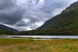
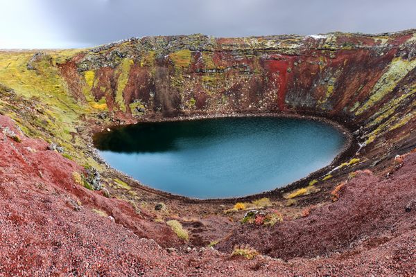
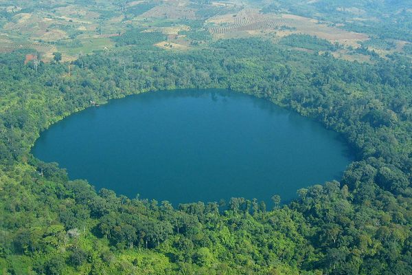
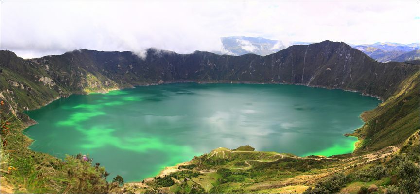
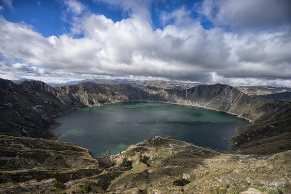
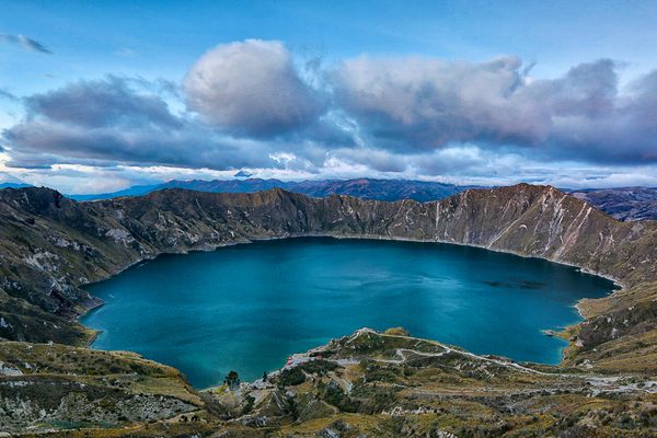
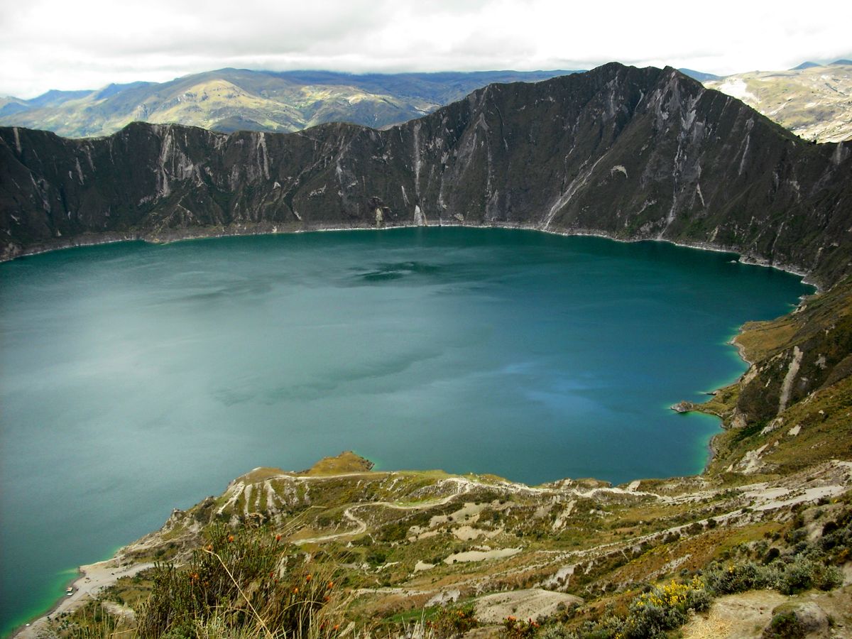
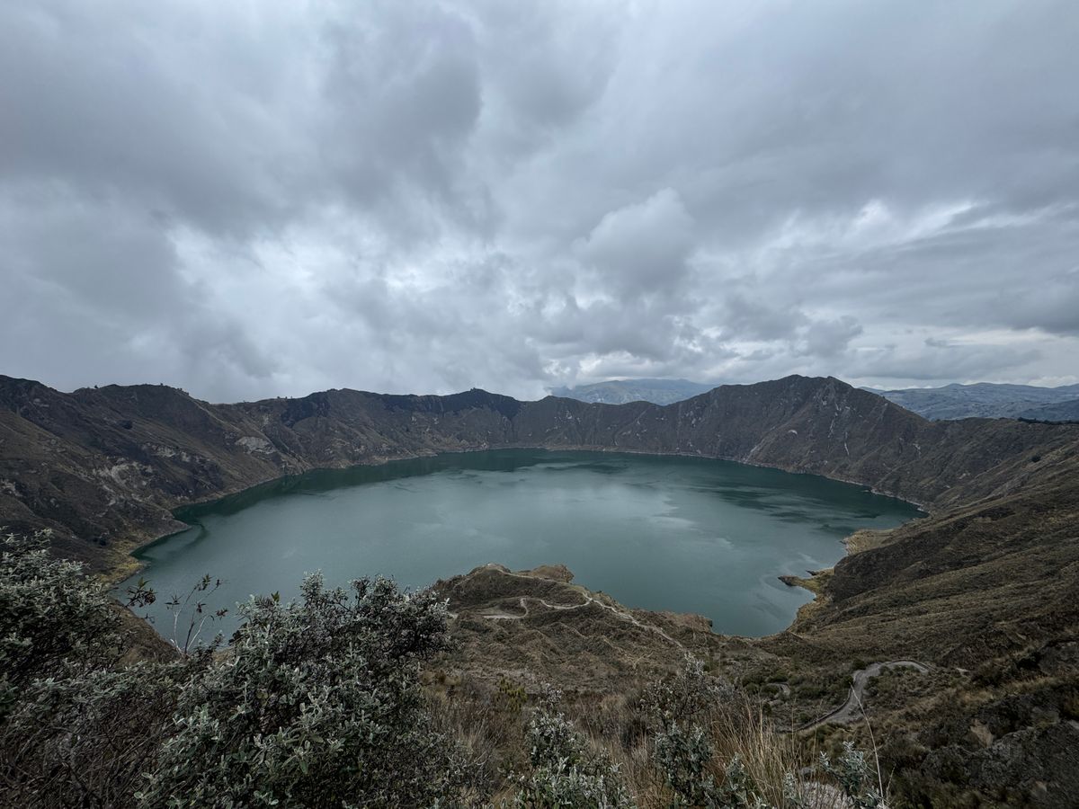
When the Quilotoa volcano last erupted in 1280, it left behind a gaping caldera 3 kilometers (1.8 miles) across, which is now filled with brilliant turquoise water. The word "quilotoa" comes from the local Quechua language, a group native to the central Andes region.

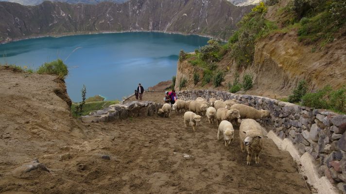
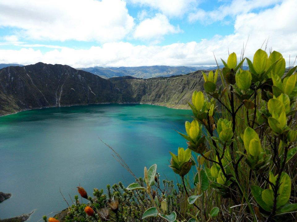
At an elevation of around 3,800 to 3,900 meters (12,467 to 12,795 feet), Ecuador's Laguna Quilotoa is tucked within a rugged countryside, criss-crossed with well-worn hiking trails crawling all over the Andes mountain. The area is still home to many indigenous peoples, who make their living farming on the land much as they have for thousands of years. You'll see their homes and patches of farmland dotting the hillsides and meet them on the trails nearby, usually wearing traditional Andean clothing and often herding sheep with a llama or two. 

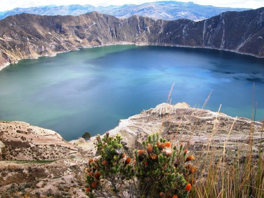
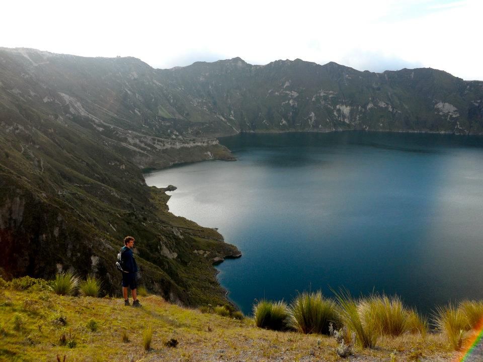
The tiny town of Quilotoa sits nearby to the lake's southwest, and is the best place to view the lake and begin the hike around its rim. The hike along the rim of the crater is about 7.5 km (4.7 miles), offering four or five hours of views down into the deep lake. 

Some of trails are suffering from erosion, especially those leading to the area at the base of the crater, where you can wander or even camp. But since the lake is only accessible by local buses and winding mountain roads, it remains less frequented than some of the region's other spots. On some days, you might hike the caldera's entire circumference and pass no one else—just a few wildflowers, and maybe a stray dog or sheep or, if you're lucky, a llama or two. 

Quilotoa Lake is the beginning or end of a self-guided multi-day trek through the surrounding Andean mountain towns, often on poorly marked trails leading you into and out of rugged, deep canyons. The hike is an adventure and a challenge for any experiences hiker, but it's not a backcountry trek: you can stay in local hostels and hotels every night as you hike, complete with a hot shower and a delicious meal for about $15 a night. Most people do the hike in 3-5 days, and follow the route from Latacunga > Sigchos > Isinlivi > Chugchilan > Quilotoa > Latacunga. The hike in this direction has a total of 2152 meters/7,060 feet of ascent and 1184 meters/3884 feet total of descent, across roughly 30 kilometers/18.6 miles.

Related Tags

Lakes Volcanoes Craters Water Natural Wonders Geology Nature

Know Before You Go

It costs $2 to enter the town of Quilotoa.If you just want to make a short visit, there are multiple buses each day from Latacunga to Quilotoa (1 hr 45 min). Take Zumbahua-Quilotoa-Chugchilan bus for $2.50. You will take this bus past a ā€œWelcome to Quilotoaā€ sign. Don’t get off here. It’s not actually Quilotoa for a couple more kilometers. Once you approach a highway exit for Quilotoa, get off. The bus will continue left towards Chugchilan, but you will walk into town. Alternatively, you can make the three-hour direct drive from Quito. There's a wonderful hotel directly across from the entrance to the Quilotoa Lake called Hostal Chukirawa. Sitting at such a high altitude, altitude sickness prevention pills are recommended. Also, the town is foggy and cold - bring a warm jacket, and make sure that your hotel will be warm (such as a fireplace in your room and warm down blankets).

Atlas Obscura Adventures

Wild Galapagos: An Ecological Wonderland

Darwin's legacy, snorkeling, volcanic landscapes & conservation insights.

Book Now

Community Contributors

Added By

taotaoholmes

Edited By

williamsburger, Blindcolour, PracticalWanderlust, aribrown...

  • williamsburger
  • Blindcolour
  • PracticalWanderlust
  • aribrown
  • marketing 3cfe2cb2
  • barnatanko
  • breaingram

Published

July 15, 2016

Edit this listing

Make an Edit
Add Photos
Sources
  • https://en.wikivoyage.org/wiki/Laguna_Quilotoa
  • http://www.alongdustyroads.com/posts/2015/6/11/ten-things-to-know-before-hiking-the-quilotoa-loop-guide
  • http://practicalwanderlust.com/2016/09/hiking-the-quilotoa-loop-ecuador.html
  • https://www.ecuadorhop.com/quilotoa/
Laguna Quilotoa
Ecuador
-0.861193, -78.897285

Nearby Places

Casa El Pacto

PĆ­llaro, Ecuador

miles away

Chimborazo

Ambato Canton, Ecuador

miles away

Swing at the End of the World

Banos, Ecuador

miles away

Explore the Destination Guide

Photo of Ecuador

Ecuador

South America

Places 40
Stories 27

Nearby Places

Casa El Pacto

PĆ­llaro, Ecuador

miles away

Chimborazo

Ambato Canton, Ecuador

miles away

Swing at the End of the World

Banos, Ecuador

miles away

Explore the Destination Guide

Photo of Ecuador

Ecuador

South America

Places 40
Stories 27

Related Places

  • Kerid Crater Lake

    Iceland

    Keriư Crater Lake

    This eye-popping Icelandic crater lake is surrounded by red volcanic rock.

  • Wizard Island

    Crater Lake, Oregon

    Crater Lake

    The deepest lake in the United States, and once the site of epic destruction that lives on in legends.

  • A view of the perfectly round Lac Pavin.

    Besse-et-Saint-Anastaise, France

    Lac Pavin

    This volcanic crater lake is renowned for its perfectly round shape, stunning blue-green waters, and unique geological properties.

  • The salt lake becomes colorful in warm temperatures because of algae growth

    Yuncheng, China

    Yuncheng Salt Lake

    Rainbow-hued in the summer and crystalline in the winter, this salty lake has inspired battles, temples, and plenty of awe.

  • Lake Posta Fibreno

    Carpello, Italy

    Lake Posta Fibreno

    This serene, turquoise lake in an extraordinary nature reserve showcases a rare natural phenomenon.

  • Kailua-Kona, Hawaii

    Keahole Point Blowhole

    This unusual lava tube spouts seawater during high surf.

  • Aerial view of Yak Loum Lake, Cambodia.

    Krong Ban Lung, Cambodia

    Yeak Laom

    Arguing within this idyllic, circular volcanic lake is forbidden.

  • Painted Dunes from the top of the adjacent cinder cone.

    Old Station, California

    Painted Dunes

    Sunset-colored dunes of volcanic ash make taking a poor photo impossible.

Aerial image of Vietnam, displaying the picturesque rice terraces, characterized by their layered, verdant fields.
Atlas Obscura Membership

Become an Atlas Obscura Member


Join our community of curious explorers.

Become a Member

Get Our Email Newsletter

Follow Us

Facebook YouTube TikTok Instagram Pinterest RSS Feed

Get the app

Download the App
Download on the Apple App Store Get it on Google Play
  • All Places
  • Latest Places
  • Most Popular
  • Places to Eat
  • Random
  • Nearby
  • Add a Place
  • Stories
  • Food & Drink
  • Itineraries
  • Lists
  • Video
  • Podcast
  • Newsletters
  • All Trips
  • Family Trip
  • Food & Drink
  • History & Culture
  • Wildlife & Nature
  • FAQ
  • Membership
  • Feedback & Ideas
  • Community Guidelines
  • Product Blog
  • Unique Gifts
  • Work With Us
  • About
  • FAQ
  • Advertise With Us
  • Advertising Guidelines
  • Privacy Policy
  • Cookie Policy
  • Terms of Use
Atlas Obscura

© 2025 Atlas Obscura. All Rights Reserved.