The Ancient Mesoamerican City That Spawned Copies of Itself
New laser imaging shows Izapa’s suburbs were like mini-capitals.

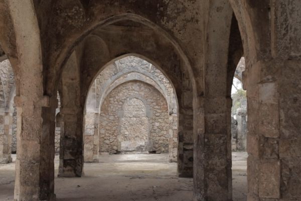
The ancient Izapa kingdom, located in the southern part of present-day Mexico, sprawled out over 170 square miles, so rural villagers seeking a taste of city life in the capital had quite a haul ahead of them. But it turns out that those on the outskirts had a feel for the city right at home. New research reveals that the kingdom—which peaked from 700 B.C. to 100 B.C., sometime between the Olmec and the Maya—consisted of more than its capital city, also known as Izapa. It boasted some 40 satellite settlements, each of which was deliberately modeled in the capital’s image.
The research, published in the journal Antiquity, demonstrates for the first time that there was more to the kingdom than its central city. Though the study calls Izapa “the largest and best-known pre-Hispanic city in the lowland Pacific region of southern Mesoamerica,” its suburban regions had gone all but ignored, save for some incomplete, if accurate, maps. “No kingdom, no state, no polity,” with very few exceptions, “is just a capital city,” says Robert M. Rosenswig, an archaeologist at the State University of New York at Albany and coauthor of the study. “I knew there were going to be other centers around.”
To find those centers, the researchers used lidar technology, which uses lasers beamed down from and bounced back to a small plane to see through thick vegetation to the landforms and structures beneath. Because lidar can be used through even the most hazardous and impenetrable jungle terrain, Rosenswig says, the technology is “exploding” among archaeologists, in Mesoamerica and beyond. Now they are collecting reams of data without setting foot on a site.


But that data on its own doesn’t precisely explain what a mound under the jungle canopy actually is. Rosenswig says the team spent months visiting each and every mound their lidar had documented, and dated ceramic sherds found at sites to determine whether the settlements were occupied at the same time as the capital. What they found were about 40 sites, and saw that each was laid out just like the city of Izapa. Together, they form what the researchers call the “Izapa pattern.”
According to the pattern, each settlement featured a pyramid at its northern end—likely the site of rituals and ceremonies—and a plaza to the south. This means that all across the kingdom people would have seen the same thing when facing north: the Tacaná and Tajumulco volcanoes framing the local pyramid. These findings reveal more than Izapa’s scale, but also demonstrate a cultural unity that persisted across wide distances. The volcanic view “indicates kingdom-wide rituals physically structured by the built environment,” the researchers write, that “reinforced the political and social hierarchy through cosmological association.”
Izapa isn’t the only ancient kingdom to replicate itself throughout its domain. El Ujuxte, in Guatemala, demonstrates similar internal consistency—but with distinct patterns all its own. Rosenswig draws a parallel between these Mesoamerican societies and Christian Europe, where Catholic sites resemble each other in layout (but differ from Protestant sites, for example). So the Izapa pattern may not be an anomaly, but Rosenswig wasn’t expecting it, either. It’s just that hardly anyone had looked.


Follow us on Twitter to get the latest on the world's hidden wonders.
Like us on Facebook to get the latest on the world's hidden wonders.
Follow us on Twitter Like us on Facebook