Ghostly Satellite Image Captures the Arctic ‘Losing Its Soul’
In the aftermath of an extreme melt event, what do scientists see in the Greenland Ice Sheet’s swirls of white, blue, and ominous gray?
“We started hearing a noise, like breaking, or coins falling,” says Marco Tedesco, a climate scientist at Columbia University’s Lamont-Doherty Earth Observatory. He makes a loud, sustained crunching sound, recreating what he and his team heard, years earlier, while doing fieldwork on the Greenland Ice Sheet. Below the surface of the ice near where they were standing, a flood had begun. “The water below starts to move but you still have snow on top,” Tedesco says of the phenomenon. As the flowing water gains momentum, overlying snow and ice give way and reveal a meltwater stream or river.
What Tedesco describes is a small-scale seasonal melt event, one of many that occur every summer at the lower-elevation edges of the Greenland Ice Sheet, an expanse of more than 650,000 square miles that’s second only to the Antarctic Ice Sheet in size. This year, however, things were different.
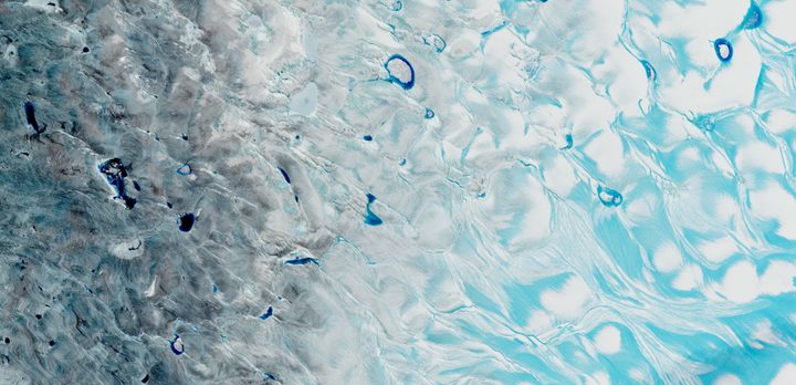
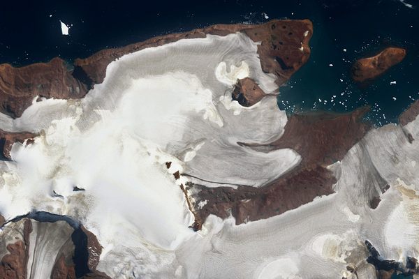
Following a mid-August heatwave that led to the first-ever recorded rainfall at Summit Camp, at the ice sheet’s highest point, torrents of meltwater streamed across its surface. Climatologists recorded daily melt rates seven times higher than normal. In the satellite image above of the southwestern corner of the ice sheet, captured on August 21, pale blue water carves extensive channels around islands of bright white ice, or collects in slushy depressions. The left side of the image is darker and, like storm clouds on the horizon, it’s a warning of what’s to come. The Greenland Ice Sheet, like the rest of the Arctic, is trapped in a feedback loop caused by climate change: As more ice melts, it creates conditions for even faster, more extreme melt events.
“The Arctic is losing its soul,” says Mark Serreze, director of the National Snow and Ice Data Center. “The Arctic in so many ways is defined by its snow and ice, in all its forms.” He adds that, while meltwater runoff at lower elevations is a natural process that has been happening each summer for millennia, “what the image really conveys is how that process of summer melt is getting bigger and bigger and bigger.”
University of Lincoln climate scientist Edward Hanna says the “quite dramatic” surface meltwater shown in the image is a scene that’s likely to be repeated because “Greenland is breaching a crucial tipping point driven by human-induced climate change.”
For Serreze, who has been studying the Arctic since 1982, the dramatic events in Greenland aren’t a surprise. “We have long known the Arctic would be the place raising the red flags first, and that’s exactly what has happened,” he says. But it’s still a shock. “To see a rain event at the top of the Greenland Ice Sheet?” He shakes his head in disbelief.

Tedesco, author of The Hidden Life of Ice: Dispatches from a Disappearing World, sees something else in both the Summit Camp rain event and the stunning satellite image taken the following week: opportunity.
“To me, it’s really important that we had an unprecedented rain event, to show that these things can happen,” says Tedesco. The Summit Camp rain may help bring wider recognition of something he and his colleagues have known for years. “These events are strongly connected to the changes we’re imposing on the planet,” says Tedesco, calling Earth “a thermodynamic system so delicate, but powerful.”
Thanks to the satellite image’s “fantastic” quality, Tedesco says, “you can really see the story that’s going on here,” including extensive meltwater ponding on the right side that’s “very likely slush.”

The left side of the satellite image, Tedesco says, sits close to Greenland’s western coast, and is colored by rock, dust, and other particles deposited by wind, as well as bacteria and other microorganisms. Its darker color accelerates melting because of a phenomenon known as ice-albedo feedback.
“Albedo is a fancy word for how reflective the surface is,” says Serreze. As highly reflective snow and ice melt, the darker surface exposed—rock, open water, or older ice, depending on the location—absorbs more of the sun’s energy and spurs even more intense melting. “We’re seeing this across the Arctic as we’re losing the sea ice cover and we’re losing the snow cover,” he says.

There’s an unexpected wrinkle revealed in the darker portion of the satellite image, however. Tedesco has studied this particular part of the ice sheet; because of the underlying topography and other factors, he and many colleagues believe that at least some of the material staining the ice was originally deposited elsewhere on the sheet, long ago.
“People think this stuff could have been buried in the ice in other places and, with the flow of the ice and increased melting, it’s now exposed,” he says, noting the idea remains largely unstudied. For him, the possibility of ancient material returning to the surface is poignant.
“This image is basically a time machine,” he says, studying the swirls and ripples of white, blue, and gray on his computer monitor with a pensive expression. “You have, on the right, the future: a patchy, wet, slushy ice sheet. You have in the middle the present, which is basically your ice now, frozen. And you have a very deep past on the left, which is also driving the future because, of course, the darker it is, the more it absorbs sunlight and the faster it melts.”


Follow us on Twitter to get the latest on the world's hidden wonders.
Like us on Facebook to get the latest on the world's hidden wonders.
Follow us on Twitter Like us on Facebook