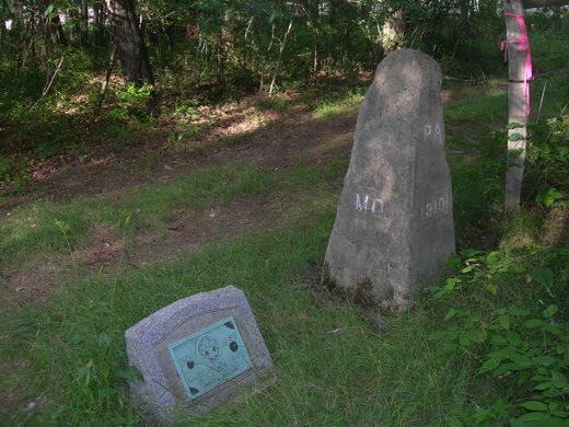
Old Tri-State Monument
This original Mason-Dixon line cairn placed in the 1760s was put in the wrong location because of the gravitational pull of the Allegheny Mountains.

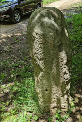

This monument was placed by astronomer Charles Mason and surveyor Jeremiah Dixon sometime between 1763 and 1767 as part of their attempt to end the Penn-Calvert Boundary Dispute by establishing the Mason-Dixon line. The long-standing dispute hinged on land grants between King Charles II and William Penn, and how they conflicted with land grants agreed between his father, King Charles I, and Lord Baltimore.
When the line was completed, over 200 stone markers were placed at one-mile intervals to indicate the border. This is not one of those markers, it is older. As the Mason-Dixon team actively moved across the land, they would build much cruder monuments that were ultimately replaced by newer, more standardized markers.
This crude cairn has Pennsylvania, Virginia, and Maryland marked on what was thought to be their respective sides of the border. When the Mason-Dixon data was analyzed by the Royal Society, it was determined that the gravitational pull of the Allegheny Mountains had disrupted the surveying equipment. Once the disruption had been adjusted for, the Tri-State border was found to be about 1,000 feet to the east, where it is marked today by a different monument placed by the Boy Scouts of America in 1910.
It is not known how many of these original cairns were erected by the Mason-Dixon party, but there are only a handful left known to records as the landscape has changed with property transactions and developments.

Plan Your Trip
The Atlas Obscura Podcast is Back!


Follow us on Twitter to get the latest on the world's hidden wonders.
Like us on Facebook to get the latest on the world's hidden wonders.
Follow us on Twitter Like us on Facebook