Notes From the Field: Exploring the Remains of a Forgotten Los Angeles Disaster
Concrete rubble scattered along a washed-out road is all that remains of St. Francis Dam, the Los Angeles disaster that no one talks about. Fascinated with the disaster shrouded in secrecy that wiped out entire towns, a power station, and washed hundreds of dead into the Pacific, I had to see what was left. Skeptical of longtime locals who said there wasn’t much to look at but some old rocks, I was pretty sure they just weren’t looking very closely. So I put on my “Atlas Eyes” and headed for the canyon.
Marcelo and Honey Bear survey the valley where several souls, including the dam keeper and his wife, were lost (all photographs by the author)
On March 12, 1928 the St. Francis Dam burst, sending a wall of water up to 78 feet high at times through the Santa Clara Valley. Gigantic chunks of concrete, twisted metal, and everything the monstrous wave came into contact with was launched downhill as 12 billion gallons of water raced 54 miles toward the Pacific Ocean. Entire towns washed away, and as many as 600 residents perished in what remains the second largest loss of life in California history, overshadowed in tragedy only by the 1906 San Francisco Earthquake.
The most catastrophic American engineering accident of the 20th century was also deeply embroiled in the California Water Wars — a brutal conflict that began when the newly developed Los Angeles Department of Water and Power began diverting water from Owens Valley via an aqueduct into the swiftly growing metropolis of Los Angeles. The project, headed by self-taught engineer William Mulholland, infuriated the Owens Valley agricultural community, and in their refusal to back down the clash quickly escalated to sabotage, legal battles, and at its peak a section of the system was destroyed with dynamite after armed farmers took it by force.
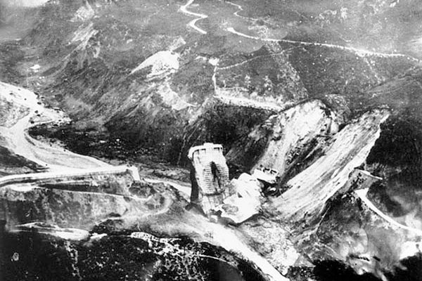
St. Francis Dam in 1928, clearly filled to capacity (via documentingreality.com)
The day the dam gave way, Mulholland himself had been to the site inspecting a small, but persistent, leak on the west abutment. A few others had appeared in this same location in the past, and the dam keeper had called Mulholland to come down and take a look. After deeming the leak in need of attention but not an immediate danger, Mulholland went back to Los Angeles. A few minutes before midnight that very night, he was proven horribly wrong.
At first assumed to be another attack by the residents of Owens Valley, it was later determined that the cause of the failure was due to the geological properties of the landscape. The west abutment was anchored to a reddish conglomerate that softened considerably when wet, and the eastern side of the canyon was composed of a harder, but equally unstable, shale. Although a horrified Mulholland publicly accepted responsibility, the courts found that although he had been in error, he had no way to know that the canyon’s geology was so unstable, and he was cleared of any criminal negligence.
Easy to find if you know where to look, the remains of the dam quietly rest off of San Francisquito Canyon Road, a short, simple hike down the former road that was rerouted in 2005 after suffering heavy storm damage. Having recently read a book on the disaster and intrigued that so few people I spoke with had ever heard of it, I asked a friend who was an avid hiker if she knew the area and could take me there. We headed into the San Francisquito Canyon to see the origins of William Mulholland’s downfall and the disaster that Los Angeles prefers swept under the rug.
Abandoned road leading to the ruins
The road leading to the ruins of the dam was destroyed beyond reasonable repair during a storm in 2005, and rerouted farther away from the remains of the dam. Slowly overtaken by nature, it’s a fitting path to the fallen structure.
We didn’t encounter anyone on our hike, but clearly this was a popular spot for the average shenanigans that take place in spooky, remote spots.
The eastern wall of the canyon with rubble at its feet
At the site where the dam formerly stood, a closer look reveals rusted cables jutting out of concrete chunks
This is some of the only semblance of structure remaining at the site itself.
When the dam burst, the only part of the structure that still stood was a jutting piece in the center of where the it used to be that was nicknamed “The Tombstone.” A few months after the collapse, a teenager fell to his death from the Tombstone after his friend tossed a rattlesnake at him as a prank. Shortly after, the last standing section of the dam was taken down by dynamite. This is what’s left of the Tombstone now.
Surveying the canyon from the Tombstone remains, no rattlers in sight
After exploring the main site, we continued down the road to see the sections of the dam that had been washed further into the canyon.
The most recognizable chunk of construction was this piece, located almost a mile away from the disaster site.
One lonely pile of rubble at least 1/2 a mile from where it began
Here is a gigantic chunk of the dam that was most likely the 10,000 ton piece that reportedly washed down the canyon. It was located almost a mile from the site.
This is the view from the top of the 10,000 ton section, looking up the valley toward the original dam location, just beyond the first mountain. While unfathomable, this angle gives the best perspective of how far the water carried the gargantuan chunks of concrete and metal.
On our way back down the canyon, we stopped at Powerhouse #2, a location that was completely wiped out by the flood and has since been rebuilt. This plaque behind their chain link fence was the only acknowledgment of the disaster in the area.
More photos from the remains of the dam:
To visit the ruins of the St. Francis Dam yourself, drive north on San Francisquito Canyon Road to Power Station #2, and continue about 1.3 miles until you’ve crossed a small bridge. Park on the left and locate the Forest Service gate. The gate is visible from the road, and the trail and a large chunk of dam can be seen from the gate.
One of the most important things to us here at the Atlas is to always keep traveling and discovering. Notes from the Field are first person reports from the most inspiring trips taken by the Atlas Obscura Team. Read more Notes From the Field here>


Follow us on Twitter to get the latest on the world's hidden wonders.
Like us on Facebook to get the latest on the world's hidden wonders.
Follow us on Twitter Like us on Facebook