The Return of Glen Canyon
As Lake Powell’s water levels continue to drop, a stunning landscape resurfaces—along with questions about the future of the Colorado River and those who depend on it.
This piece was originally published in High Country News and appears here as part of our Climate Desk collaboration.
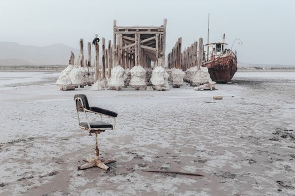
There is the crumpling, the mess. A marina that once floated in a cove has been towed out of the shrinking lake and dropped in a field of Russian thistle, its metal pontoons partially sunk into dry, crack-crazed soil. Cooler doors stand open—the marina was once known for its ice cream—and conduits hang from ceilings, wires stripped.
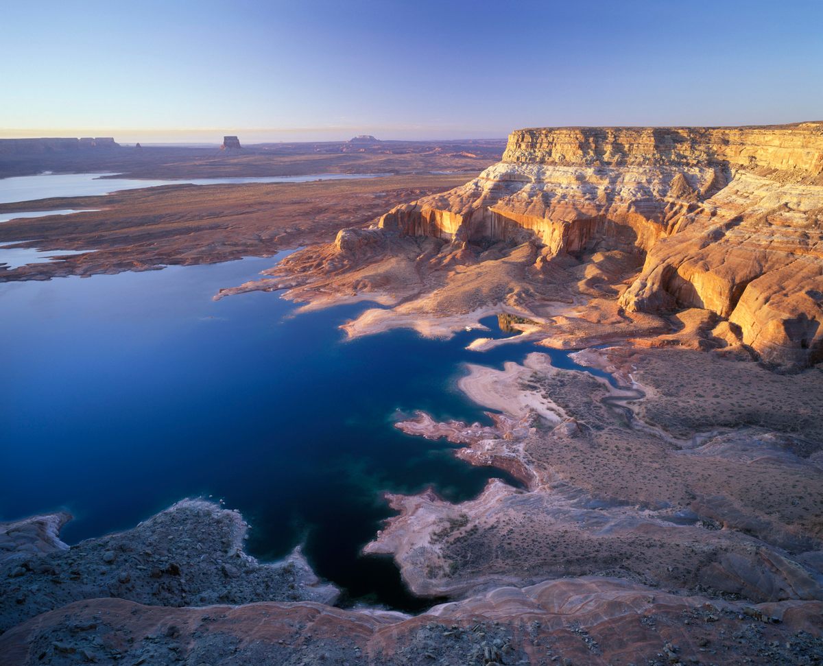
Any restoration might look like this at the start, might exude the strange ugliness of decay. Dangling Rope Marina, the size of a couple of convenience stores, once sold 1.5 million gallons of gas every year, powering the hundreds of boats that, on any given summer day, plied the watery pleasure garden of Lake Powell. Now, its outer doors hang half-open; the interpretive displays bleach in the sun. The official reason for its 2021 closure was “significant wind damage and low water conditions.” The cove it once occupied is disappearing, turning back into land as the lake levels fall. The depth of the surrounding bay has dropped from about 200 feet to 35 feet, and only one of the boat ramps is still operable.
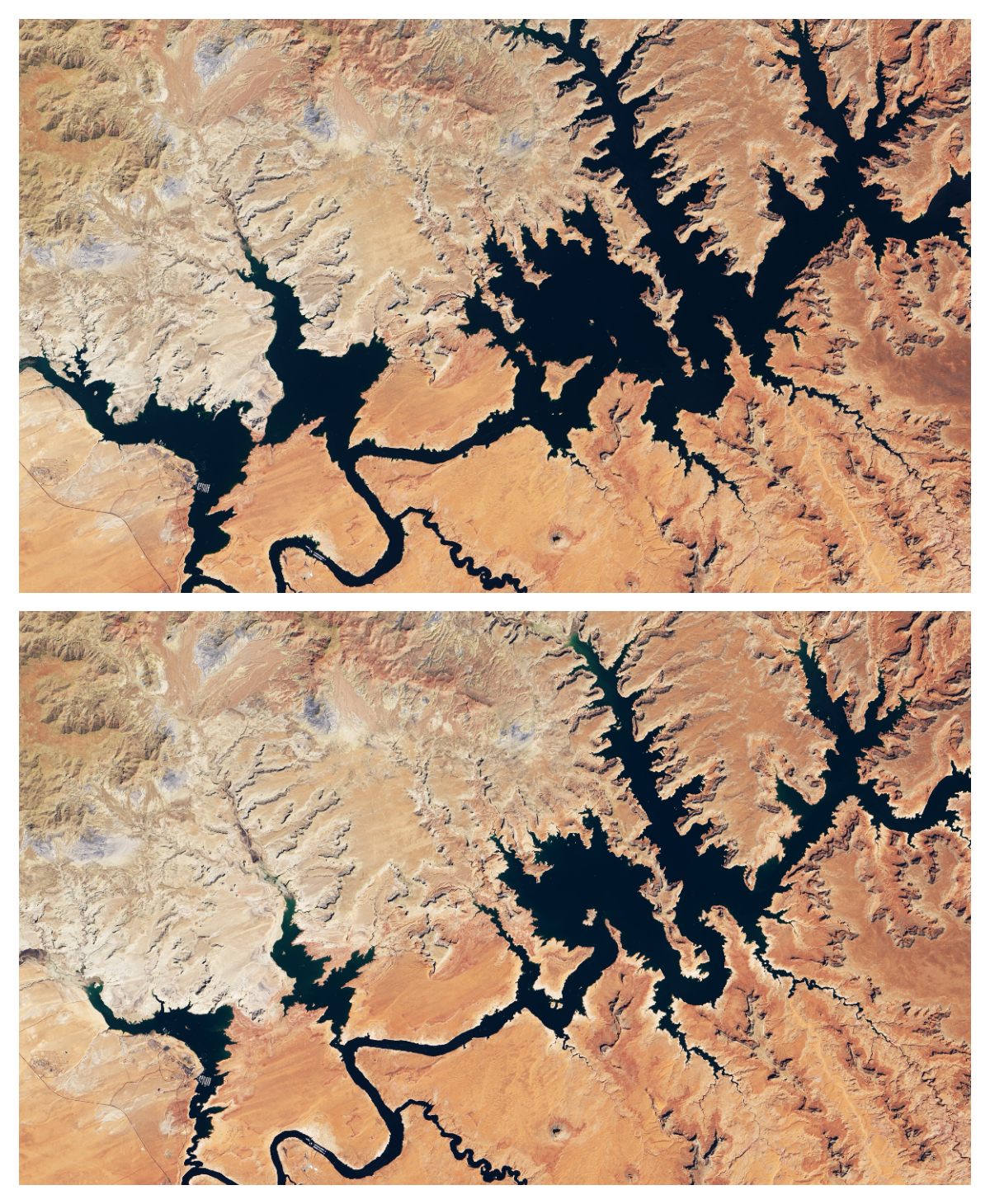
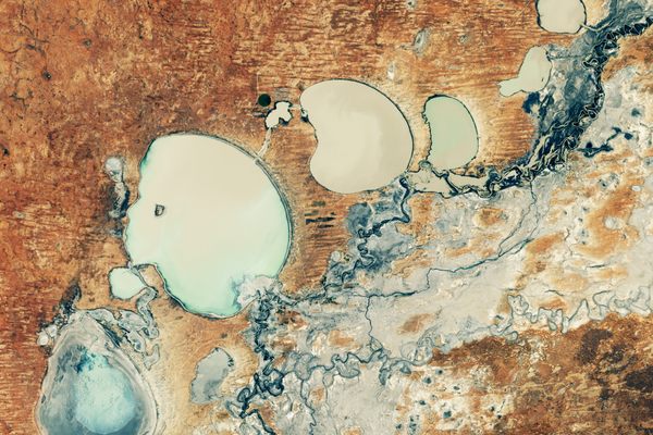
Lake Powell, like its downstream neighbor Lake Mead, stands at a quarter of its full capacity. An increasingly arid climate, high demand from thirsty agriculture, and the bad math embedded in the century-old compact that divides the Colorado River’s water have shrunk the two reservoirs to levels not seen since they were first filling. On Lake Powell’s new shoreline, old boat propellers lie in the dust along with scads of sunglasses. Red plastic drinking cups, some bearing names scrawled in Sharpie, have yellowed to the color of piano ivory.
At its low point last year, Lake Powell’s surface was only 32 feet above operating levels for Glen Canyon Dam’s hydropower intakes, reducing the dam’s power output by half. If reservoir levels fall as dramatically this year as they did last year, the hydropower system—which supplies seven states—will fail. If the reservoir can no longer release adequate amounts of water from the upper reaches of the Colorado, downstream water rights could be rendered meaningless.
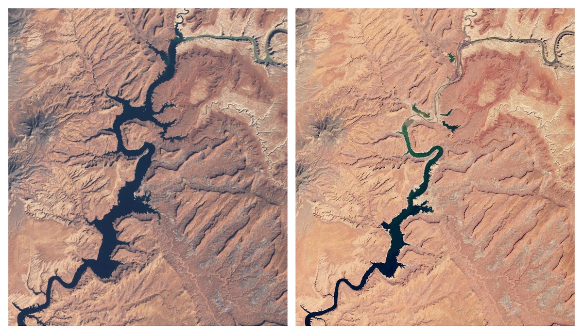
Lake Powell, the second-largest reservoir in North America after Lake Mead, is on its way out. Water levels in the canyon system have fallen more or less steadily for two decades, and refilling it to full capacity, or even half capacity, appears to be off the table. The current policy of the U.S. Bureau of Reclamation, which manages both Powell and Mead, is to prop up Powell by taking water from smaller reservoirs upstream, reducing releases into the Grand Canyon and Mead, cutting back water use throughout the Colorado River Basin, and praying for a good snowpack. All this may succeed in maintaining Lake Powell at its current diminished level—if only for the time being.
Faced with rubbish, disarray, and onrushing disaster, it would be easy to stop here, to throw in the towel—yet another artifact frequently found on Powell’s former beaches—and head home. Let’s keep going, though; as this story ends, another is emerging.
I first visited Lake Powell in the 1970s, when I was in grade school and the new reservoir was still filling up. My dad and his friends rented a houseboat, and as they motored up the lake’s San Juan Arm—the drowned final stretch of the San Juan River—I sat on the bow with my bare feet dangling, my toes splitting the dreamlike panorama of reflected cliffs.
I remember a landscape composed of three bold swaths, like a tricolor flag: the bright blue of the sky, the hard, voluptuous curves of the earth, and the unfathomable blue of the water. I had no idea why there was so much water here; I knew nothing of the dam downstream. When we anchored, I ran barefoot across naked sandstone, unaware that the rising waters would soon cover it. I was a Sonoran Desert boy from the Phoenix area, where my landmarks were tall cactus and snaggletooth mountains. Lake Powell showed me a sandstone desert shaped like soft-serve ice cream—the sensuous heart of the Colorado Plateau.
One evening, as we made camp, thunderstorms roamed the desert, booming in the distance. Suddenly, the entire northern sky turned molten red. Sunset had already passed; the adults talked among themselves, wondering what had caused the sky to glow. A forest fire, perhaps? But there was no forest nearby to burn. Finally, they decided it had to be the northern lights, visible from unusually far south. The night bristled with a sense of mystery, smelling of far-off rain and buzzing with the grownups’ concern. Surrounded by water, bare stone, and a sky on fire, I felt as if I’d landed on an alien planet.
Not until my 20s, when I began working as a river guide, did I learn about the reservoir’s ruinous backstory. The Colorado River Compact, signed in 1922, divvied up the river’s water between seven states, made only a glancing acknowledgment of tribal water rights, and left no water at all for the river itself. (The compact also seriously overestimated the river’s average flow, meaning that the river is usually left with less than nothing.)

The agreement, which made it clear that the water was to be used for development above all else, laid the legal foundation for federal dam construction on the river. First came Hoover Dam, behind which Lake Mead began to rise in 1935; about three decades later, when Glen Canyon Dam was close to completion, Lake Powell started to inundate the sandstone labyrinth of Glen Canyon, the hydrologic and ecological core of the Colorado River system. Over the years that followed, 186 miles of river were swallowed by a lake.
The late Katie Lee would have kicked me in the shins for calling Powell a lake. One night, at her dinner table in Jerome, Arizona, I told the fiery activist—in her 80s at the time—that I thought Lake Powell was beautiful. By the time I was born, it had already been filling for four years, and I had never known Glen Canyon. Katie brought out a dictionary and read the definition of “lake” to me. Powell, she said, is a reservoir, not a lake; it’s man-made, not natural. It’s a goddamned monstrosity.
Earlier that day, she laid USGS maps from before the dam across her living room floor, matching up their edges so the river appeared to flow. The river was blue and thin and wound like a snake through dense brown contour lines. She traced its course with her finger and told me about sandbars in the sun and secluded grottos. She began to cry.
At the dinner table, sitting with her partner, Joey, she said that if I thought the reservoir was beautiful, we couldn’t be friends. We managed to be friends anyway. Over the years, I invited her to visit the reservoir with me, to float on this paradoxical body of water and look down into its depths. I wanted her to point out the places where she had once rowed and scrambled, built driftwood fires, stood naked against warm sandstone. She told me to stop asking.
For more than half a century, Katie Lee railed against what she called Lake Foul, calling for the dam to come down so that the river could flow again. By the time she passed away at 98, in 2017, she had inspired generations of activists to keep the memory of Glen Canyon alive.
Under blue skies last October, I joined three others in a wooden dory fitted with a 4-horsepower electric motor. We put in at the last functioning boat ramp at Bullfrog Marina, not far from the dilapidated remains of Dangling Rope, and headed south, downstream.
The dory, named Stella, is a sleek craft made for lakes and ocean travel, constructed in Flagstaff, Arizona, by master dory-builder Brad Dimock. My wife sat up front, holding the coiled bowline, and the dory’s owner, a mutual friend, ran the tiller in the stern. I sat in the middle on a heap of dry bags, ready to take the oars if we needed to maneuver through narrow side canyons. We moved south at 4 mph, about the speed of the Colorado before the dam impounded it, accompanied by the quiet buzz of the boat’s solar-powered motor. The bread-loaf cliffs of Navajo sandstone passed slowly enough for the buttes and arches to casually turn their faces, nothing hurried in their demeanor.

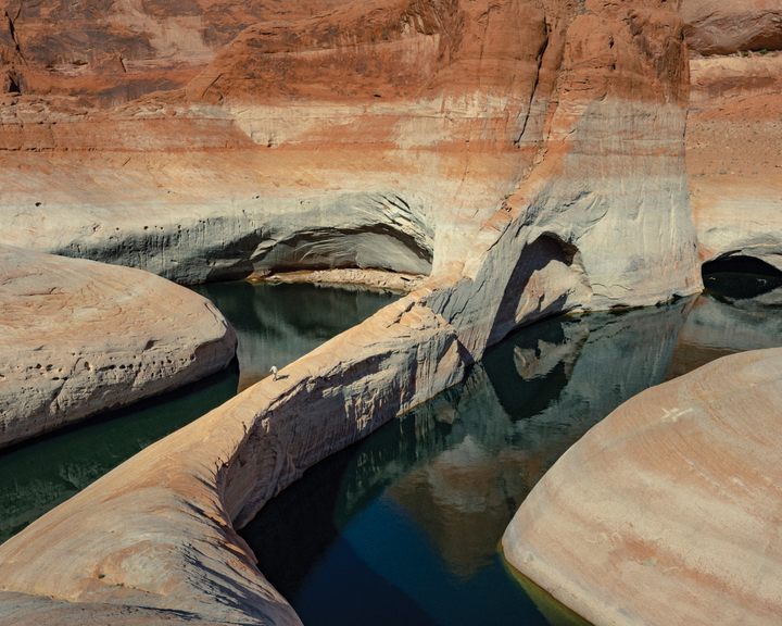
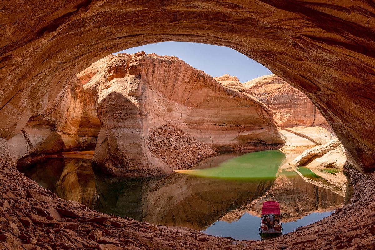
We passed over the ghostly forms of rock steeples and buttes, green ogres rising from the depths. Within a year or two, they will likely touch the surface, and then keep rising. We drew Stella into the shade of an alcove and cut the motor, drifting into a natural stadium inundated nearly to its ceiling. When Katie Lee floated here 70 years ago, this yawning mouth in the canyon’s architecture sat 200 feet above the river. She would have looked up and marveled at the underside of this cupola, a dome the size of a baseball field set high against the sky, out of reach.
Two years ago, this entire feature was underwater, invisible. Now, thanks to the recent, rapid drawdowns, the rock dome hung 20 feet above us, sparking with reflected light. Gentle waves gulped and echoed against the stadium’s back wall.
In a decade or two, the dome may soar again. The green ogres we see below the surface may rise again and tower over our heads like gigantic statues. In the face of a water infrastructure calamity, what may become the largest restoration project on Earth is progressing with little assistance from us.
Could I convince Katie Lee to come with me now, knowing what we would see? The lake is now as low as it was in 1967, four years after the reservoir began to fill. But I don’t think she would be impressed; to her, even the shrinking reservoir would look like a corpse. Remembering the beauty buried below, she might vomit over the side of the boat, cursing me for bringing her here.
Every river that feeds the Colorado is a mud bath, and in the spring and after storms these tributaries turn a dense red, brown, or green. The Colorado itself carries tons of sand, silt, mud, rocks, and gravel, evidence of the geologic breakdown of the Rocky Mountains and everything around them. Since the 1960s, all of that sediment has been accumulating at the bottom of Lake Powell—especially at its northern end, where the river’s current slows, stills, and drops all that it carries, leaving the lake crystal-clear.
“If you can’t see it, it’s really easy to ignore,” said Cari Johnson, a field researcher and sedimentology professor at University of Utah. Johnson studies the deposit of mud, silt, and sand that she and many other geologists informally call the “Dominy Formation” after Floyd Dominy, who led the construction of the Glen Canyon Dam as the head of the Bureau of Reclamation in the 1950s and ’60s, and who argued vigorously that silt would not be an issue at Lake Powell for thousands of years. This particular formation, Johnson said, is “anthropogenic sedimentation,” and it can be a hundred feet thick or more. “Its origin is fundamentally tied to human interactions,” Johnson said. “This reservoir sediment would not exist if there wasn’t a dam.”
The Dominy is a new geologic layer, with its own canyons and hard-packed plains, and it’s a mess. When it emerges from the reservoir, said Johnson, its fissures belch up biogenic methane from the rotting cottonwood, willow and oak groves that once flourished in Glen Canyon. She described tons of water caught up in sediment and blocks of slumped material, crooked and collapsing around dark cracks. “I get nervous walking around on it,” she said. “Some of these fractures are deep. They are ready to fail.”
Johnson looks at Lake Powell as a vast sedimentology experiment coming to its conclusion. As its water drains, she and her colleagues can see what’s left behind. “I understand why management agencies, river runners and everyone else is focused on water,” she said. “Sediment is the underappreciated part of the system.”
In Stella, our dory, we pulled to shore in a side canyon where the Dominy Formation has been above water for a couple of years, its hardened clay surrounding boulders the size of houses. I climbed through sandstone hulks decorated with thousands of desiccated quagga mussel shells, finally reaching the top of the white bathtub ring that commemorates Lake Powell at its fullest. The ring, which consists of evaporated minerals, clings to the native rockface like a smear of powdery cement, draped like a banner across every cliff. When I was a kid, the water had nowhere to go but up. Now the ring is a hallmark of the reservoir, a baseline we may never return to. I used it to mentally refill the full pool, imagining water covering the boulders, benches and pinnacles below me.
Looking down on the canyon where we’d moored, I saw a clear stream flowing along its bottom, slicing through the Dominy Formation and pushing out the mess, flood by flood. Geomorphologists have been surprised by the speed at which the hard muck departs. I asked Johnson what she thought of the speed, and she said, “Drastic. It’s changing so fast.” Recently, she and her colleagues went to Dark Canyon, a tributary of Glen Canyon, to document depositional patterns in its reservoir sediment, which was more than 25 feet thick in places. When they arrived, they found that the entire layer had been scoured out by a flash flood. In days or weeks, tons of sediment can be carried off to the lower reaches of the reservoir, mud compounding mud. The problem simply relocates—and accumulates.

It’s easy to become disoriented in the canyons of Lake Powell, gas motor stinking and roaring, boat slaloming into hallways made for giants. Right turn, left turn, left turn, right. I’d jumped into a skiff with a 40-horsepower motor, which was three times faster than Stella’s but whose noise made it harder to talk and harder to listen. The cliffs, in shadow at the end of the day, now moved by too quickly, like a record playing at the wrong speed.
Eric Balken, the 36-year-old head of the Glen Canyon Institute in Salt Lake City, steered us into a dimming enclosure of Navajo sandstone, throttling down as walls closed in. He knew of a place where Stella could catch up to us and our group could camp, but the shorelines were changing so fast he couldn’t promise it still existed.
Balken, whose nonprofit advocates for Glen Canyon’s restoration, feels differently about this reservoir than I do. He doesn’t like it one bit. He first glimpsed the place during a high-school road trip to southern Utah with a group of friends. “We hung out on the shores of one of the big beaches near Wahweap,” he remembered. “I think my reaction was that it was odd to see so much water in the middle of the desert. I didn’t know the story of the dam, and it wasn’t till after that trip that I began to learn about the story of Glen Canyon and the tragedy of what was lost.” When he was 19, he started working for the institute, and he’s been there ever since.
Lake Powell, Balken said, is hot right now. Members of Congress, water authorities, scientists, and journalists want to see what’s happening here, and Balken has accompanied many of them into the canyons. If you didn’t know the reservoir well, you might not notice anything out of place, but if you’ve been here as many times as Balken has, it’s obvious that it’s changed.

Parts of the upper canyons that were documented by photographers in the 1950s and ’60s—long believed to be lost for good—are now fully exposed. A famed landmark, Cathedral in the Desert, has been transformed. Last year, boats visiting it pulled into the smooth round vault of a canyon bottom, tying off next to a clear waterfall that descended through a great hourglass in the rock. This year, visitors must tie up their boats downstream, then walk for 15 minutes up a creek already brimming with waist-high cottonwoods and willows. The cathedral itself smells like a herbarium, pungent with vegetation. Springs that were known only from old photographs are dripping and bubbling again, sprouting delicate fronds of maidenhair ferns.
In a year, the walk to Cathedral in the Desert may take 20 minutes; in five years, an hour. When there was no reservoir, visiting the cathedral meant walking six miles up one tributary and then another, a journey shaded by cottonwoods and cooled by trickling streams.
As our metal skiff scooted up the still-flooded side canyon, photographer Elliot Ross, a few years younger than Balken, straddled the fuel tank. Ross looked down the barrel of his lens as we peeled through a reflection of cliff walls shaded to the color of a bruised peach. For the last year and a half, he’d been exploring Lake Powell and its fans of sediment with his camera, documenting their emergence. He could do nothing but grin in the shade of this canyon, saying, over and over, “There’s so much happening right now!”
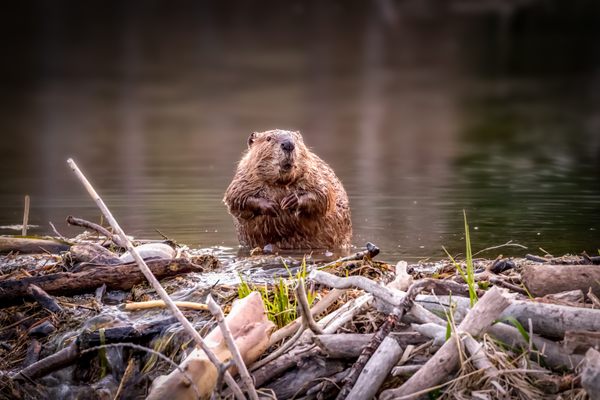
We slowed as we entered the cove where Balken hoped to set up camp. On shore, three river otters assembled like siblings, slick and whiskered. They bobbed around each other, so close together they seemed like a single animal, a three-bodied mustelid. Their ancestors were introduced in Utah in 1989, long after the state’s otter population had been hunted, trapped, and fragmented to extinction. The newcomers thrived, and otters are now seen down the Green and Colorado rivers and on Lake Powell.
“They don’t want to give up this spot,” Balken said over the motor’s putter. He pushed the boat closer as the otters wove around each other and entered the water, slipping under the surface, out of sight.
We hopped ashore onto a hard pad of the sand that caps the Dominy Formation. Ross pounded the sand stake with a mallet and tied off the bowline. We were home for the night, Stella an hour behind us.
An hour’s walk up a clear, sinewy creek, where the land had been exposed for three or four years, we found Gooding’s willow and coyote willow. Another few years higher, we found an 18-foot-tall cottonwood, its trunk bigger than two hands could encircle.
One of the first plants to show up after the water recedes is Russian thistle, or tumbleweed. A single prickly tumbleweed can consume 40 gallons of groundwater over its lifespan, but this non-native species is also known to draw toxins out of soils, possibly clearing the way for the willows and cottonwoods that follow it. I saw a few shoots of tamarisk, another non-native, in the canyons, but cottonwood saplings numbered in the hundreds. The original ecology was returning.
David Wegner, one of the founding members of the Glen Canyon Institute, is retired from the U.S. House of Representatives, where he served as a member of the senior staff and specialized in water, energy, climate change and science. He recently visited Lake Powell, and when he saw a 50-foot-tall cottonwood standing where he’d previously known nothing but water, he hugged the tree. A place he believed to be lost, a place he never expected to see firsthand, had returned to the world. He sees the drawdown as an incredible ecological opportunity. After two dams were removed from the Elwha River in Washington, “we spent millions on reshaping the rivers, millions on replanting,” he said. “We have spent zero on the restoration and recovery of Glen Canyon. It is re-establishing with absolutely zero investment from us.”
It is, without doubt, erupting with life: On a Dominy bench, alongside rabbitbrush and ricegrass, we found a flaming green cannabis plant. Maybe someone dropped their stash over the side of a houseboat in 1985, letting the seeds sink into anaerobic depths of sediment, where they were preserved until the day when the plant could sprout and its chunky buds glint crystalline in the sun.
The newly exposed land falls within the 1.25-million-acre Glen Canyon National Recreation Area. According to the 1979 General Management Plan for Glen Canyon, the water portion of the lake is managed as recreation, whereas the land, for the most part, is considered a “natural zone” and treated as wilderness. Most of the emergent canyons and landforms are wilderness by default.
Not all of the conservation news from Glen Canyon is glowing, especially when viewed from downstream. The dam’s penstocks, which take up water from Lake Powell and send it through the hydropower turbines, are no longer drawing from the cold deep tank of the reservoir. Instead, they’re pulling from just below the surface, and that warmer water is heating up the river below the dam, making it more hospitable to the non-native sport fish that live in the reservoir’s upper layers. Now, more of those fish are being flushed through the turbines, and surviving to compete with the Grand Canyon’s carefully curated native species. Fish biologists are especially concerned about the humpback chub, which is already hanging by a thread.
Meanwhile, Glen Canyon Dam is still holding back a mountain of sediment, starving Grand Canyon beaches and other streamside habitats of material that would otherwise have gradually flowed downstream over the decades. Downstream river levels throb and dwindle in accordance with the dam and its electricity demands, not seasonal rhythms. The incoming sport fish are one more insult to an already abused system. Recovery on one side of the dam is disaster on the other.
Could the lake ever cover Glen Canyon again? “It may come back up a few feet here and there because of variability in our water supply,” David Wegner told me, “but I’m not hearing from anybody who looks at the existing data, and the structural deficit that occurs from over-allocating a diminishing supply, that the water will ever come up.”
I took the question to Brad Udall, a senior water and climate research scientist at Colorado State University’s Colorado Water Center. How many heavy winter snowpacks would be needed to put Powell back on the rise? “Five or six really big years in a row,” Udall said. “Given the demands on the system, that’s how much it would take to turn this around.”
While Udall celebrates the return of Glen Canyon, and is as likely to hug a tree as Wegner—in his 20s, he worked as a river guide on the Colorado—he is chilled by the possible ramifications if Lake Powell drops below its current levels. “I think there’s a real reason to keep water above the penstocks,” Udall said. Below that, he added, is “dangerous territory.”
The danger lies in the engineering of the dam. The penstocks are positioned more than halfway up the lake side of the dam, 333 feet above its base. If water levels drop too close to or below the penstocks, they will no longer supply water to the hydropower turbines. Levels have recently drawn near enough to the penstocks that air bubbles pulled from near the water’s surface might begin to collapse, or cavitate, as they pass through the turbines. The resulting pressure waves can tear apart a tunnel’s innards, eroding concrete and threatening the dam’s integrity. During the floods of 1983, cavitation caused the interior of one of the dam’s spillways to disintegrate; by the time it was shut down, the passage was vomiting boulders and concrete. Ninety-six feet below the hydropower penstocks are four tubes designed to release excess water through the dam during wet years, which might provide a last-ditch route for water if the reservoir continues to drop. But Udall said these bypass tubes were never designed for constant use, and he worries that they will not reliably move water downstream. Udall’s hope, for now, is to keep lake levels where they are, even as snowpack declines. Current water restrictions for downstream users, even those enacted under emergency drought policies, are not enough, he said. Less water must leave the reservoir. He sees a greatly reduced Colorado River below the dam, enough for boating but with no more big flows. “Cuts need to happen this year, more than are being recommended. We need to protect that power pool at Powell.”
If water can no longer pass through Glen Canyon Dam, the Grand Canyon will all but dry up, and Lake Mead will rapidly dwindle. Seven states will lose the hydropower they receive from Glen Canyon Dam. Over the century since the Colorado River Compact ignored Indigenous rights to the river, 17 of the basin’s 30 federally recognized tribal governments have established legal rights to water below Lake Powell, but many are still battling for access to that water and for a long-denied role in basin negotiations. If water stops flowing through the dam, these sovereign nations may never see their rights fully realized.
“This river is our namesake, it is our life,” Amelia Flores (Mohave), chairwoman of the Colorado River Indian Tribes, said in testimony to the Senate Committee on Indian Affairs in March 2022. “And if we do not control our water, history tells us that others will.”
In the summer of 1998, when I rowed baggage rafts through the Grand Canyon, the flow on the Colorado River often exceeded 20,000 cubic feet per second and Lake Powell was nearly full. By the time Shyanne Yazzie, a 30-year-old guide who grew up next to Glen Canyon Dam in Page, Arizona, started working in the Grand Canyon in the late 2010s, typical flows fluctuated between 12,000 and 18,000 cubic feet per second, and outflows from the dam have continued to decrease. “Now, when we have 12,000,” she said, “I think we have so much water!” The rapids are getting rockier, harder to navigate, and less conducive to rafts made for big water. Yazzie said that the rumor among her fellow guides is that next season’s flows could drop to 3,000 cubic feet per second.
Yazzie was born on the Navajo Reservation, and her Diné ancestors have lived in and around Glen Canyon for centuries. She was raised with Lake Powell, camping on its shores with her family and riding Ski-Doos to Lone Rock, a landmark that used to stick up from the water like a giant thumb and now stands on a barren desert plain.
Yazzie wants Lake Powell back, but she feels torn. “It would be amazing to see the untouched Glen Canyon,” she said. “It would be amazing to see the water go up, because so many people rely on it.”
When she was a kid, she said, the lake’s water rose high enough for boats to pass under the sandstone archway of Rainbow Bridge. But she knew that, according to Navajo tradition, it was disrespectful to go under the arch; one should go around it. In the mid-1970s, three Navajo Nation chapters, along with several individual tribal members, unsuccessfully sued the Bureau of Reclamation and other federal agencies over Lake Powell’s imminent flooding of burial grounds and other sacred sites near Rainbow Bridge. Now the water is a mile away and the bridge stands alone in the desert, its old self.

Yazzie’s mother, Joanne Yazzie, was born not far from Page in the community of First Windmill, Arizona. She recalls visiting Powell in high school in the mid-1980s, when water levels reached their peak. Releases roared from the dam, swelling the river to more than 100,000 cubic feet per second as it entered the Grand Canyon.
She went to the lake when her kids were little, and over the years she watched its level fall, but until recently, the water was still high enough to feel abundant. Now, she said, it feels different. “Places where we used to go swimming, we can’t, because there are canyons and cliffs,” she said. She sees a world out of kilter, and sees what’s happening to Lake Powell as part of the dislocation. “In the Navajo culture, we think we’re really in deep trouble right now,” she said.
Like her daughter, Joanne Yazzie wants to see Lake Powell at a healthier, higher level. “The lake does help the people,” she said. “Not only us, but down the river where it’s even drier. We have to think of the whole picture.”
At dawn, Eric Balken and I sat in Cathedral in the Desert, listening to the waterfall echo within its scalloped sandstone. Sunlight was half an hour from touching the highest cliffs, six hours from reaching us. Sitting on a sandy slope of eroding lake deposits, we looked up to where, not long ago, the dual pontoons of houseboats would have motored above our heads.
With his voice resonating inside the cathedral, Balken asked, “What would we have to sacrifice to refill the reservoir? Are you going to let Lake Mead go dry and then jeopardize the water infrastructure in the Lower Basin and their water security? That’s a hard sell. Lake Mead’s the more important reservoir.”
The Lower Basin includes all those with a legal claim to Colorado River water below Glen Canyon Dam: tribal governments, the national government of Mexico, and the state governments of Arizona, Nevada, and California. These governments and their people need their water, Balken said, and both Powell and Mead are holding it. The decision to keep Lake Powell or let it go, he said, will have nothing to do with recreation or hydropower, much less this waterfall and its maidenhair ferns. “It’s going to be a decision about water storage and allocation,” he said. “And nothing else.”
Last spring, the Interior Department set new emergency guidelines for dam operations on the Colorado, reducing releases from Glen Canyon Dam and increasing releases from reservoirs upstream. These higher reservoirs are now bottoming out, bridge pylons standing dry so that Powell can survive another season. The federal government has ordered all of the Colorado River Basin states to dramatically cut their water use — or have it done for them.
Balken said, “The Bureau of Reclamation, if I had to bet money, they’re going to hold back more water in Powell in the next few years, and they’re going to cut down delivery downstream. They’re already doing fill-Powell-first de facto. They are so afraid of operating below power pool — not because of hydropower, because of water delivery. They’re going to do everything they can to prop it up above minimum power pool until they physically modify the dam.”
For Balken, salvaging this reservoir is the wrong decision. Operating at these levels in a drying climate is unpredictable and dangerous, and it involves curtailing downstream deliveries.
“If we’re rethinking the delivery obligation, why aren’t we rethinking the dam?” he asked. “We keep walking down the path of decisions that were made in the past, even if they’re based on flawed assumptions. Why not re-engineer Glen Canyon Dam, let the river run free, and put the water in Lake Mead?”
He sees this future as almost inevitable. Having two reservoirs, Mead and Powell, both atrophying at once is like having too many bank accounts open with too little money in them, he said. In this time of triage, Balken thinks we need to focus on Mead, and let Powell go.
A datura plant with creamy white blossoms grows between the legs of a half-buried beach chair. A sunken boat turns to bones. If you dig down deep enough to reach a layer spiked with metal pull tabs, you’ll know it was deposited in the late 1960s, when the lake was filling.
As the dam’s floodgates closed, archaeologists scoured Glen Canyon, collecting what they could, relocating artifacts when possible, and documenting thousands of sites ancestral to at least seven modern tribes. The predominant rock art found here, which is 3,000 to 5,000 years old and mostly sunk beneath the reservoir, is called Glen Canyon Linear, a skeletal, checkerboard style depicting animals, humans, spirit beings and geometric forms. These Indigenous ancestors lived in a sprawling desert sanctuary of rivers and springs. Their rock art style extends for a hundred miles or more in all directions, and the center of the style, its type locality, is the Glen.
The exploitation of the river and the canyons has also destroyed much of its human history. Three-quarters of the ancestral sites within the reservoir are thought to have been destroyed, often by the lashing of boat wakes or by visitors who could step off the deck of a speedboat and into the door of a once-inaccessible cliff dwelling. As the reservoir filled, graffiti rose with the lake level, and higher and higher rock art sites fell prey to vandalism.
What endures, in many places, are toeholds. In a landscape of cliffs and precipitous falls, First Peoples pecked ladders into the rock, vertical paths to cliff dwellings and granaries. While skimming a sandstone wall in the main channel with Stella, we came upon a set of ancient toeholds, out of the water for several months at most. As we slowed, water from a passing speedboat bucked around us. The holds led to an alcove that must have once held a rock-and-mortar structure, long since erased by visitors and waves. Falling from these steps would have probably meant death, a hundred-foot tumble past ledges, slopes and cliff bands. Today it would mean plummeting into the water.
A story from the Hopi, direct descendants of these stairmakers, says that the previous world flooded — filled with water all the way to the top. It was a catastrophic end, a drowning. The people who escaped made it to the current world, in some tellings rising on a reed boat, in others climbing a ladder. They found their way up from the flood and arrived in a dry, sunlit land above. This is how the first people came to the world.
Stella bucked and sloshed on the waves. We held her gunnels, enchanted by this ancient stairway, each hold big enough for a few fingers or toes, just deep enough to nick the rockface with shadows. Where the cliff went underwater, the holds turned green beneath the surface, then black, then disappeared. They looked like the tip of a ladder leaning against the rock, a way up from the dark.


Follow us on Twitter to get the latest on the world's hidden wonders.
Like us on Facebook to get the latest on the world's hidden wonders.
Follow us on Twitter Like us on Facebook